• We have updated our Community Code of Conduct. Please read through the new rules for the forum that are an integral part of Paradox Interactive’s User Agreement.
You have put too many Veps people on the East side.

here is what Russian Wikipedia says about the Zavolochye region


I think the Veps population of that region is already mixed with the new coming Slavic population.

Exactly the same situation happened with Onega for example(same dates as you can see)
My reasoning for that was with how there are no recorded Russian settlements from this area from the time. Kevrola is the furthest they seem to have gotten along the Pinega river. As for the Yug river, that too was held by the Chud'. There's also accounts of land exchange with Chud' in the area.
It was first known from a deed of sale dating back to 1315, according to which the Novgorod posadnik Vasily Matveyevich acquired land along the Vaga River from the Chud elders Rovda, Ignatz and Azika for 20 thousand squirrels and 10 rubles in cash.

Here's some reading on Nikolsk district at the time. The Russians did eventually assimilate the Chud', but this process had not been finished by the 14th century as there are accounts of them way after that.
 
Last edited:
  • 1
Reactions:
View attachment 1228714View attachment 1228715
Here is my proposal for the cultures of the East.

Let's start from the top to bottom:

I have put Nenets people at the top because the colonisation of those lands by Russians has not yet started.
Mezen city (not where location Mezen is located) was founded in the XVI century.
Locations Nes, Vizhas and Oma are currently populated by Nenets people. 7a on the map

Sloboda Lampozhnya was founded in 1545 by the Slavic population. However, when it was mentioned by Ivan the Terrible it was addressed to the Samoyedic people (Nenets) who lived near Kanin und Timan tundra

View attachment 1228683View attachment 1228684
The lands there are not highly populated even now, with Mezen the only big urban place

Komi-Zyrian
Pinega
The Pinega settlements were first mentioned in the charter, drawn up in Novgorod in 1137 by order of Prince Svyatoslav Olgovich. I think it had time to assimilate into the Novgorodian trade. This location should be a part of Novgorod.
However, the lower part of Mezen and near Pinega river were populated by Komi people
View attachment 1228690View attachment 1228691View attachment 1228696
location Koptyuga for example is still populated by Komi people even today

Chakola and Kevrola(Shardonem location, should be renamed!! ) are two cities mentioned in 1137 (from the Russian Wikipedia of those cities)
However, these are the deepest ones. This is why I think Komi people were pushed from Pinega River (as you can see they live near but not directly on)

Toyma was a Novgorodian city

Near modern Kotlas, there was a Finno-Ugric settlement of Pyras(as I understand Pyras location). In the XIX century publicism, it is indicated that Pyras was located at the mouth of the Vychegda at the place of Kotlas. Zyrian settlement Pyras in the mouth of Vychegda existed already in the XIV century.

It was here that St. Stephen of Perm began his preaching among the Komi-Zyrian in 1379.

In the Vychegodsko-Vymsk chronicle, there is the following record:

So it should have Komi culture

then I have assigned cultures based on this
View attachment 1228703
It shows Merya, Mari and Komi people areas. Kokshary are a debatable population this is why I have not relied on that from this map.
Light Green represents assimilated people, Green Merya, pink Mari and Kimo with purple

Here is an article about the population near Unzha

It shows a lot of Mari cities like Shanga, Yakshan, Yur and others
View attachment 1228706

Vetluga - in the 13th century was Mari city named Yur.
River Vetluga was fully controlled by the Mari people. In 1280 Mari kuguz(prince) Bai fortified Yur city. In the 14th century kuguz Osh Pandash won against Galich principality. It was conquered only in 1468 by Galich prince Semyon Romanovich Yaroslavsky. The City of Yur was fully burned and destroyed. And Only later was colonised by Russians.

The main thing to understand is that the Slavic population ran away from the Golden Horde, which is generally North. This is why it is too early for now to assign a lot of lands of Mari and Merya to Muscovite culture.
I would make Vokhma Mari as that area had Mari archaeological sites and the hydronym is Mari.
1733846672748.png

Zavolochye Chud' are represented as still existing on this map.
 
Last edited:
I would make Vokhma Mari as that area had Mari archaeological sites and the hydronym is Mari.
View attachment 1228758
Zavolochye Chud' are represented as still existing on this map.
Yes, this is how I started digging into it, but I couldn’t find other sources about them. Like for Mari for example. Merya is also sometimes depicted, and at least Galich-Merskoy indicate that Merya was there.

Also they are called Kokshary here which is second level confusing
 
Didn't Old Church Slavonic only further influence Russian after Muscovy took over? What's evidence that even during the earlier Rus period the North-East princes were more influenced by Slavonic?

About Novgoridan, but that doesn't mean East Slavic never existed, it only suggests it could have split earlier and also might just mean that Novgorodian is the first branch to have split while the rest stayed together, which doesn't really change anything in regards to how to split East Slavic.

Also after reading more of it, I don't see how this guy supports the idea that East Slavic would have split in 2 Ruthenian-Russian languages/dialect areas in the 14th century:

"– Why are there two languages: Ukrainian and Belarusian?

But this is a very difficult question. It is very hot and sharply discussed now in Ukraine and Belarus. The differences between these languages are significant. Moreover, the Belarusian language as a whole is much more like Russian than Ukrainian. The proximity between the Belarusian language and South Great Russian speaking is especially great."
I quoted him to show the reason why the whole theory about ‘common East Slavic language’ might be doubtful. And any discussions about Ukrainian and Belarusian are not relevant for the game. Even though I have not heard about any 'sharply discussed questions'.

Here there is another example (with anothe view on the common East Slavic) Лексикология старорусского языка, immediately at the beginning:
Source.png


For those who cannot read Russian, it actually justifies the XIV century to be a time border between the common East Slavic and Old Russian.

I could add a dozen of Ukrainian scientists and sources too.
 
Last edited:
  • 3Like
  • 1
Reactions:
I quoted him to show the reason why the whole theory about ‘common East Slavic language’ might be doubtful. And any discussions about Ukrainian and Belarusian are not relevant for the game. Even though I have not heard about any 'sharply discussed questions'.

Here there is another example (with anothe view on the common East Slavic) Лексикология старорусского языка, immediately at the beginning:
View attachment 1228760

For those who cannot read Russian, it actually justifies the XIV century to be a time border between the common East Slavic and Old Russian.

I could add a dozen of Ukrainian scientists and sources too.
I'm unconvinced, because if Common East Slavic ended, again what justifies there being 2 languages? And not more? What is the logic that East Slavic should split between Ruthenian and Russian? My understanding is that East Slavic or at least Russian was divided in 3 dialectal bands north to south and the southern band pretty much blends into Ukranian and Belarusian, so linguistically shouldn't most of Russia south of Moscow not be "Ruthenian"?
 
Last edited:
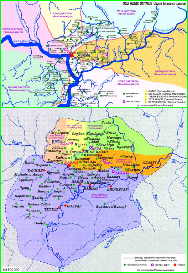
Ideally, Kazan area should be heavilly mixed between Chyvash (Bulgar population) and Kazani (Tatar population), here is map of ethnic mapeup of Kazan khanate in 15th century where yellow is Chuvash, dark green is tatar and light green around Kazan is Finno-Ugric population
1733931465763.png

This is where Bulgar population migrated after Tatar-mongol invasion

1733931499591.png

also, there are many modern placenames in Kazan, which is inaccurate because we have names of many local settlements

1733851916334.png
 
Last edited:
  • 4
  • 1Like
  • 1
Reactions:
Very small dynamic change i would like to see is Petsamo getting dynamically changed to «Fiskerhalvøya» if Norway manages to obtain the location. There were Norwegians who lived there called «Kola Norwegians» but they were expelled and persecuted by the Soviet Union.

It would be a little nice touch to add as it could possibly be colonized in game by Norway as it already borders it.

Edit: After further research Peisen would be a more appropiate name as it was used to refer to the whole location, while Fiskerhalvøya is only the peninsula in the location.
 
Last edited:
  • 1Like
Reactions:
I'm unconvinced, because if Common East Slavic ended, again what justifies there being 2 languages? And not more? What is the logic that East Slavic should split between Ruthenian and Russian? My understanding is that East Slavic or at least Russian was divided in 3 dialectal bands north to south and the southern band pretty much blends into Ukranian and Belarusian, so linguistically shouldn't most of Russia south of Moscow not be "Ruthenian"?
Because it's a commonly accepted fact by pretty all the scientists that all various dialects by the XIV century converged into groups that can be called those two languages. And the clear border just formed later because of political division Lithuania/Muscovy. So the devs have made a good research on the topic.

Also this is consistent with splitting West Slavic into Polish and Czechoslovakian, South Slavic into Bulgarian and South Slavic. So this follows this consistency.
And I would support this consistency for other languages. It also makes the game more flavouflul, adds variety and is much more relevant for the time frame.

Concerning this statement:
so linguistically shouldn't most of Russia south of Moscow not be "Ruthenian"?
I totally agree and that's why I proposed changes to the culture map so that Ruthenian language would have more historic coverage.

Actually in the already a dozen times shown here Koryakov map those two written languages are shown by the green and orange dashed lines:
Koryakov.png


Also there is another good post here with some useful data and scientists provided, that states a similar thing in all cases: what can be considered as the East Slavic, was most probably not actual by the XIV century. Because of huge natural linguistic changes in the XI – XIII centuries and political NE-SW division after the Mongolian invasion.
Russian linguists generally agree that Old East Slavic already had several dialect groups by the 11th-12th centuries; I found three main theories for the exact split. By the late 1300s, political developments had mostly cemented their status. They weren't a perfect match for the languages and dialects of today - not even mentioning the spread south and east - as there were additional demographic shifts after 1400 (especially around Velikiy Novgorod, Smolensk, and Belgorod). However, they provide a very good and decently convenient basis for the cultures, dialects, and languages in Project Caesar.

The three theories, as posited by the respective linguists, are:
1. Khaburgayev - southwestern (Halych-Volhynian), southern (Central-Eastern Ukrainian), central (modern Belarusian and Southern Russian), northwestern (Novgorod-Pskov), and northeastern (Vladimir-Suzdal)
2. Ivanov - southwestern (Halych-Volhynian and Central-Eastern Ukrainian), western (Smolensk-Polotsk), southeastern (Ryazan-Kursk-Chernihiv), northwestern (Novgorod-Pskov), and northeastern (Vladimir-Suzdal)
3. Zaliznyak - northwestern (Novgorod-Pskov) vs southern-central-eastern (everything else); according to him, there were regional variances within the second group as early as 11th century, but this was the primary split until the Novgorod-Pskov and Vladimir-Suzdal dialects started merging together around 1200; this would set Novgorod-Pskov dialects solidly apart from the rest but would not preclude the rest from being split into different cultures in Project Caesar.
 
  • 2
Reactions:
CORRECTIONS

Renamed the following:
  • Locations (only corrections. Additionally renamed all locations to standardized form):
They're still not consistent. :-(
E.g. Копорье (Kopor'ye) uses both the ' sign to signify ь and the ye to indicate the [je] sound sequence, while there are several places which don't do either (e.g. Nizhel'skoe, Azeevo, Ryasan).

I think another renaming pass is needed.
 
  • 3
  • 1Like
Reactions:
Because it's a commonly accepted fact by pretty all the scientists that all various dialects by the XIV century converged into groups that can be called those two languages. And the clear border just formed later because of political division Lithuania/Muscovy. So the devs have made a good research on the topic.

Also this is consistent with splitting West Slavic into Polish and Czechoslovakian, South Slavic into Bulgarian and South Slavic. So this follows this consistency.
And I would support this consistency for other languages. It also makes the game more flavouflul, adds variety and is much more relevant for the time frame.

Concerning this statement:

I totally agree and that's why I proposed changes to the culture map so that Ruthenian language would have more historic coverage.

Actually in the already a dozen times shown here Koryakov map those two written languages are shown by the green and orange dashed lines:
View attachment 1228817

Also there is another good post here with some useful data and scientists provided, that states a similar thing in all cases: what can be considered as the East Slavic, was most probably not actual by the XIV century. Because of huge natural linguistic changes in the XI – XIII centuries and political NE-SW division after the Mongolian invasion.
What do the colored areas and the last line in the legend mean?
 
I don't clearly understand why the "Tatar Yoke" IG, which is obviously meant to represent the system where Moscow collected tribute from other princes on behalf of the Golden Horde, includes so many princes.

I can't find a great source for this right now, but here is a short wikipedia excerpt that claims that Ryazan delivered their tribute directly to the Khan.

View attachment 1228549

In general, I think that studying the history of Moscow in this period should eventually make it clear that Moscow was specifically in a rivalry with other princes in the Vladimir-Suzdal land, chiefly Tver, and interacted less with outside princes such as Smolensk and Kiev. Therefore I argue that the Tatar Yoke IG should be reduced in size to only the Vladimir land.

It really doesn't make much sense for an IG whose flavour title is "Grand Prince of Vladimir" to include all of this land that was never part of Vladimir.

View attachment 1228550
Would it make sense to just have there be a special status in the Tatar Yoke IO for states which don't offer tax to Muscovy? Or is it not useful and should they just be made standard vassals of the Golden Horde.
 
  • 1Like
Reactions:
While the Moscovite ruler was elected as ruler of Novgorod, by 1337, the elective knyaz position was mostly nominal and served to get some allies, the actual ruler was elected chairman of Veche (boyar council) and was reelected each 1-2 years.
 
  • 5Like
Reactions:
1733860232557.png


1733861176128.png

1733859948262.png


Livvi Karelians aka Olonets Karelians should extend further south than currently, at least covering these locations:

1733860547684.png


Olonets was an important karelian settlement, one of the oldest ones, and was very likely not majority Novgorodian in 1337.

Ludic is technically a dialect of Karelian, acting as a transition between it and Veps. As such in-game it can just be represented by Karelian, in my opinion. As such, Vazhiny location could probably also have Karelian majority culture.
 
Last edited:
  • 4Like
  • 2
  • 1
Reactions:
  • 1Like
Reactions: