• We have updated our Community Code of Conduct. Please read through the new rules for the forum that are an integral part of Paradox Interactive’s User Agreement.

Tinto Maps #10 - 12th of July 2024 - Syrian Levant & Egypt

Hello everyone, and welcome to another Tinto Maps! We’re back after celebrating the most important victories over Germany and France since the 30 Years War a hard week of work, and we’re ready to share with you the region of the Syrian Levant & Egypt (actually, we’re revealing a bit more of what those regions would be, to cover the complete extension of the Mamlūk Sultanate). Let’s go!

Countries:
Countries.png

The Mamlūk Sultanate is the main power of the region, a situation achieved after the defeat of the Mongols at the Battles of Ain Jalut and Marj al-Saffar, and the fall of Acre, the last stronghold of the Crusader states in Outremer. The latter's legacy is still handled by the Kingdom of Cyprus, ruled by Hugues IV of Lusignan. Apart from that, we can see the realm of Candia, a subject governed by the Serene Republic of Venice, and some Arabic tribes, such as the Hutaym and the Anizah. Oh, and also, to the south-west, you might have noticed some oases ruled by either the Mamluks, or Fezzan; I opted for not coloring the wastelands, as usual, but also the corridors, a type of terrain present in other GSGs, that we have in Project Caesar. I’ll talk more about them under the ‘Locations’ section of the DD, but I just want to note one more thing: the connection down the Nile is a regular one, with a border existing between the Mamluks and Makuria (the country that controls the small chunk of land at the very south of the image).

Dynasties:
Dynasties.png

The Bahri Mamluks have ruled the Sultanate since they deposed the Ayyubids, almost a century before the start of the game. It could maybe be a bit more accurate to depict Sultan al-Nasir Muhammad as an ibn Qalawun (‘of the lineage of Qalawun’), but the dynastical dynamics of the Mamluk rulers are not so easy to portray, so we opted for the moment to better use Bahriyya. Apart from that, you may also see the neighboring dynasties, such as the already-mentioned House of Lusignan, or the Hethumian of Cilicia.

Locations:
Locations 1.png

Locations 2.png

Locations 3.png

Locations 4.png
Here you can see the locations of the entire region, and also closer chunks behind the ‘Spoiler’ button. The most interesting feature to talk about is that of the corridors, something that some of you might remember from ‘Imperator: Rome’, but also something new to the rest. The corridors are empty locations, with no population or resources, but that allows connection between the locations at their sides, for some mechanics that we’ve already mentioned (market access, control), and some others that we haven’t (army movement). This is the way that we’ve chosen to portray the Saharan corridors, that allow for a connection between the Maghreb and the Mashreq, and Western and Central Africa. There are also some regular locations over those corridors, with population, resources, etc., that can be controlled by countries, which portray the desert oases that made for important outposts in the different Saharan routes. Not all the connections are throughout corridors, though; outside of the image, the Nile River valley allows for regular locations all the way down from Egypt to Nubia, the last location held by the Mamluks being that of Aswan, while the first held by Makuria, not shown in the screenshot, being Qasr Ibrim. We will talk more about Nubia and Ethiopia in a future Tinto Maps.

Provinces:
Provinces.png

Usual provinces mapmode; please let us know of any spelling or naming suggestions that come to your mind.

Areas:
Areas.png

A new mapmode that has been requested in previous Tinto Maps, and that we’re now incorporating.

Terrain:
Climate.png

Topography.png

Vegetation.png

The climate is dominated by a mix of Mediterranean, Arid, and Cold Arid. The topography of the region is quite flat, with some hills and mountains on Mount Lebanon and Anti-Lebanon, Mount Sinai, and the verge of the Arabian plateau; and some marshland over the Nile Delta, of course. Regarding the vegetation, desert and sparse vegetation dominate most of the region, with some woods and forests over Levant, and the Nile fertile farmlands, the bread basket of the Eastern Mediterranean.

Cultures:
Cultures.png

Here starts the fun… Those countries ruling over the Middle East will face the challenge of managing several different cultural minorities. Libyan, Egyptian, Sa'idi, Bedouin, Ḥijāzī, Najidi (the green one to their right), Levantine, and Iraqi (the light blue at the top right of the picture) are all different regional cultures of Arabic-speaking people. Something interesting is that most of Bedouin pops are tribesmen, instead of peasants, portraying their traditional social organization. Coming to important minority groups, Coptic people are quite important in Egypt, accounting for about 10% of the population of the Mamlūk Sultanate. The other important minority are the Syriacs, as they also account for another 10% of the population, and are a cultural majority in a few locations. Apart from those, there are also Armenians, Kurds, and Turkomans on the divide between Anatolia, Syria, and Jazira, Alawites Shiites in Syria, Mizrahi Jews all over the region, Samaritans in Palestine, and Greeks in Crete, Cyprus, and some in Alexandria. Oh, also the Saharan cultures of the Eastern Berbers and the Toubou over some of the Saharan oases.

Religions:
Religion.png

More fun. In this region, we have:
  • Sunni Muslims
  • Miaphysite Christians
  • Orthodox Christians
  • Shia Muslims
  • Catholic Christians
  • Druzes
  • Jews
  • Nestorian Christians (the ‘label’ we’re using to depict the Church of the East)
  • Samaritans
  • Yazidi

Relating these religions to the previous cultures, we can tell you most of the Arabic-speaking cultures are Sunni Muslims, with some Shia Muslims in Syria and Lebanon. Most of the Coptic are Miaphysite, adhering to the Patriarchate of Alexandria, although some of there still follow the Orthodoxy of Constantinople. The Syriacs are also religiously divided, with some being Nestorians (the current name we have to cover the confessions related to the Church of the East), some Miaphysites, some Orthodox, and even some Catholics in Lebanon. And then we have some cultural-religious minorities, such as the Alawite Shiites, the Druzes (which are of Levantine culture), the Mizrahi Jews, the Samaritans, and the Yazidi (which are of Kurd culture).


Raw Materials:
Raw Materials.png

There are some materials that are more unique to this region, such as the Dates in the arid fringes. The Nile Valley and Delta are incredibly fertile, having plenty of different crops: Wheat, Rice, Legumes, Sugar, Cotton, Fiber Crops (=Linen), etc. Livestock, Wool, and Horses are also important resources for the people across the region. There are also some metals present in the region, such as Copper in Cyprus and around the Red Sea, Iron, Tin, some Lead, and some interesting sources of Alum.

Markets:
Markets.png

The main market centers of the region are Alexandria (yeah, it’s there! I’ve already reported its weird name-wrapping and one of our programmers is going to take a look at it) for the Mashreq, Damascus for the Syrian Levant and Mecca for the Hejaz.

Country and Location Population:
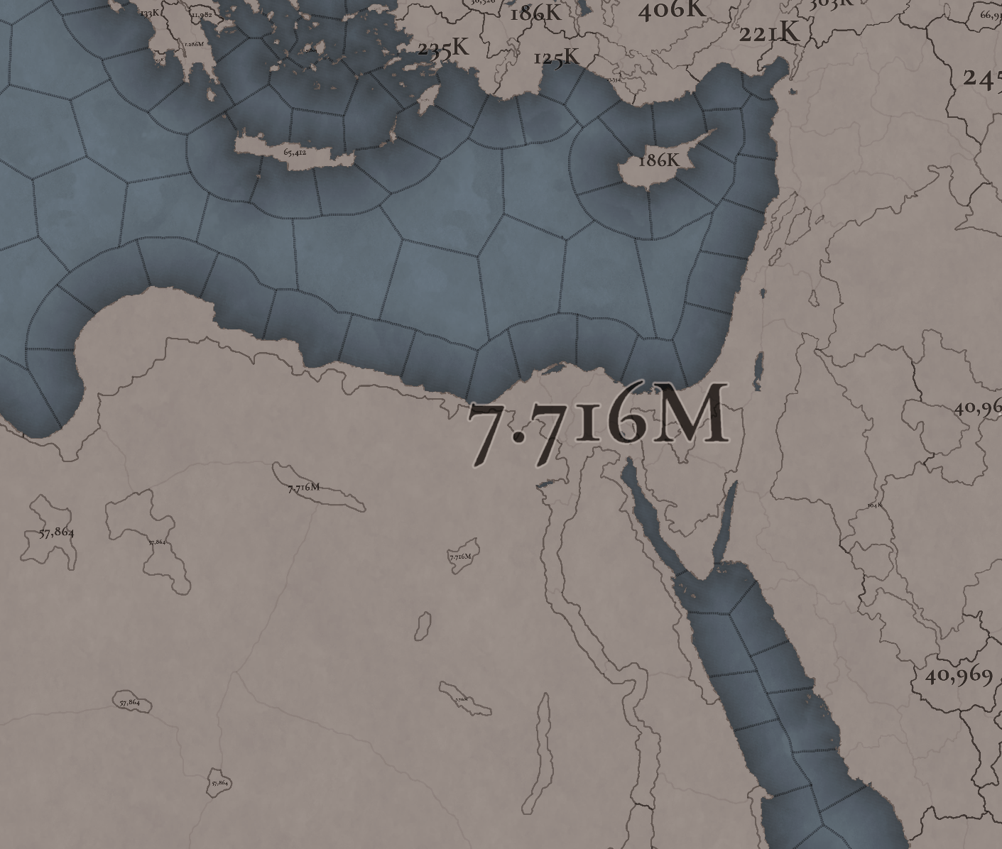
Country Population .png

Location Population 1.png

Location Population 2.png

Location Population 3.png
The population of the region points to Egypt being its powerhouse, with several million people being supported being the Nile Valley and Delta. Apart from that, the Syrian Levant has a very decent population, making the Mamlūk Sultanate a dreadful rival to have in 1337. The arid fringes make for a way more difficult food production and population sustainability, making them more of strategic value, by their position, resources, etc.

And that’s all for today! Next week @Johan will show you Scandinavia, the very first map that was crafted for Project Caesar! Cheers!
 
  • 176Like
  • 54Love
  • 7
  • 4
  • 4
  • 1Haha
Reactions:
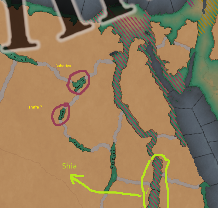
I believe that the Bahariya and Farafra oases should have some minority of Christians.

Quote from the Catalan Wikipedia:

It was conquered by Ibn al-As in the middle of the 7th century. Under the Muslims, it was known again as the Oasis of the North or Waha al-Khas . In 943/944 , it appeared under the rule of an Amazigh emir named Abd-al-Màlik ibn Marwan, who was fully independent. Then it fell into the hands of the Fatimites, who appointed a governor. Under the Mamluks it constituted a feud; the oasis suffered some attacks from the Bedouins and the Amazigh. The Christian community existed until the 16th century or perhaps until the 17th . The cultivation of wine, due to the prohibition of the product by the Muslims, ended and the economy entered into decline; olives and dates were subjected to too high rates; many fields were covered with sand.

Quote from the Catalan Wikipedia:

It is the ancient Tyhw ('land of oxen') of the time of the Pharaohs, and the Greek and Roman Trinytheos . Its population in the Middle Ages was Coptic , but under Ottoman rule it became Muslim. In 1860 , it passed into the hands of the Sanusiyya sect , but sovereignty remained Egyptian.

What do you think about adding the Wahati culture to the oases in northern Egypt?

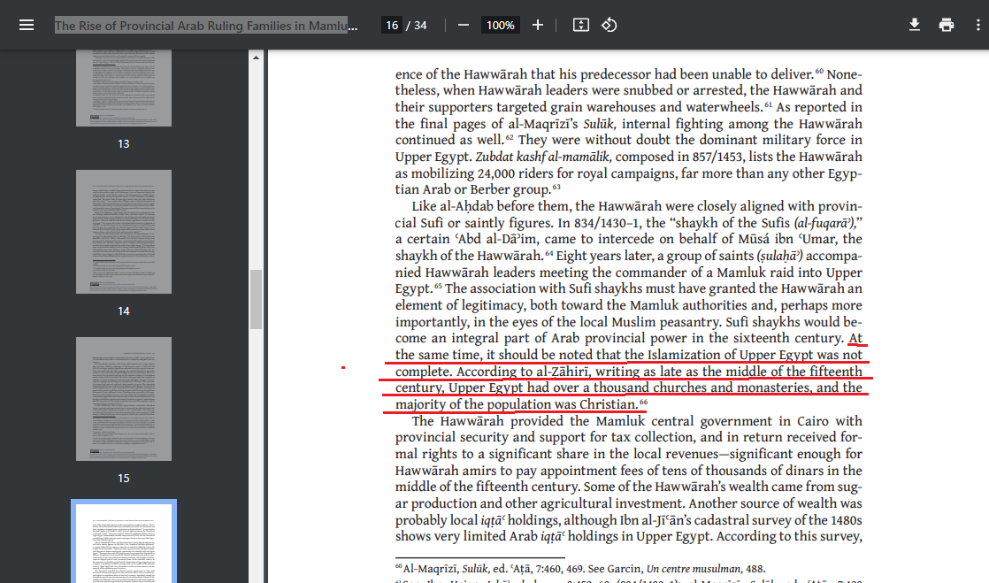
Quote from the pdf file titled: The Rise of Provincial Arab Ruling Families in Mamluk Egypt; 1350–1517
https://knowledge.uchicago.edu/record/5403/files/MSR-XXV-Rapoport.pdf
The same time, it should be noted that the Islamization of Upper Egypt was not
complete. According to al-Ẓāhirī, writing as late as the middle of the fifteenth
century, Upper Egypt had over a thousand churches and monasteries, and the
majority of the population was Christian.
copt.png
What do you think about making Bashmur a tag for release for Copts?
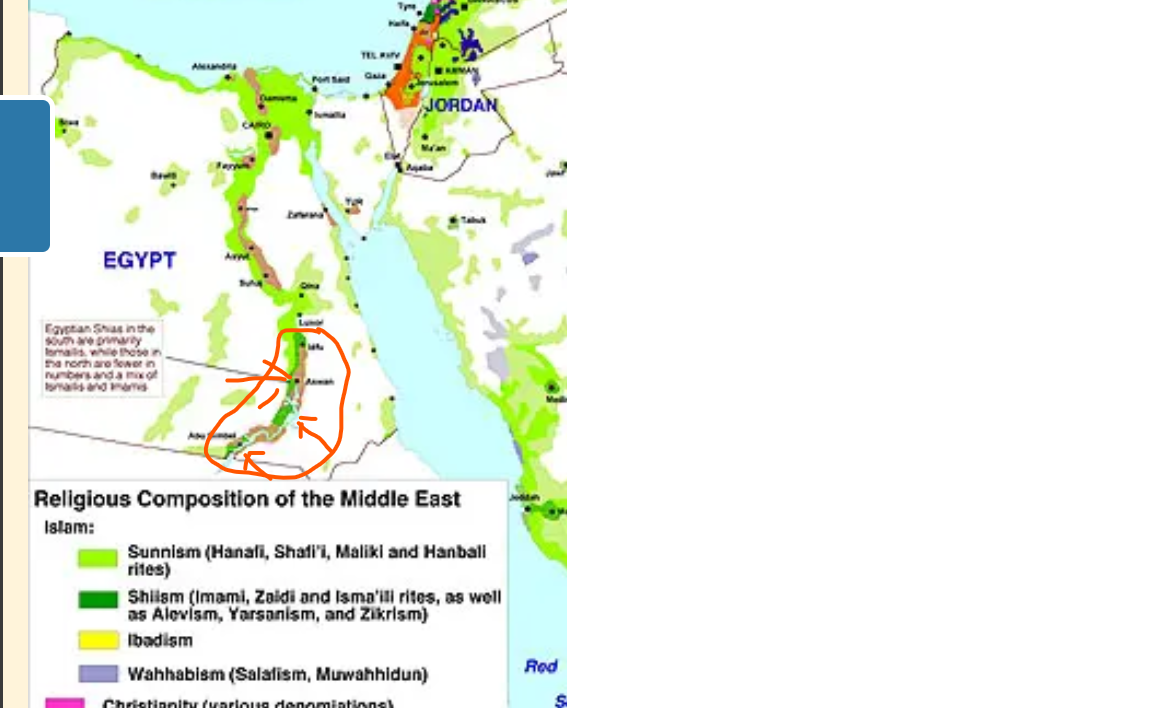
The Kunuz tribe, descendants of the Banu Kanz and Nubians, practice Shi'ite Islam. Aswan and the surrounding area should have some Shiite presence.

Shia.png
Religion.png
 
Last edited:
  • 8Like
  • 3
Reactions:
No, they don't. They are Maliki Sunnis, like all the other Nubians and Arabized Nubians. In 1337 the overwhelming majority was still Christian, anyway.
They may be mostly Sunni now, but before they were Shiites.
This region should be mixed 80%-70% Christians 20%-30% Shiites

Page in Arabic:

Quote;

The Kunooz Revolution is considered the last Fatimid Ismaili revolution in Egypt, if we exclude the Qurayshi alliance revolution led by Prince Sharif Hisn al-Din Tha’lab al-Ja’fari al-Talibi al-Zainabi al-Dayruti, during the reign of the Mamluk Sultan al-Mu’izz Izz al-Din Aybak al-Turkmani, about which opinions differ between being Fatimid Ismaili who wanted to restore the caliphate to the Fatimid family, and being Zaydi , according to which Prince Hisn al-Din Tha’lab wanted the caliphate for himself. Therefore, the Qurayshi alliance revolution is considered the last Shiite revolution, while the Kunooz Revolution is the last Shiite Ismaili revolution that is definitely Ismaili.

The suppression of the Fatimid Kunuz revolt was not the end of the Kunuz Emirate, as the Kunuz Emirate remained in existence and had the upper hand in Upper Egypt until it was undermined by the Mamluk Sultan Al-Zahir Baybars in his campaign on southern Egypt, which also included eliminating the power of the Beja tribes . The result of his campaign was the destruction of the port of Aydhab near today’s Hala’ib , ending its role as an important port in the Red Sea trade and Hajj , and also pushing the Kunuz tribes south towards Nubia. Since that time, the Kunuz have been considered part of the Nubians, who are divided today into Kunuz and Fadija. The Kunuz have kept their name and are proud of it and their history to this day. Some Kunuz are still Ismaili Shiites and follow the Nizari sect known today as the Aga Khanis, i.e. followers of Imam Aga Khan . Aga Khan III mentioned in his memoirs the existence of Shiite Ismaili Nizari islands in Upper Egypt . Aga Khan III, who had been nominated in 1914 to assume the throne of Egypt, chose to be buried in Aswan , which was the capital of the Kunuz Emirate. He spoke about Aswan and its relationship with the Fatimid Caliphate and why he chose Aswan to be his resting place in his memoirs.
 
Last edited:
They may be mostly Sunni now, but before they were Shiites.
Peer-reviewed source needed.

This region should be mixed 70%-60% Christians 30%-40% Shiites
These are fantasy numbers. In 1337 Makuria was still intact and the vast majority of the Nubians would have still been Christian, at least in Makuria. The account of John of Syria confirms that most Nubians were nominally Christian as late as ca. 1500.

The suppression of the Fatimid Kunuz revolt was not the end of the Kunuz Emirate, as the Kunuz Emirate remained in existence and had the upper hand in Upper Egypt until it was undermined by the Mamluk Sultan Al-Zahir Baybars in his campaign on southern Egypt, which also included eliminating the power of the Beja tribes . The result of his campaign was the destruction of the port of Aydhab near today’s Hala’ib , ending its role as an important port in the Red Sea trade and Hajj , and also pushing the Kunuz tribes south towards Nubia.
Baybars lived in the late 13th century. He didn't destroy Aydhab, nor did he "undermine" the Banu Kanz. In fact he recruited them for his campaign in Nubia.
 
1721426773204.png

I don't think it's particularly fair to take the state of the coastal population in 1300 and extend it to the rest of the period since depopulation was an active policy that a player could (and likely would) do differently.
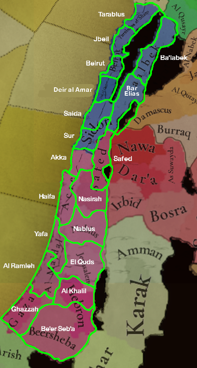
Added locations include Ramleh (the regional capital later on in the period), Jaffa (very important by the end of the period, would grow to be the second-most important by 1900), Haifa, Nazareth (could be Jenin actually, it was more important in the period, though Nazareth is probably more pertinent to most players), Tyre, Byblos and Bar Elias.
Lebanon certainly needs much more granularity. Much of the region's peculiarity comes not just from how diverse it is, but that its minorities live beside each other more than between each other. Lebanon imo needs more locations to show its spotty diversity, if that makes sense. Palestine is simply too location-sparse. I'd probably also add Caesarea and Jericho (Qaysariya and Ariha), with the latter specifically as an arid desert to represent the Judaean desert.
Tyre, Acre, Safad and Nazareth/Jenin should make up the Galilee-- the modern border between Lebanon and Palestine is largely colonial. I'm not too sure how to split the remainder of Palestine though. A "Yehuda was-Samara" and Palestinian littoral province could work. Still, I don't know how much of a cultural history there is between a split like that. Lebanon should at the least be split between a coastal Mount Lebanon and inner Beqaa province.
If further granularity is permissible (and it wouldn't leave the region particularly province-dense) I'd add Al Majdal back, Ariha and Qaysaria and another location in the centre of the Beqaa
 
  • 13Like
Reactions:
View attachment 1165568
I don't think it's particularly fair to take the state of the coastal population in 1300 and extend it to the rest of the period since depopulation was an active policy that a player could (and likely would) do differently.
Added locations include Ramleh (the regional capital later on in the period), Jaffa (very important by the end of the period, would grow to be the second-most important by 1900), Haifa, Nazareth (could be Jenin actually, it was more important in the period, though Nazareth is probably more pertinent to most players), Tyre, Byblos and Bar Elias.
Lebanon certainly needs much more granularity. Much of the region's peculiarity comes not just from how diverse it is, but that its minorities live beside each other more than between each other. Lebanon imo needs more locations to show its spotty diversity, if that makes sense. Palestine is simply too location-sparse. I'd probably also add Caesarea and Jericho (Qaysariya and Ariha), with the latter specifically as an arid desert to represent the Judaean desert.
Tyre, Acre, Safad and Nazareth/Jenin should make up the Galilee-- the modern border between Lebanon and Palestine is largely colonial. I'm not too sure how to split the remainder of Palestine though. A "Yehuda was-Samara" and Palestinian littoral province could work. Still, I don't know how much of a cultural history there is between a split like that. Lebanon should at the least be split between a coastal Mount Lebanon and inner Beqaa province.
If further granularity is permissible (and it wouldn't leave the region particularly province-dense) I'd add Al Majdal back, Ariha and Qaysaria and another location in the centre of the Beqaa
nice map, id make the Jaffa peninsula in the center of the location, to me it looks like its on the very edge. also seems to me Ramla is in the Jaffa location
 
  • 1Like
Reactions:
Thank you for the names and thank you very much for this very detailed Tinto talk on one of the more controversial regions. Great work on the cultures and religions. While I still need some time to look into the sources (e.g. Ibn Mammati) to get a better view of the Egyptian locations in that time, I already have a few suggestions.

1- Naming inconsistencies
a) El/Al inconsistency
In Egyptian Arabic, the definite article is EL, never Al. You have this correctly in the names of the locations El Mahalla, El Burullus, El Bahnasa, El Qasr, El Arish, El Qoseir, and El Tor as well as the province of El Minya. You however used the standard Arabic variety "Al" in some other location names for no apparent historical, regional, or linguistic reason. For example, the locations Al Buwit, Al-Balyana, Al Jundi, and the provinces Al Buhayra, Al Gharbiyya, Ash Sharqiya, and Al Jifar. Here I would recommend using the Egyptian Arabic variant of El, since these are Egyptian location names.

b) The hyphen after El/Al
Al-Balyana has a hyphen after the definite article. I suggest removing the hyphen and going with El Balyana.

c) Inconsistencies in the use of the definite article in location and province names.
Why is it El Bahnasa and Al Jifar but Faiyum and Tih, rather than El Faiyum and El Tih? There is no reason to choose one over the other, as both have the El in their Egyptian Arabic names. Some other names that should have El in their names drop it, such as El Bahariyya (meaning the northern [oasis]) drops to Bahariya. In another case, you have the location as Minya but the province as El Minya. My suggestion is to keep the El in the localization to Arabic-speaking ruling countries like with Welsh names and remove it for English and other Western languages since the definite article in the location name doesn't make sense in most place names in those languages (The London?). An Egyptian when switching to English will intuitively drop the El from the location names. "I went to Bahnasa" sounds more natural than "I went to El Bahnasa". Also, the official English names of modern Egyptian governorates drop the El. For example, what you have as Ash-Sharqiyya province is officially Sharqiya Governorate. I don't know about other varieties of Arabic, Egyptian Arabic is my native language. Another option is to just add El everywhere, but then you will have to add it to a few more location names.

d) Al Sharqiyya vs Ash-Sharqiyya
Do you want to go down the rabbit hole of Arabic sun and moon letters? Again I suggest dropping the article altogether.

e) Y-consonant gemination inconsistensies
Ash-Sharqiyya vs Bahariya .. pick one. In both standard and Egyptian Arabic, the Y is geminated and pronounced Sharqiyya and Bahariyya.

f) Egyptian Localization
Saint Anthony is Anba Antonios, Saint Katherine is Sant Katrin, Ras Gharib is Ras Ghareb, Hauf Ramsis is Hof Ramsis. Al Buhaira is El Beheira.

If you also need Coptic localization for the location names for some alternate history Coptic cultural revival plays, I am sure there are many Egyptians who can help you with that, including me.

2- Regions/Provinces Divisions
a) Upper and Lower Egypt
- Minya/ El Minya is definitely Upper Egypt, not Lower Egypt.
- Red Sea Cost has more cultural ties to Upper Egypt not Lower Egypt (check geography section).

b) Alexandria
- Alexandria was never part of "Al Buhayra/El Beheira", nor did it have many cultural or linguistic ties with it. II quickly checked Mamluk and Fatimid sources and this simply never happened.
- Matruh and Sallum were never under the administration of Cyranaeca/Barqa for any significant period of time.
The only division that makes sense here would be to remove Alexandria from "Al Buhayra/El Beheira" and create a new province including Alexandria, Matruh and Sallum, and call it Alexandria. Long Alexandria > Long Barqa, having basically Libya snake all the way to the edge of the Nile Delta doesn't make any sense.

3- Geography
You are missing two desert/mountain passes between Upper Egypt and the Red Sea. from Tabnah to Ras Ghareb and from Sharuna or Atfih to Saint Anthony. Mining and trading campaigns since ancient times have crossed from Upper Egypt through the wadis of the eastern desert to the Red Sea, not all the way north to the delta then to Suez, and finally down the coast.


4- Cultures
I know you based the names Egyptian, Sa'idi, and Coptic on the English Wikipedia names of the languages/dialects spoken by these groups, which is fine. But may I suggest that you change Egyptian and Sa'idi to Lower Egyptian and Upper Egyptian? Sa'idi literally means upper, referring to Upper Egypt, and while it is almost never used in modern times, Upper Egyptians aka "Sa'idis" would refer to Lower Egyptians as Bahrawy (Northerner). During Mamluk/Ottoman rule and until the monarchy was abolished what you call Egyptian was referred to historically as Fellah (pl. Fellahin literally meaning peasant), but you don't call it Bahrawy or Fellahin culture, you call it Egyptian as if it were the default culture. The cultural and linguistic divide between the two cultures clearly follows the geographical divide between Upper and Lower Egypt and predates the Arab conquest. It has existed from pre-dynastic through Coptic Egypt to the present time. Picking one as the de facto standard Egyptian is quite biased in my opinion, and I am not from Upper Egypt, by the way.

5- Resources
Sinai is probably named after the mineral turquoise because of the abundance of turquoise mines there. I don't think turquoise is a resource in the game, but maybe dyes instead of stone next to the copper province in South Sinai could be a good addition.


Overall you have the best most accurate representation of Egypt in any video game ever and I can't praise you enough for that. I know for a fact that you based this on solid sources. Thank you for your work.
Can you give any more information about this "Hof Ramsis/Hauf Ramsis" location? I can't seem to find any information about it online.
 
These are fantasy numbers. In 1337 Makuria was still intact and the vast majority of the Nubians would have still been Christian, at least in Makuria. The account of John of Syria confirms that most Nubians were nominally Christian as late as ca. 1500.
The numbers I gave in percentages do not refer to the entire Makuri kingdom, but to the lands around Aswan.
At that time, Aswan was inhabited by Copts, Nubians and Arabs. I don't know how to express it in percentage terms, but probably 40% of the population were Copts, 30% were Nubians and the rest were probably Arabs.

The lands from Aswan to Sebua are inhabited by Nubians who probably constitute 85%-90% of the population, the rest are Arabs 15%-10%.
These Nubians are mostly Christians.

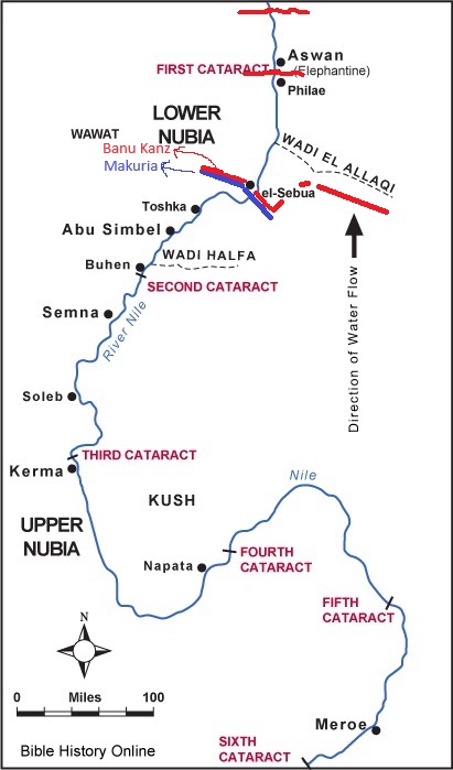
Areas controlled by the Banu Kanz in 1337.
Map-of-Ancient-Nubia.jpg
 
Last edited:
nice map, id make the Jaffa peninsula in the center of the location, to me it looks like its on the very edge. also seems to me Ramla is in the Jaffa location
I modelled the Ramle and Jaffa borders on early 19th c. district lines, w/ Lydda being part of Jaffa. Ramle according to the map I referenced would be just part of the location, but since both Ramle and Jaffa are too important to not include, I thought it important to have both represented, with the towns very close to the border rather than Jaffa representing Lydda and Jaffa *and* Ramle
 
I have to disagree with the naming of Bedouin culture (the one north of Hejaz), while yes Bedouin is a culture, but the name means pastoral or Nomadic, in this case, its a way of life. A Hejazi or Najdi can be Bedouin or not (being a city dweller). Separating Bedouin from the other Arabian cultures paints a picture that Hejazis or other Arabians as not "Bedouin" while many are.
 
  • 3
Reactions:
Areas controlled by the Banu Kanz in 1337.
View attachment 1165681
No evidence for the Banu Kanz controlling the Nile Valley south of Aswan in 1337. As late as 1365 al-Maqrizi reported that they ruled over Aswan, the western oases and the desert towards Aydhab. They didn't take control of dar al-kunuz until they were ousted from Aswan later that year. The first source that locates them south of Aswan is Ibn Khaldun.
 
No evidence for the Banu Kanz controlling the Nile Valley south of Aswan in 1337. As late as 1365 al-Maqrizi reported that they ruled over Aswan, the western oases and the desert towards Aydhab. They didn't take control of dar al-kunuz until they were ousted from Aswan later that year. The first source that locates them south of Aswan is Ibn Khaldun.
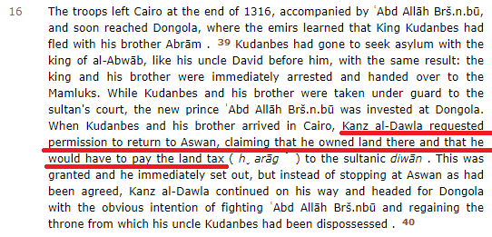
It seems that the Mamluks lost power over Aswan sometime in 1316, because it was only sometime in 1366 that they restored the position of governor of Aswan.
The Banu l-Kanz were once again in charge of protecting the routes and politically dominated the region. The city, formerly a Shia majority, soon returned to Sunnism. Under the Mamluks the aggressive policy against Nubia was resumed, and in 1273 and 1275 the Nubians made counter-attacks on Aswan. The Mamluks tried to install a Muslim prince in Dongola with the help of the Banu l-Kanz and succeeded in 1316 . The various military expeditions that left Aswan in these years encouraged the local economy a little. But when the Banu l-Kanz through clever marriage connections, became sultans of Nubia, they were not very favorable to the Mamluks. It seems that the Banu l-Kanz then ruled the city of Aswan since no Mamluk governors are mentioned there (and if the Banu l-Kanz were there they exercised a de facto hegemony). The city followed its decline and the capital and activity remained in Kuş.

In 1365/1366 the Kayaite tribes of Upper Egypt or Said, including the Banu l-Kanz , revolted and the southern routes to Aydhab could not be used; then the Mamluk government restored the position of governor of Aswan or Said (1366) and stripped the Banu l-Kanz of their fiefdom. The war between Mamluks and the so-called Kenuz (the Kanz) was bloody; the first Mamluk governor committed unnecessary cruelties and Aswan was occupied by his soldiers and plundered. In 1385 the Banu l-Kanz or Kenuz attacked Aswan and put the Mamluk governor to flight; in 1396 it was once again conquered and plundered by the Mamluks; the last governor of Aswan was appointed in 1399 and then the serious crisis of the Mamluk state with a plague and military and political conflicts, finally left Aswan in the hands of the Banu l-Kanz.
 
You should stop relying on random Wiki entries. This paper by Robin Seignobos is the definite source for the Banu Kanz in the early 14th century.
I know the website you gave me.

It seems that Kanz al-Dawla lost power over Makuria to Siti who is a Christian and probably rules Makuria in 1337, so probably by then Banu kanz had retreated north.

A quote confirming that Banu kanz members had influence in Aswan.
banu kanz.png
 
Cyrenaica and boundary to Mamluks (Egypt)

According to Ahmad bin Fadlallah al-Umari's manual of administration (Tarif bil-Mustalah as-Sharif) written between 1340 and 1349 the most Western border location of Mamluk Egypt was al-'Akaba, modern Sallum resp. the ancient Catabathmus magnus/maior.

'The Mamluk sultans had to send their armies from time to time to drive the tribes of Cyrenaica from Egyptian territory, and two of them tried to bring these tribes to recognize their authority [i.e. Baibars (1260-77) and al-Mansur Qalawun (1279-90)]. […] it appears that the Mamluks were unable to develop any connection with Cyrenaica beyond ephemeral alliances with specific tribal chiefs. In Cyrenaica […] the tribes remained in control of their respective districts, and when they yielded to authority it was to a tribe stronger than themselves. For a greater part of the four centuries from the eleventh to the end of the fifteenth the Hib tribe exercised control over the other tribes in Cyrenaica […].' (A History of the Magrib, p. 190)
 
Last edited:
  • 1
Reactions:
Some notes to raw materials in Egypt:

During rule of Mamelukes grain (wheat) was the most important produced good in Egypt. Cotton had to be imported. Cultivation of cotton was of no importance until 19th century in Egypt. The cotton that was cultivated in minor quantity from the 18th century was of bad quality. In 1821 a new brand was introduced 'that soon became famous world-wide for its long staple, something that enhanced its competitiveness in European, and especially British, markets owing to its suitability for textile manufacturing'. Only then 'cultivation was expanded to cover huge tracts of land'. (Source: Cambridge History of Egypt, Volume 2, p. 162)

Thesis regarding agriculture in Egypt during Mameluke rule (contains analysis of every province!): http://static1.squarespace.com/static/556c9a19e4b0a58d63e1cc6c/t/55f2d885e4b07f7a594184c7/1441978501003/Quickel - 2015 - MA Thesis.pdf

An article regarding sugar in Egypt: http://mamluk.uchicago.edu/MSR_VIII-2_2004-Tsugitaka.pdf

Sugar production collapsed as part of the general economical decline that was caused by the Black Death in mid-14th century (for some centuries sugar had to be imported) and recovered by the end of 16th century (https://books.google.de/books?id=7HTqyTrJmVQC&pg=PA301#v=onepage&q&f=false).

'Up to 1800, Egypt’s agriculture was mostly confined to winter crops, such as wheat, barley, beans, and Egyptian clover, due to its reliance on the Nile inundation in August. Summer crops, such as short-staple cotton, sugarcane, and rice, were limited to farms that were close to the Nile River and could thus have water throughout the whole year.' (http://www.parisschoolofeconomics.eu/docs/ydepot/seance/257_SAL2015COT.pdf, p. 6)

'in Egypt cotton cultivation did not begin to play an important role in the country’s economy until the beginning of the nineteenth century.' 'Egypt was not a major exporter of the cotton until the 1820s. Before that it was an important consumer of the raw fibre, imported from Syria and other areas of the Ottoman Empire.' (https://apebh2012.files.wordpress.com/2011/05/apebh-text-of-paper-panza.pdf, p. 4-5)

'Rather than supporting the central government in military aspects, Egypt provided large quantities of grain and tax revenue for the central government.' (http://www.rosetta.bham.ac.uk/issue15supp/gunes.pdf, p. 86)

'Flax of the highest quality was produced in many parts of Egypt, but it was from the regions of Middle Egypt, particulary the little-known village of Busir Quridis and its surrounding area, that most of the data furnished by the Geniza documents concerning the cultivation and commerce in flax derives.' (Source: International Trade and the Medieval Egyptian Countryside, by A. L. Udovitch)

Udovitch refers to the 11th century. But it seems still valid for later periods: 'Fayum was an important center for the planting of flax'. (Source: Artisan Entrepreneurs: In Cairo and Early-modern Capitalism (1600-1800), by Nelly Hanna, p. 108-109.)
 
States in Hejaz:

Emirate of Mecca (10th century - 1916/1925)

Extension:


'The territory traditionally under its direct control included the holy city of Mecca and its immediate hinterland, the nearby hill town of Ta'if, and the Red Sea port of Jedda. In addition, the sharifs often exercised a tenuous hold over certain tribal areas in the Sarat Mountains south of Ta'if, as well as the coastal plain south of Jedda, known as the Tihama.' (Richard T. Mortel: Taxation in the Amirate of Mecca during the Medieval Period, p. 1.)

The Emir of Mecca received sovereignty over Medina and Yanbu in 1482 by decree of Mamluks who get more and more influence in this region since they came to power in Egypt. (Richard T. Mortel: The Ḥusaynid Amirate of Madīna during the Mamlūk Period.)

Economy:

'The amirate was poor in resources. Industry was extremely limited, while agriculture was practised on a very small scale. As a consequence, Mecca was largely dependent on the regular import of basic foodstuffs, and especially cereal grains, from the Yemen, East Africa, and, principally, Egypt. Trade, on the other hand, was the economic activity par excellence in the amirate, being centred in Mecca and Jedda. (Richard T. Mortel: Taxation in the Amirate of Mecca during the Medieval Period, p. 1.)

During the Fatimid and Ayyuibid eras, Jedda gradually developed into a commercial entrepot of signal importance on the maritime trade route linking the ports of the west coast of India with Egypt, and ultimately, the whole Mediterranean basin. The volume of this trade increased dramatically during the eighth/fourteenth century, in the Mamluk period.' (ibid.)

'[The] primary source of income for the sharifs was the revenue derived from taxation. Although taxation in Mecca took a variety of forms, the most important one was the levy on merchandise arriving in Mecca and Jedda from the Yemen and India [...].' (ibid.)


Emirate of Medina (10th century - 1482)

The Emirate of Medina was established in 10th century and was ruled like Mecca by sharifs. Both emirates had a tense relationship to each other. Both sought to unite the Holy Cities under their rule. Medina came under the permanent rule of Emir of Mecca in 1482. (Richard T. Mortel: The Ḥusaynid Amirate of Madīna during the Mamlūk Period.)


Emirate of Yanbu (? - 1482)

Another Sharifian Emirate was that of Yanbu and took part in the Mecca-Medinian-struggle as variable ally. Yanbu came under the permanent rule of Emir of Mecca in 1482. (Richard T. Mortel: The Ḥusaynid Amirate of Madīna during the Mamlūk Period.)
 
Last edited:
  • 2Like
  • 1
Reactions:
The Mamluk sultans had to send their armies from time to time to drive the tribes of Cyrenaica from Egyptian territory, and two of them tried to bring these tribes to recognize their authority [i.e. Baibars (1260-77) and al-Mansur Qalawun (1279-90)]. […] it appears that the Mamluks were unable to develop any connection with Cyrenaica beyond ephemeral alliances with specific tribal chiefs. In Cyrenaica […] the tribes remained in control of their respective districts, and when they yielded to authority it was to a tribe stronger than themselves. For a greater part of the four centuries from the eleventh to the end of the fifteenth the Hib tribe exercised control over the other tribes in Cyrenaica […].' (A History of the Magrib, p. 190)
You posted interesting information here.
What then should have been the status of Cyrenaica in 1337? Should it be divided between tribes or be one country with areas with high autonomy?
Should the country be a tributary of the Mamluks or a vassal?


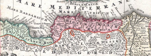
I think the country could be called Barka, Barqah Just like on this map.
The map is in Latin
And the inscription on Cyrenaica means that there is some Barca Kingdom there.

main-qimg-66c266a0eb35bc3fdb5b7f08a71b8fc2-pjlq.jpg
 
  • 1Like
Reactions:
You posted interesting information here.
What then should have been the status of Cyrenaica in 1337? Should it be divided between tribes or be one country with areas with high autonomy?
Should the country be a tributary of the Mamluks or a vassal?


I think the country could be called Barka, Barqah Just like on this map.
The map is in Latin
And the inscription on Cyrenaica means that there is some Barca Kingdom there.

View attachment 1166157
Firstly I want to make following addition:

'In Cyrenaica the nominal authority of the Mamluks was replaced by nominal sovereignty of the Ottomans after the latter conquered Egypt in 1517. For over a century-and-a-half afterwards nothing is known about the political structure of this province, except that it remained the domain of tribalism. Two energetic pashas of Tripoli of the Saqizli family [...] made the Cyrenaican tribes aware of Ottoman power and recognize the sovereignty of the sultan but without imposing Ottoman control on them. Muhammad [Mehmed] Saqizli sent an expedition which defeated a local chief who from his base in Jabal al-Akhdar controlled Barqa and had several of the tribes in the neighbourhood recognize him as ruler. [...].' (A History of the Maghrib, p. 195)

To summarize: Cyrenaica was de facto ruled by tribes until mid 17th century. This rule had to be ended by force. So I would propose to represent Cyrenaica as a separate political entity. I'm not sure if there is any benefit to divide Cyrenaica into many tribal entities.
 
  • 2
  • 1Like
Reactions: