• We have updated our Community Code of Conduct. Please read through the new rules for the forum that are an integral part of Paradox Interactive’s User Agreement.

Tinto Maps #4 - 31th of May 2024 - Poland, Ruthenia, Baltic

Hello everyone, and welcome to the fourth Tinto Maps! The feedback that we've received so far has been great, and there will be news soon regarding the map fixes that we've already done.

This week we are showing you Poland, Lithuania, Ruthenia, and the Baltic region. Let’s check it with no further ado:

Countries
Countries.jpg

A bigger picture of what’s going on in this region today, as we hadn’t shown it entirely before. To the west, the Kingdom of Poland is ruled by Casimir III of the House of Piast. It is not a completely unified kingdom, as there are several powerful vassals under him, most of them also Piasts themselves.

To the east, the Duchy of Lithuania is ruled by Gediminas, who has greatly expanded the influence of the country into Russian lands (side note: Gediminas entitled himself in his diplomatic correspondence ‘king’, but was considered by the Pope ‘king or duke’, and the title of Grand Duke wouldn’t be formally adopted until later [most likely replicating the Russian title ‘Grand Prince’]. That’s why Lithuania starts as a Duchy, although it will have an event that would make it possible to adopt the dynamic country name of ‘Grand Duchy’).

To the south, the principalities of Kyiv and Galicia-Volhynia have recently fallen under foreign influence, the first ruled by Theodor, brother of Gediminas of Lithuania; and the second by Yuri II, also from the Piast dynasty.

To the north, the Teutonic and Livonian Orders, which conquered the lands of Prussia and Livonia a century ago, are at war against Poland and Lithuania, after a long-established rivalry.

Also, a side note: we will talk about Moldavia in the Tinto Maps devoted to the Carpathian region, as it’s currently in a ‘placeholder’ spot.


Diplomacy.jpg

A new map mode, the Diplomatic one! The game starts with an ongoing war between Poland, Lithuania, and their respective vassals, on one side, and the Teutonic and Livonian Orders, and Bohemia and its vassals, on the other.

Locations
Locations.jpg

Here you have the locations of Poland, Lithuania, Ruthenia, and the Baltic region. Some issues that have already been reported by our Polish coworkers are the inconsistencies in the location naming in Polish (we’ll use proper Polish letters more thoroughly), and we’ve also started to review both the Polish and Baltic locations based on the early feedback you gave us. Oh, also, the Vistula and Curonian Lagoons missing is a bug, we’ll properly re-add them while doing the map review.

Provinces
Province.jpg

Any suggestions for provincial naming are pretty welcome, as in the last DD!

Terrain
Climate.jpg

Topography.jpg

Vegetation.jpg


Cultures
Cultures.jpg

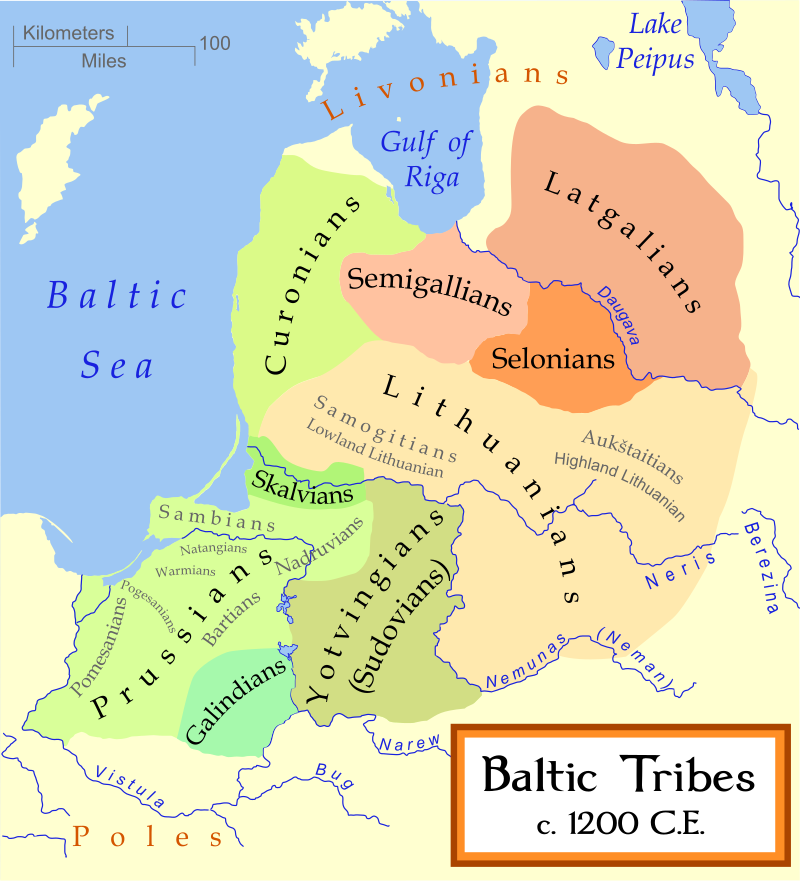
The Baltic lands have an interesting mix of different cultures. ‘Western Baltic’ culture represents the people speaking a West Baltic language (Old Prussians, Yotvingians, Curonians, etc.), while ‘Prussian’ is the culture of the German settlers of that area; on that style, we have a ‘Baltic German’ culture in the lands of Livonia and Estonia that also got settled by German-speaking people. The divide between Polish, Ruthenian, and Aukstaitian might be too deep, so we will most likely add a bit more mixed situation in the borders between these cultures.

Religions
Religions.jpg

A region with a more interesting religious setup! Apart from the Catholic-Orthodox divide, you can also see the Romuva religion, which was a hot topic in 1337 (shall the Dukes of Lithuania convert to Catholicism, or stay Pagan?). Red stripes to the north are other Animist populations. Also, disregard the Sunni region to the southeast, as we have to review all the pops of the Pontic Steppes, as well.

Raw Goods
Raw Goods.jpg

From the distribution of the materials, maybe a couple of things might catch your eye. The first is that there’s an Amber good present on the shores of the Baltic Sea. The second is that the Tatra Mountains, in Slovakia, have a bunch of precious metals, which makes them a very interesting area to exploit and develop.

Population
Pops.jpg

Pops 2.png

The population of the region is divided into country and location views. Two notes: The total population of Estonia is not 711K people, that’s the total for its owner, Denmark. Second, we’ve read your feedback regarding the population map mode, and we’ll take a look at how to improve the visualization of the data, making it better for you.

EDIT: Markets
Markets.jpg

And that’s all for today! The region that we'll show next week is Italy! Cheers!
 
  • 212Love
  • 163Like
  • 10
  • 5
  • 4
  • 1Haha
Reactions:
Here are a few suggestions for improving the map:

1. Ruthenian culture should be divided into "White Ruthenian" for the lands of modern Belarus and "Ruthenian" for the territories of modern Ukraine.

2. Several locations within the Galicia-Volhynia should be named in Ukrainian rather than Polish at the start of the game:

Polish name - Ukrainian name
  • Rzeszów - Rashiv.
  • Przemyśl - Peremyshl.
  • Lubaczów - Liubachiv.
  • Chełm - Kholm.
  • Terebolwja (not even polish, should be Trembowla then) - Terebovl.

3. Some locations have city names that didn't exist before the 18th and 20th centuries.
  • Khmelnytskyi didn't have this name until 1954. Should be Proskuriv (ukr) or Płoskirów (pol).
  • Voznesensk was founded in 1795. There was a "Sokoly" settlement, which would be a better name for this location.
  • Nova Odesa was founded as village "Fedorovka" in 1776 and renamed in 1832. There was another settlement before called "Oleksiivske".
  • Kropyvnytskyi is a modern name of Yelysavethrad, founded as Fort St. Elizabeth in 1752. There was neither a city nor a village on this site, but in the 17th century there were Cossack settlements here. I propose to name this location "Inhul" as the local river's name.

4. Regarding the names of provinces:
  • Przemyśl and Chełm should be Peremyshl and Kholm.
  • Volhynia, Halychyna and Podolia are more suitable as names for areas. I suggest naming them Volodymyr, Halych and Proskuriv instead.
  • Yelanets is a small village with no historical value, while Chyhyryn is an old town that was once the capital of the Hetmanate. Therefore, I propose to rename the province from Yelanets to Chyhyryn.
  • Odesa was founded in 1794, so there is no reason to name province after it. I suggest to name it Yedysan instead (as this region called).
  • Ochakiv's name comes from the Achi-Kale fortress, which was renamed after the Turkish style in the 16th century. During the period of the Lithuanian principality, the city of Dashiv was mentioned on the site of Ochakiv, so I propose renaming the location and province in this way.
Hello everyone, and welcome to the fourth Tinto Maps! The feedback that we've received so far has been great, and there will be news soon regarding the map fixes that we've already done.

This week we are showing you Poland, Lithuania, Ruthenia, and the Baltic region. Let’s check it with no further ado:

Countries
View attachment 1141116
A bigger picture of what’s going on in this region today, as we hadn’t shown it entirely before. To the west, the Kingdom of Poland is ruled by Casimir III of the House of Piast. It is not a completely unified kingdom, as there are several powerful vassals under him, most of them also Piasts themselves.

To the east, the Duchy of Lithuania is ruled by Gediminas, who has greatly expanded the influence of the country into Russian lands (side note: Gediminas entitled himself in his diplomatic correspondence ‘king’, but was considered by the Pope ‘king or duke’, and the title of Grand Duke wouldn’t be formally adopted until later [most likely replicating the Russian title ‘Grand Prince’]. That’s why Lithuania starts as a Duchy, although it will have an event that would make it possible to adopt the dynamic country name of ‘Grand Duchy’).

To the south, the principalities of Kyiv and Galicia-Volhynia have recently fallen under foreign influence, the first ruled by Theodor, brother of Gediminas of Lithuania; and the second by Yuri II, also from the Piast dynasty.

To the north, the Teutonic and Livonian Orders, which conquered the lands of Prussia and Livonia a century ago, are at war against Poland and Lithuania, after a long-established rivalry.

Also, a side note: we will talk about Moldavia in the Tinto Maps devoted to the Carpathian region, as it’s currently in a ‘placeholder’ spot.


View attachment 1141098
A new map mode, the Diplomatic one! The game starts with an ongoing war between Poland, Lithuania, and their respective vassals, on one side, and the Teutonic and Livonian Orders, and Bohemia and its vassals, on the other.

Locations
View attachment 1141100
Here you have the locations of Poland, Lithuania, Ruthenia, and the Baltic region. Some issues that have already been reported by our Polish coworkers are the inconsistencies in the location naming in Polish (we’ll use proper Polish letters more thoroughly), and we’ve also started to review both the Polish and Baltic locations based on the early feedback you gave us. Oh, also, the Vistula and Curonian Lagoons missing is a bug, we’ll properly re-add them while doing the map review.

Provinces
View attachment 1141101
Any suggestions for provincial naming are pretty welcome, as in the last DD!

Terrain
View attachment 1141106
View attachment 1141108
View attachment 1141109

Cultures
View attachment 1141110
The Baltic lands have an interesting mix of different cultures. ‘Western Baltic’ culture represents the people speaking a West Baltic language (Old Prussians, Yotvingians, Curonians, etc.), while ‘Prussian’ is the culture of the German settlers of that area; on that style, we have a ‘Baltic German’ culture in the lands of Livonia and Estonia that also got settled by German-speaking people. The divide between Polish, Ruthenian, and Aukstaitian might be too deep, so we will most likely add a bit more mixed situation in the borders between these cultures.

Religions
View attachment 1141112
A region with a more interesting religious setup! Apart from the Catholic-Orthodox divide, you can also see the Romuva religion, which was a hot topic in 1337 (shall the Dukes of Lithuania convert to Catholicism, or stay Pagan?). Red stripes to the north are other Animist populations. Also, disregard the Sunni region to the southeast, as we have to review all the pops of the Pontic Steppes, as well.

Raw Goods
View attachment 1141113
From the distribution of the materials, maybe a couple of things might catch your eye. The first is that there’s an Amber good present on the shores of the Baltic Sea. The second is that the Tatra Mountains, in Slovakia, have a bunch of precious metals, which makes them a very interesting area to exploit and develop.

Population
View attachment 1141117
View attachment 1141127
The population of the region is divided into country and location views. Two notes: The total population of Estonia is not 711K people, that’s the total for its owner, Denmark. Second, we’ve read your feedback regarding the population map mode, and we’ll take a look at how to improve the visualization of the data, making it better for you.

EDIT: Markets
View attachment 1141180
And that’s all for today! The region that we'll show next week is Italy! Cheers!

Hello everyone, and welcome to the fourth Tinto Maps! The feedback that we've received so far has been great, and there will be news soon regarding the map fixes that we've already done.

This week we are showing you Poland, Lithuania, Ruthenia, and the Baltic region. Let’s check it with no further ado:

Countries
View attachment 1141116
A bigger picture of what’s going on in this region today, as we hadn’t shown it entirely before. To the west, the Kingdom of Poland is ruled by Casimir III of the House of Piast. It is not a completely unified kingdom, as there are several powerful vassals under him, most of them also Piasts themselves.

To the east, the Duchy of Lithuania is ruled by Gediminas, who has greatly expanded the influence of the country into Russian lands (side note: Gediminas entitled himself in his diplomatic correspondence ‘king’, but was considered by the Pope ‘king or duke’, and the title of Grand Duke wouldn’t be formally adopted until later [most likely replicating the Russian title ‘Grand Prince’]. That’s why Lithuania starts as a Duchy, although it will have an event that would make it possible to adopt the dynamic country name of ‘Grand Duchy’).

To the south, the principalities of Kyiv and Galicia-Volhynia have recently fallen under foreign influence, the first ruled by Theodor, brother of Gediminas of Lithuania; and the second by Yuri II, also from the Piast dynasty.

To the north, the Teutonic and Livonian Orders, which conquered the lands of Prussia and Livonia a century ago, are at war against Poland and Lithuania, after a long-established rivalry.

Also, a side note: we will talk about Moldavia in the Tinto Maps devoted to the Carpathian region, as it’s currently in a ‘placeholder’ spot.


View attachment 1141098
A new map mode, the Diplomatic one! The game starts with an ongoing war between Poland, Lithuania, and their respective vassals, on one side, and the Teutonic and Livonian Orders, and Bohemia and its vassals, on the other.

Locations
View attachment 1141100
Here you have the locations of Poland, Lithuania, Ruthenia, and the Baltic region. Some issues that have already been reported by our Polish coworkers are the inconsistencies in the location naming in Polish (we’ll use proper Polish letters more thoroughly), and we’ve also started to review both the Polish and Baltic locations based on the early feedback you gave us. Oh, also, the Vistula and Curonian Lagoons missing is a bug, we’ll properly re-add them while doing the map review.

Provinces
View attachment 1141101
Any suggestions for provincial naming are pretty welcome, as in the last DD!

Terrain
View attachment 1141106
View attachment 1141108
View attachment 1141109

Cultures
View attachment 1141110
The Baltic lands have an interesting mix of different cultures. ‘Western Baltic’ culture represents the people speaking a West Baltic language (Old Prussians, Yotvingians, Curonians, etc.), while ‘Prussian’ is the culture of the German settlers of that area; on that style, we have a ‘Baltic German’ culture in the lands of Livonia and Estonia that also got settled by German-speaking people. The divide between Polish, Ruthenian, and Aukstaitian might be too deep, so we will most likely add a bit more mixed situation in the borders between these cultures.

Religions
View attachment 1141112
A region with a more interesting religious setup! Apart from the Catholic-Orthodox divide, you can also see the Romuva religion, which was a hot topic in 1337 (shall the Dukes of Lithuania convert to Catholicism, or stay Pagan?). Red stripes to the north are other Animist populations. Also, disregard the Sunni region to the southeast, as we have to review all the pops of the Pontic Steppes, as well.

Raw Goods
View attachment 1141113
From the distribution of the materials, maybe a couple of things might catch your eye. The first is that there’s an Amber good present on the shores of the Baltic Sea. The second is that the Tatra Mountains, in Slovakia, have a bunch of precious metals, which makes them a very interesting area to exploit and develop.

Population
View attachment 1141117
View attachment 1141127
The population of the region is divided into country and location views. Two notes: The total population of Estonia is not 711K people, that’s the total for its owner, Denmark. Second, we’ve read your feedback regarding the population map mode, and we’ll take a look at how to improve the visualization of the data, making it better for you.

EDIT: Markets
View attachment 1141180
And that’s all for today! The region that we'll show next week is Italy! Cheers!
 
Last edited:
  • 11Like
  • 5
  • 2
  • 2
Reactions:
We might have to add a few more Pagan pops there, aye.
If at possible, could the expansion of "Romuva" further north be avoided? Even currently the expansion to it for the Livs is questionable at best. Animist or mixed with Romuva if anything, but pure Romuva is a step way too far. If it seems too granular one or the other is fine for the Livs.

The Livonian Order although autonomous was not what I'd call independent, but for the sake of gameplay that will be fine, I guess.

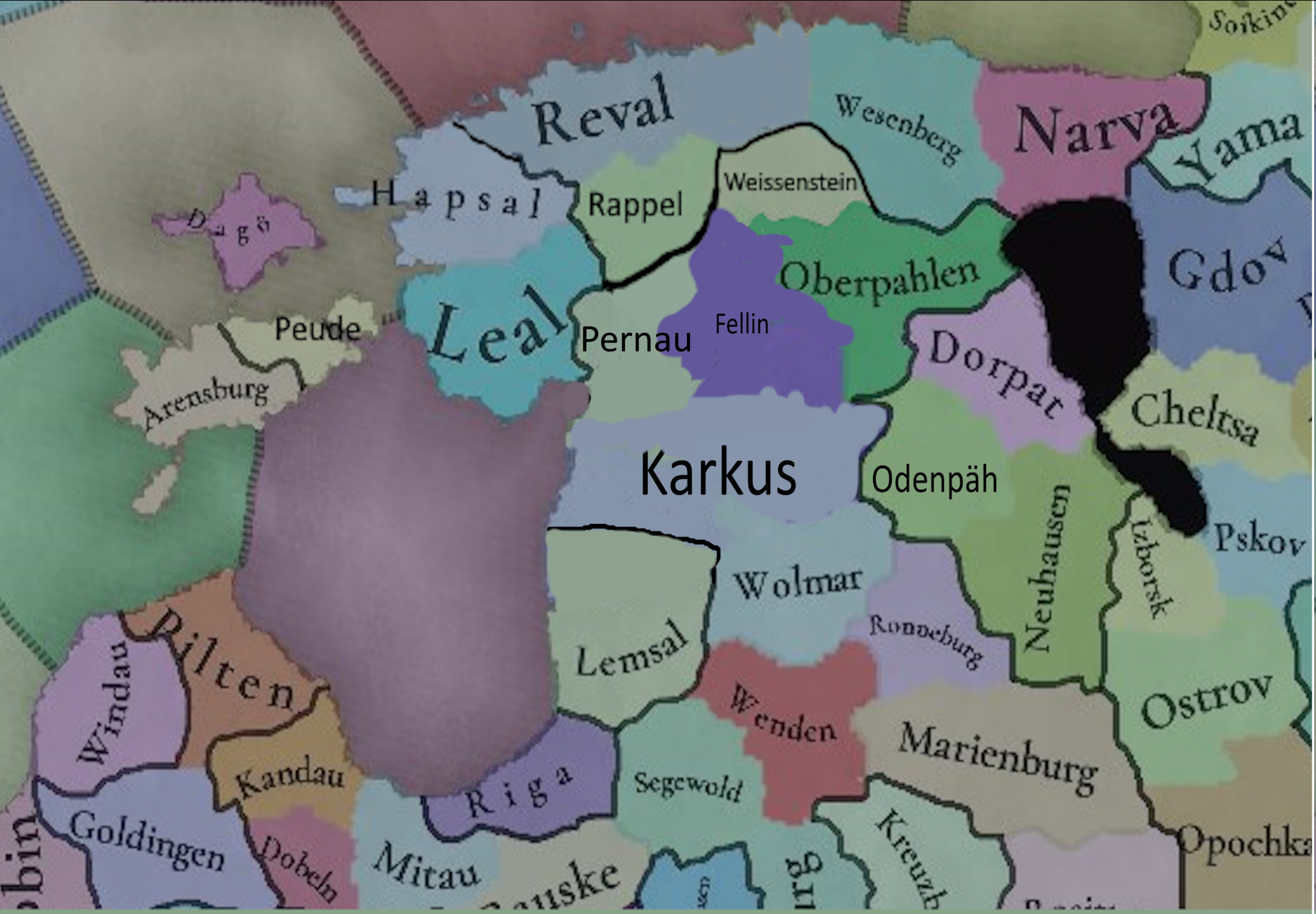
I have also slightly redrawn the location map for Northern Livonia/Estonia as that is what I feel most comfortable in recognising.
1717165599960.png

Redraw reasoning
Karkus - seemed to not contain Karkus much like Valjala seemed to not contain Valjala
Lemsal - reached further north historically
Rappel - removing parts of Jerwen
Weissenstein - did not historically reach the coastline with that being covered by Reval and Wesenberg. Additionally at this point the location was for all intents and purposes under the control of the order rather than Denmark.
Fellin - historically bordered Weissenstein and was not that far south with that instead being covered by Karkus
Pernau - way way too big from a historic perspective

Also a few rename suggestions and reasoning behind the renames-

Jarva to Rappel - the current Jarva ought to be renamed to Jerwen if it is to be kept, but the current one is a weird mix of Rappel and south Jerwen.
Valjala to Peude - the actual stronghold that the province is named after seems to be in the Arensburg location. Also the Livonian Order stronghold on the island was Peude, moving to Soneburg after the 1343 St George's Night uprising.
Walk to Odenpäh - whilst Walk would become an important city later on - 1419, in the current time the region would arguably more be dominated by the nearby castle in Odenpäh.

The Bishopric of Ösel to that of Ösel-Wiek
Pärnu on the province map to either Pernau or perhaps Ösel-Wiek. The current Pärnau is a misfit either way

Hope this is of some help
 
  • 7Like
  • 3
Reactions:
Hey PDX Tinto, loving the Map updates and the totally unknown game that they relate to.

Thought that, as we are now in a region that would employ it, how flexible will place names be. By this I mean what encoding will be allowed? Will more of unicode be allowed in this game?

So using ç, ñ, the thorn, æ, and others for example, as well as other, non Latin base, alphabets in the base English encoding?

Looking forward to seeing Italy next week, keep on with your impressive work :).
The encoding of Project Caesar is very, very flexible.
 
  • 32Like
  • 10Love
  • 7
Reactions:
There is little historical data on Severian culture, but great to see it on the map. I'd suggest some adjustments:

a) Population figures in those locations (as well as in the whole Wild Fields area) seem too high, there was a long process of resettlement from the North and West during the game time period, with not very numerous locals being gradually assimilated.

b) This culture should probably extend further south, to cover area around Chernihiv.
 
  • 1
  • 1Like
Reactions:
Is there any reason Estonia isn't pagan or atleast have considerable pagan minorities?

There would be an uprising not long after game start and the natives renounced Christianity.
The natives did not renounce Christianity with that uprising but renounced the ones ruling over them, because of how badly they were treated, and wanted someone better to rule over them. It had nothing to do with religion.
 
Is green stripes( up to Danzig) in the diplomacy mapmode a hint to upcoming war goals and peace deals system?
No, it's Polish cores.
 
  • 31Like
  • 20
  • 3Haha
  • 2Love
Reactions:
In my opinion border regions between cultures and religions should be mixed almost everywhere because people were moving and ideas (like religion) were spread for example by trade.

So will it be present in game by minorities on borders of cultures and religions?

Also will it be dynamic in sens that cultures/religions move even though borders?
 
  • 2Like
Reactions:
Is ruthenian culture going to split into ukrainian and belarusian during the campaign?

If yes, are the pops going to instantly change culture at the click of a button or are they going to slowly diverge, kinda like how assimilation works?

Is it going to be something that you can influence in some way? (Encouraging the fracture, discourage or even preventing it).
 
  • 3Like
Reactions:
As a lithuanian I don't feel that separating lithuanians to samogitians and aukstaitians is really a good choice. As it basically means lower and higher lithuanians (as in terrain). But if you really need to separate them it should be samogitians and lithuanians, as Lithuania is formed from "lithuanian's" tribe, not aukstaitians

And it should be Lyda instead of Lida if there are lithuanians as it's name is from "slash-and-burn" agriculture.
I'm personally fine with the Samogitians being a separate culture because they historically were quite rebellious even against Lithuania in this period (like a pagan revolt in a few parishes in 1418, or the more well known 1440 rebellion that led to the creation of the title "Duke of Samogitia" to strengthen their autonomy, hence the later full title "Grand Duke of Lithuanians, Samogitians and Ruthenians"). Besides, in this time period Samogitians spoke a lot more distinct dialect than they do today, closer to Western Baltic.

This legally distinct not-EU5 project ( :) ) also divides cultures really liberally. French is divided to what, 15 cultures or something?
 
  • 5Like
  • 1
Reactions:
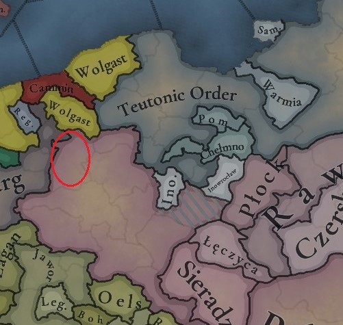
1.This province
Countries.jpg
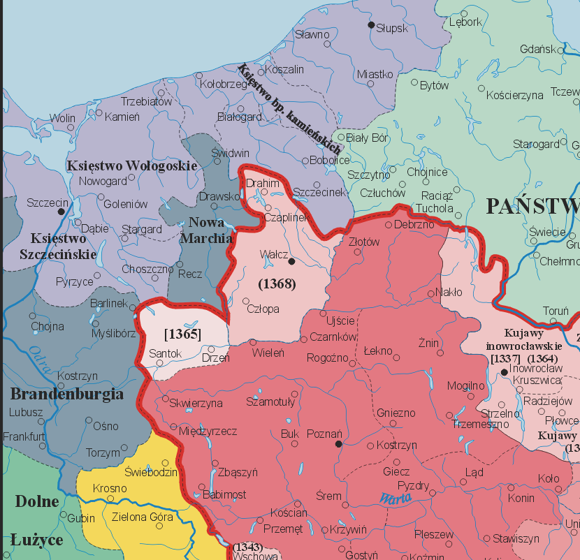
should be a part of Brandenburg. It became a part of Poland in 1368 as a part of agreement between king Kazimierz Wielki and Otton V
2. How do you decide where to put impassable mountains? I wonder if Sudetes mountains should be there.
3. Will there be a scripted event for peace between Poland and Bohemia?
4. How do you decide which city's name is going to a province? Because the province of Tarnów could be renamed to Wieliczka
Source:
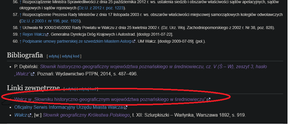
1. Source is in Polish:
Bez tytułu.png
that link at Wałcz wiki page in polish
also a map:
Polska_1333_-_1370.png

4. Tarnów was located in 1330 so it shouldn't be that important

Anyway great work guys! Keep it up!
 
Last edited:
  • 16Like
  • 3
  • 1
Reactions:
Will it be possible for the various ethnic religions like Paganism, Shamanism, even Judaism, to spread to pops outside of specific culture groups? It'd be pretty weird for people in France to be praising Perkūnas is all I'm saying. I imagine there should be some way to restrict those religious to specific culture groups for the most part.

Also, as stated, "Romuva" is a modern Lithuanian neopagan movement, you guys should just go with "Baltic Paganism" in abscence of a better name.

About cultures. I think that splitting the Lithuanians in two might be a bit unecessary. By contrast I think Western Baltic should probably be split between "Baltic Prussian" (in contrast with "German Prussian") and Curonian. Also do the Galindians, Sudovians, Scalovians, Semigalians and Selonians no longer exist at this time?

undefined

(Latgalians I'm pretty sure are just the ancestors of the Latvians, be free to correct me on that. Both were called "Letts" before the 19th century and still are in some languages)
While Samogitians didn't have their own language back then, they clearly had their own seperate identity from Lithuanians (Aukštaitians), so it's not wrong at all that they are a culture on their own.

Yes, Old Latgalians = Old Latvians.

Galindians can be merged with Prussians, that's not a problem, they were really close.

At least all of Latvia isn't Latvian, but Western Baltic should be divided into Prussian and Curonian and should not include Semigallia as they were Eastern Baltic like Latvians and Lithuanians (closer to the latter). We can live without Selonians, they were the first to be assimilated into Latvians and Lithuanians.

Yatvingians are missing from the map and some of their lands are even shown as Polish, even now Lithuanians (most likely assimilated Yatvingians) are living there.

South Estonian should be a culture on its own, too, seperate from Estonian.

I will try to make a more detailed post later, as I'm writing all of this in hurry.
 
  • 8
  • 7Like
  • 2Love
  • 2
Reactions: