• We have updated our Community Code of Conduct. Please read through the new rules for the forum that are an integral part of Paradox Interactive’s User Agreement.

Tinto Maps #9 - 5th of July 2024 - Carpathia and the Balkans

Greetings, and welcome to another Tinto Maps! This week we will be taking a look at Carpathia and the Balkans! It will most likely be an interesting region to take a look at, with a lot of passion involved… So I’ll just make an initial friendly reminder to keep a civil discussion, as in the latest Tinto Maps, as that’s the easiest way for us to read and gather your feedback, and improve the region in a future iteration. And now, let’s start with the maps!

Countries:
Countries.png

Carpathia and the Balkans start in a very interesting situation. The Kingdom of Hungary probably stands as the most powerful country in 1337, but that only happened after the recovery of the royal power enforced by Charles I Robert of the House of Anjou, who reined in the powerful Hungarian nobility. To the south, the power that is on the rise is the Kingdom of Serbia, ruled by Stefan Uroš IV Dušan, who has set his eyes on his neighbors to expand his power. The Byzantine Empire, meanwhile, is in a difficult position, as internal struggles ended in Andronikos III being crowned sole emperor, at the cost of dividing the realm; both Serbia and Bulgaria have in the past pressed over the bordering lands, while the Ottomans have very recently conquered Nicomedia. The control over the Southern Balkans is also very fractioned, with a branch of the Anjou ruling over Albania, the Despotate of Epirus under the nominal rule of Byzantium as a vassal, Athens, Neopatria and Salona as vassals of the Aragonese Kings of Sicily, Anjou protectorates over Achaia and Naxos, and only nominal Byzantine control over Southern Morea. It’s also noticeable the presence of the Republics of Venice and Genoa, which control several outposts over the Adriatic and Aegean Seas. A final note: in previous maps, Moldavia was shown in the map, but we’ve removed it from it, and it will most likely spawn through a chain of events in the 1340s.

Dynasties:
Dynasties.png

The House of Anjou rules over Naples, Hungary, Albania, Achaia, and Cephalonia; they’re truly invested in their push for supremacy over the region. Apart from that, each country is ruled by different dynasties, except for Athens and Neopatria, ruled by the House of Aragón-Barcelona.

Locations:
Locations 1.png

Locations 2.png

Locations 3.png

Locations 4.png
This week we’re posting the general map of the region, along with some more detailed maps, that can be seen if you click on the spoiler button. A starting comment is that the location density of Hungary is noticeably not very high; the reason is that it was one of the first European maps that we made, and we based it upon the historical counties. Therefore, I’m already saying in advance that this will be an area that we want to give more density when we do the review of the region; any help regarding that is welcome. Apart from that, you may notice on the more detailed maps that Crete appears in one, while not being present in the previous one; because of the zooming, the island will appear next week along with Cyprus, but I wanted to make an early sneak peek of the locations, given that is possible with this closer zoom level. Apart from that, I’m also saying in advance that we will make an important review of the Aegean Islands, so do not take them as a reference for anything, please.

Provinces:
Provinces.png

Provinces! Nothing outstanding to be commented on here; as usual, we’re open to any feedback regarding them.

Terrain:
Climate.png

Topography.png

Vegetation.png

Terrain! The climate of the region is mostly divided between Continental and Mediterranean, with some warmer and some colder regions. Regarding the topography, the Carpathian mountains are famously important and strategic, while the Balkans are a quite hilly and mountainous region, which is also greatly covered by woods and forests.

Cultures:
Cultures.png

Here comes the fun part of the DD: The cultural division of the Balkans! A few comments:
  1. Hungary is full of different minorities. Transylvania, especially, is an interesting place: there we have a mix of ‘Hungarians’, ‘Transylvanians’ (which are the Romanian-speaking inhabitants of the region), ‘Transylvanian Germans’, and ‘Szekely’ people.
  2. We have divided the Southern Slavic-speaking region into their dialectal families of Slovene, Croatian, Bosnian, and Serbian.
  3. The Southern Balkans are mostly divided among Bulgarian, Albanian, and Greek cultures.
  4. We’re also portraying plenty of other cultures, such as Dalmatians, Aromanians, Sclavenes, Arvanites, Cumans, Jasz, or Ashkenazi and Romanyoti Jews.

Religions:
Religion.png

This one is also interesting. Apart from the divide between Western Catholicism and Eastern Orthodoxy, we have the Krstjani in Bosnia, Bogomils (the pink stripes both in Bosnia and Macedonia), and Paulicians in Thrace. The Jewish populations do not pass the threshold percentage to appear on the map, but there are plenty of communities across the region.

Raw Materials:
Raw Materials.png

The materials of the region. Something very noticeable is the richness of minerals, with plenty of Iron, Copper, Tin, Lead, Gold, and Silver. Specifically, Slovakia is very rich, and you definitely want more settlers to migrate to the region, and exploit its resources. The region is also very rich in agricultural resources, as you can see.

Markets:
Markets.png

The region is mostly divided among four markets: Venice, Pest, Ragusa and Constantinople.

Country and Location population:
Population 1.png

Population 2.png

Population 3.png

Population 4.png
Country and location population (which I’ve also sub-divided, and is under the Spoiler button).

And that’s all of today! I hope that you find the region interesting; we certainly think that it is. Next week we will go further south, and we will take a look at the Syrian Levant and Egypt. Cheers!
 
  • 193Like
  • 69Love
  • 7
  • 4
  • 3
  • 1Haha
Reactions:
Not only Hungary and vicinity, there were some rather fervent discussions about other stuff too. Albania, the Serbian-Bulgarian-Byzantine border, the Bosnian-Croatian border, Moldavia, the density/scarcity of impassables, the Bosnian culture and church, and probably many more I currently can't recall. Sure, Hungary might need the most work, but some improvements can be done elsewhere too. According to my current estimation (based on publication dates and thread length), the review will be posted on November 7th (+/- 2 days). That's exactly a month longer than the total wait for the Poland Feedback was.
If I may, a familiar quote: "És ezt miből számolta ki?"
 
  • 8Haha
  • 1
Reactions:
Albania

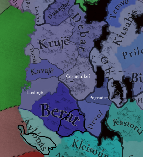
So I'm trying to make sense of what was coming on in that fabled land in 1337, but there is a lot of conflicting information; I was trying to stick something together from earlier suggestions in this thread and from what I've read on Wikipedia. I am not an expert on Albania and might be wrong.

Locations

I only added two locations here, Pogradec and Lushnjë, mostly to try to follow river borders.
Pogradec was under Gropa control, and I based its southern border on the river Devoll which formed the border between the Muzaka and Gropa lands.
Lushnjë was split off of the parts of Kavajë that were South of the river Shkumbin (I did not follow the flow of the river pixel perfect here, sorry), and represents the area of Myzeqe between the Shkumbin and Seman rivers, but I have also granted it a corridor to the Vjosa river (which may or may not be accurate).
I also adjusted the remaining parts of Kavajë to include the actual area of the town.
Çermenikë
is a suggested alternative name for Elbasan. Elbasan was founded later, by the Ottomans, so instead I would suggest using this name, which was also the seat of an Orthodox and later a Catholic diocese.

View attachment 1195473

Countries


This part is very problematic, due to the scarcity of information on this topic, and even the data we have is contradicting eachother.

Kingdom of Albania/Duchy of Durazzo: reduced to only the location of Durazzo
Thopia: controls Krujë and Kavajë; it is also possible that Kavajë could be controlled by the Matarangas. May also be called the County of Mat
Mataranga: they controlled lands around the Karavasta lagoon in Myzeqe both before and after the start date, but I did not find evidence of them in 1337. Nevertheless I couldn't find concrete evidence for any major country permanently occupying this location in 1337 either; Andronikos III did supposedly wage a punishing war against the tribes in Central Albania, but it seems to not have been an occupation or annexation of those lands but rather some light punishing, at least that's what it appears like for me. The Matarangas swore (nominal) allegiance to the Angevins, or were in a coalition with them.
Muzaka: during the reign of Andrea II, controls Berat and Devoll atm. He does seem to have served the Angevins, and had titles such as Marshal of Albania. An earlier suggestion in this thread suggested making the Muzaka principality a Byzantine vassal, but I think their allegiance based on the limited sources I've read seems to have lied closer to the Angevin kings. They could also be independent and in an alliance or a Coalition with Durazzo. They could alternatively be called the Lordship of Berat
Valona: either under direct Byzantine control or under Epirus, I'm not sure, please someone correct me on this.
Gropa: similar case to the Matarangas; Ohrid and Pogradec were already under Gropa rule long before the start date and became an independent principality after it, but in 1337, I have no idea. As far as I know they also controlled Debar, but I chose not to depict that here. Their inclusion or noninclusion depends mostly on the gameplay design, I guess;

I also do not know where the area of Elbasan and Çermenikë belonged to, if it belonged to anyone. This map depicts it as already occupied by Serbia in 1334, so I went with that.

View attachment 1195475

This all may or may not be wrong, definitely feel free to correct me.
holy based dude basically did my job for me the only thing i would add is maybe more location density maybe Kruje can be split into two with the Tirana area being the second southern part although i dont think it would be called Tirana because tirana was founded later in history, but having an option to do it would be cool
 
  • 3Like
Reactions:
"Hungary" is not necessarily to be avoided; the current setup Tinto uses has "Hungary", "Slovakia", "Transylvania" and "Slavonia", and many of the so-far revealed geographical areas denote cultural-geographical divisions such as those (actually, most of them; Africa even has are names such as Akan and Kru). So for example Western Hungary for Transdanubia might work, also would Great Plains or the Pannonian Plains for its repective area (minus the Transdanubian parts of it), Slovakia can be called Northern Hungary or Northern Carpathians (or maybe Slovakia but that is also an anachronism), but if it was split into East and West (a common theme in its medieval and early modern macro-level subdivisions) it can also go by a bunch of alternative names for those two. Slavonia could and probably should be different than Transdanubia/Western Hungary. One possible source of additional possible are names is the areas of the dukátus, that of Bihar, Nyitra, and possibly Krassó, though the institution of these duchies didn't exist anymore by the 14th century...

All in all, there are plenty of possibilities and a dozen different permutations for the area setup, many different versions for different tastes; let's see what Tinto goes with from the existing proposals, I guess.


So you would say no Ohrid lordship vassal; so something like this?
View attachment 1195618


On another note; Krujë might be too large compared to the tiny neighbouring Durrës, so it may make sense to split it into two: Northern half (north of the Ishëm river and the Mat region) would stay Krujë, while southern half would either be Petrelë (site of earlier medieval castle built by Justinian), or Tirana (first mentioned in 1418 it seems); or maybe even Prezë (another castle).
View attachment 1195623
Maybe Berat can be split into another province in its far east? or maybe Avlonas could be split too? I think Gijorakaster should possibly be represented too. however this is pretty good density i would say
 
Last edited:
If I may, a familiar quote: "És ezt miből számolta ki?"
Poland TT: 58 pages until feedback
Time until feedback thread: 95 days
95 ÷ 58 = 1,6379310345

Carpathia-Balkans TT: 76 pages
76 × 1,6379310345 = 124,482758622
124 days from Jul 5 -> Nov 5
I expected some further pages until review, so I calculated with an extra 2 days min.
 
  • 4Haha
Reactions:
Poland TT: 58 pages until feedback
Time until feedback thread: 95 days
95 ÷ 58 = 1,6379310345

Carpathia-Balkans TT: 76 pages
76 × 1,6379310345 = 124,482758622
124 days from Jul 5 -> Nov 5
I expected some further pages until review, so I calculated with an extra 2 days min.
Not all pages feature feedback, though. Some feedback consists of big amounts of text. Other posts can be smaller. It's not really valid to calculate it like this. The rework done for Poland/Baltics was not just based off feedback, but also on new research the devs did.

Anyway, we'll see.
 
  • 1
Reactions:
Poland TT: 58 pages until feedback
Time until feedback thread: 95 days
95 ÷ 58 = 1,6379310345

Carpathia-Balkans TT: 76 pages
76 × 1,6379310345 = 124,482758622
124 days from Jul 5 -> Nov 5
I expected some further pages until review, so I calculated with an extra 2 days min.
My man, that is not how this works....
 
  • 1Like
Reactions:
If I may, a familiar quote: "És ezt miből számolta ki?"
Just tried to google translate it, google translate crashed. I knew Hungarian is a hard language to learn, but I didn't expect this.

There is essentially fervent discussions about everything in this topic. Often with contradictory opinions because we don't know what happened. See the Hungarian - Romanian discussion above. And this is not 'user level forum', but their entire histographies are completely different. The devs would likely have to compromise not to offend one of the sides too much. And this is not true only for Hungarian - Romanian discussions but for everything else in this region because it's..... the balkans!

So yes, it's going to be a long time before we get the Carpathia & Balkans feedback. More than usual. Combined with the fact that the average western-european knows more about northern eastern europe (ie Poland & Ruthenia) than the Balkans, it's possible the Balkan feedback map will also have serious issue, which will require the devs to either do a feedback of the feedback or say "fuck it, we'll leave it this way". I don't envy the guy in charge of the balkans.

There was a quote, I forgot who said it: "Canada has too much geography and too little history, and the Balkans have too little geography and too much history".
 
  • 3Like
Reactions:
It could be argued that Dragoș was native of Maramures.

View attachment 1200511

Bedohaza is actually the house of Dragos. They decided to convert to Catholisicm and magyarize after the Romanian nobility lost rights in Transylvania.
see: (such as the Hunyadi/Corvinus, Bedohazi)
View attachment 1200513


We do not know that. There is no direct written evidence of a large-scale Romanian (Vlach) migration into Transylvania during the medieval period, while contemporaries in the 1200 do not regard the Romanian (Vlach) as migrators. In fact, they almost unanimously say that that the Romanian (Vlach) are the leftovers from the Roman Empire.

Is there was indeed a large-scale Romanian (Vlach) migration into Transylvania, wouldn't it be reasonable to assume that at least 1 chronicler would mention that? Instead we have works such as the Russian Chronicle that says the opposite.

According to Jean W. Sedlar, the oldest extent documents from Transylvania, dating from the 12th and 13th centuries, make passing references to both Hungarians and Romanian Vlachs.

Meaning the oldest documents from Transylvania, make reference to both Hungarians and Romanians. There are no earlier documents for the Romanians in Transylvania because there are no earlier documents for the Hungarians in Transylvania as well.

Also according to Jean W. Sedlar, it cannot be ascertained from any extant documentary evidence how many Vlachs (Romanians) may have resided in Transylvania in the 11th century. The actual number of persons belonging to nationalities is at best guesswork, the Vlachs may have comprised 66% of Transylvania's population in 1241 on the eve of the Mongol invasion.

We already need to count a notably higher Romanian presence in Maramures.

View attachment 1200521

And regarding the first mention of Vlachs in Fehér County (Fagaras), is not a charter from the 1290s.

A royal charter from 1223 mentions that the land where the Carta monastery was founded was taken from the Vlachs (Romanians). The said monastery was finished in 1202. This implies that the Vlachs (Romanians) lived there, and the Hungarian authorities confiscated their lands and eventually built Carta monastery there who was finished in 1202.

Similar charters mentioning land taken from the Romanians exist for Zarand in 1318, Bihor in 1326 and Turda from 1342.

Regarding Vlach population in Transylvania:

...

I have no personal position in the Transylvania issue, nor ability to judge this information (so don't @ me on this lol)

But I do want to thanks Zeprion for the care put into this post, including outlining the general Romanian and Hungarian positions--and the sources each rely on. I found this to be quite nuanced and very informative.

I know that the Balkans have a regional reputation for divisiveness and demographic contention, but the effort invested in some of these posts (including Fehervari's, ArVass's and others') has been quite remarkable.

Given the quality of feedback the devs are receiving--no matter how long it takes them to digest it--I'm excited to see what the release map eventually looks like
 
  • 4Like
  • 1
Reactions:
Just tried to google translate it, google translate crashed. I knew Hungarian is a hard language to learn, but I didn't expect this.

There is essentially fervent discussions about everything in this topic. Often with contradictory opinions because we don't know what happened. See the Hungarian - Romanian discussion above. And this is not 'user level forum', but their entire histographies are completely different. The devs would likely have to compromise not to offend one of the sides too much. And this is not true only for Hungarian - Romanian discussions but for everything else in this region because it's..... the balkans!

So yes, it's going to be a long time before we get the Carpathia & Balkans feedback. More than usual. Combined with the fact that the average western-european knows more about northern eastern europe (ie Poland & Ruthenia) than the Balkans, it's possible the Balkan feedback map will also have serious issue, which will require the devs to either do a feedback of the feedback or say "fuck it, we'll leave it this way". I don't envy the guy in charge of the balkans.

There was a quote, I forgot who said it: "Canada has too much geography and too little history, and the Balkans have too little geography and too much history".
The quote translates as "and how did you calculate that?", it's a Hungarian inside joke to be short
 
  • 1Like
Reactions:
My man, that is not how this works....
Not all pages feature feedback, though. Some feedback consists of big amounts of text. Other posts can be smaller. It's not really valid to calculate it like this. The rework done for Poland/Baltics was not just based off feedback, but also on new research the devs did.
You will see! It's a 100% infallible big brain prediction:D
 
  • 3Haha
Reactions:
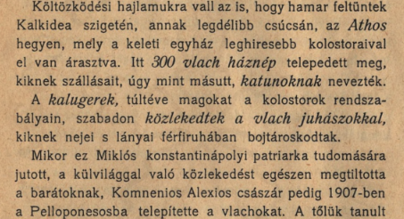
I'm currently exploring how and in what numbers could further pastorialists (tribesmen?) be added. 300 families on Mount Athos seems like an extreme claim though. Could it be possible that the text actually refers to all of the Chalkidiki Peninsula? I will try to look into where does this claim originates from, maybe that could help to clarify things.

From Az oláh Erdei paszornépről by János Földes:

1728677542219.png


"The fact that they appeared quickly is a testament to their tendency to move. On the island of Kalkidea, at its southernmost peak, Athos, a mountain with the most famous monasteries of the Eastern Church, is flooded. 300 Vlach households settled here,whose lodgings, like elsewhere, were called katuns."

The fact that he specifies Athos first, and underscores it by mentioning the famous monasteries there, before he mentioned numbers, makes me certain that it's infact just on the southern-most peak where Athos is, that would be home to 300 households/families/catuns. Also how its later mentioned that it was such a big problem, that Emperor Alexios had to expel them to Pellepones, and the wording that they quickly appeared and "flooded" the mountain.


That's right, but where did Dragoș come from? It could be argued that he came from Moldavia, although there's no definite proof of it. Still, it can be speculated that the Vlachs of Máramaros and vicinity came from Moldavia, not from the South directly.

Okay, reason with me here. If the Hungarian king desired to establish a march in Moldavia, why would he go through the bother of bringing someone from over there, over the mountains, make him a landed noble in either Giulești, Bedevlya or Khust, just to kick him back over the mountains to establish a march? Why uproot his power base, make him establish a new one, and then go back again, trying to build it up from scratch again?

If Dragoș was already in Moldavia, why not just cut to the chase?


Hungary wasn't an area dominated by nomads either, not in the past 300 years from the start date at least.

Let's be serious now. We agree that just 95 years before game start, the Mongols went by trying to tear down every building they got their eyes on, obliterating the settled populations in Hungary, Transylvania and everywhere they went in that campaign?

We also agree that they tried to do it once more 52 years before starting date, although not nearly as succesful at reaching Hungary proper, but they were still on the lands between the Danube and the Carpathians as well as the Carpathians and the Black Sea.

And before those, there were never a shortage of invasions either, be they Cuman, Avar, Hungarian, Hunnic.

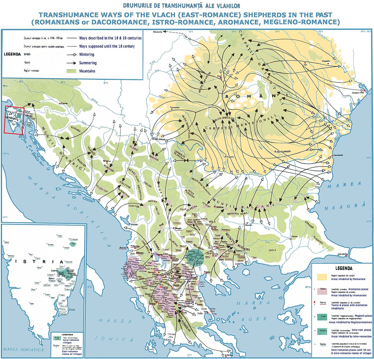
This was what I meant with the area being dominated by nomads. It meant that ever since Diocletian, the area had been in non-stop turmoil, disincentivising settling down. It doesn't really seem too far-fetched that conditions like these, would make who ever lived in the area pick up a more mobile way of life, especially one, where you spent the summer away from the plains.

When you compare it to the Vlach way of life, it seems particularly resilient to these sort of conditions.

For France, they had basically been consolidating power in roughly the same core area for close to 800 years at the start of the game, starting with the Kingdom of the Franks in the late 5th Century, over West Francia, before it became France.

Compared to this, Hungary was the Wild West/East.


That's not what I meant, the vacuum was in the North. Vlachs were long present in the area of Wallachia (and likely also Moldavia) by the point of the nomadic retreat. Some of them were pastorialists and some of them settled. It was the waning of the nomadic presence that allowed more of the population to pursue a settled lifestyle though (the pop. vacuum I was referring to). With the retreat of the nomadic elements, the cultural make-up of the area also became more homogenous, allowing the Romanians to be the sole dominant ethnic group here, assimilating whoever else also remained (like groups of Jassics and also Slavs).

Okay so just to get this straight. The Vlach population sustains on the Danubian plain north of the Danube as well as in parts of Moldavia(possibly in the foothills and mountains?) through out the Mongol invasions of the 13th century.

I mean, I am very inclined to agree with this, but I just don't feel like it tracks with the rest of your argumentation for presence of Vlachs in Transylvania, given that we have no evidence of churches or monasteries from this period? Like for Moldova, the whole construction of monasteries and churches only really kick off under Stephen the Great in the 15th century. The Metropolis of Moldavia was first established 1386, and recognised in 1401, and the Metropolis of Ungro-Wallachia was as previously mentioned established in 1359.

I am happy that you seem convinced it's possible that Vlachs were present in Wallachia and Moldavia before the Mongol Invasion and their retreats, but it sort of runs a massive, twenty ton truck through your whole model of basing Vlach populations from presence of parishes and churches.

If significant Vlach populations sustained in the area through the Mongolian campaigns, then how can you say for sure that they wouldn't be present along the northern slopes of the Carpathians in Southern Transylvania? As mentioned previously, it's by no means an impossible task to cross the mountains with animals on foot. If anything, during times of instability, naturally you would seek towards the mountains, outside of reach from invaders.

Depending on how far up in Moldavia you are willing to speculate they could have been, Maramureș could technically also be within range.


In Moldavia, there were notably more Slavs and other groups, so things weren't so clear-cut there. I don't have an estimate of my own for the population size of Wallachia, but the devs didn't make the area particularly populous either, which could be attributed to the demographic process mentioned above still being in relative infancy. This also relates to how the Romanian/Vlach population didn't yet represent such large part of the population of (Eastern) Hungary as it later on did.

They certainly seem way more optimistic about the numbers than your estimates though. given that they place 50000 in Suceava and Câmpulung Moldovenesc, compared to the 75 you place in Maramarossziget.

Same pattern holds true for the locations on the southern slope of the Carpathians.


As settled lifestyle and farming spread in relation to the local nomadic decline, it began to deny access to more and more lands from the pastorialists, which was the catalyst for their search for more lands.

If they were present on the southern side of the Carpathians(which you just said you believe they were, even before 1241-1242), they would also have walked over the hills to the northern side as part of a seasonal movement. They are very much part of the same 'grazing territory', as previously mentioned, you would want to get to the northern side during summer, and scoot back towards the Danube during the winter months.

It's much easier to walk straight up into the mountains, than it is to ferry loads of sheep across the Danube just to walk even longer to get to a northern sloped mountain side:

1728683275281.jpeg


The Mongol devastation of Hungary also needs to be considered, It dealt a huge blow to the country's own internal demographic strength (to colonise/populate peripheral areas), and that together with the late Árpádian decline of royal power removed prior existing barriers to Vlach migration.

We are still in the middle ages, in an area where migrating peoples historically have poured in anywhere, however they saw fit.

I am not the slightest convinced by the idea that the early Kingdom of Hungary had somehow managed to establish air-tight borders before the year 1241, especially not in what would be remote mountain pastures.


Coming up with some form of estimation for pastorialist populations invisible to state administration could probably help in this regard, but by this point we actually really are on the field of pure speculation. As I wrote previously, we did also consider charters and other contemporary primary sources when we assigned pops, after all.

I guess the devs have some sort of model for it, given that there's famously little written evidence for populations in the two Danubian principalities.


Still, if we could find a good referal point for how many pastorialists could be housed by xy square kilometer, then that could put us on a path of progress, I suppose. The Mount Athos figure could become this referal point, maybe, but its source and credibility needs to be verified first.

I again got the number from János Földes: Az oláh Erdei paszornépről.


We're not talking about only an initial seeding population. The rise of the Romanian, Ruthenian and Serb population was in large part driven by continous immigration to the areas in question

No, but those immigrants don't just spawn out of thin air. They have to come from somewhere.

And there's the whole conundrum in wanting to have them almost immediately immigrate from outside of Hungary by the time they settle down. The population surplus would mainly be driven by the agriculturists settling down. And given that the plains hadn't been fully utilised for farming, there would be plenty of land to go around within the principalities.


Aside from Southern Transylvania, the appearance of the Vlachs was a very recent phenomenon in regards to the start date. The first mention of Vlachs in Fehér County is a charter from the 1290s, for example. Kristó's previously mentioned book describes this process well.
Granted that Fehér County is the area around Gyulafehérvár/Alba Iulia, I can find at least one source that puts us in the 1270s.

1728685605683.png

Zsigmond Jakó : Erdélyi okmánytár I. (1023-1300) (Magyar Országos Levéltár kiadványai, II. Forráskiadványok 26. Budapest, 1997)

And again, this is settling of households/catuns. From what I can gather from it, it doesn't mention that they were brought from outside the realm, or really where they came from. They could have been in the area before, but this formalises them settling more permanently.


Romhányi:
In the Balkans, it's the monasteries that remain because they were mostly built from stone and brick. Part of the story is that in the Orthodox world, the concept of a parish is unknown; pastoral service was organized in a completely different way, primarily based on monasteries. It's characteristic that in the Middle Ages, there were only eight churches in all of Constantinople that could be considered parish churches, even though the city had a population on par with that of Florence or Venice. The fact that in the Carpathian Basin, such village churches appear in an Orthodox environment already in the Middle Ages may partly be due to the influence of Russian territories and partly to the local Catholic institutional network.

So after many discussions over weeks, we now have reached a point where the researcher you have reached out to, actually mention that parish churches might not be a good way to estimate Orthodox Christian populations in the Balkans. I remember you said you estimated something like 750-800 people per parish. If you were to use the same yardstick for Constantinople in this era, then the city has no more than 6500 inhabitants.

And now I ask you, is 6500 pops for the Constantinople anywhere near a believable figure to you?

This added together with the fact that we(as well as Pope Gregory IX) believe that Vlachs lived in the area of Moldavia and Wallachia before the Mongol Invasions, despite churches and dioceses first popping up after the start date in the game, should underscore the faulty reasoning for using it as a method for estimating Vlach populations.


Only Joseph II's Edict of Toleration brought a change in this, although he was the one who prescribed the organization of Orthodox parishes in Transylvania, meaning that he didn’t completely abandon the system (in fact, the whole Greek Catholic story becomes understandable in this context—it’s Catholic, but can retain its different rite).

By the time of this edict, most estimates since 1730 suggest that Romanians have made up towards 60% of the population in Transylvania.


It follows that if there had been a significant number of such wandering Orthodox in the country, the king would have acted, and there would be written records of it. When this became a problem, written sources do exist (see, for example, Sigismund’s decree on the rebaptism of Orthodox believers).

This seems silly in the context that we first of all, have the Pope writing already in 1234 that he senses a problem in one of his dioceses, and secondly, that Orthodox populations in the country got to reach 60% of the population before the king took action for real(Joseph II and the Edict of Tolerance).

You're looking at too broad of a picture here. At most, consider a vicinity of a hundred km radius, also taking into account terrain barriers.

Again, these mountains are not impenetrable barriers to people on foot. Hell, not even to armies. It's the very same passes that the Hungarians on horseback crossed originally, and after them, the Mongols. From Khust and Mukachevo to the other side of the mountain range is more or less exactly 100 km. And people would be living within the mountain valleys as well.

I will get back to you concerning this later. IIRC, it was a 16th century development.

So once again it's a sign that Vlachs, despite being attested in various locations from the northernmost Carpathians(and even as far as Moravia) to Thesaly and Peleponnes, didn't really begin making religious structures until fairly late?


The lack of chartered sources and state action for their conversion.

I point towards what I just wrote earlier.

As you have pointed out yourself as well, the Mongol Invasions were devastating for state control in Transylvania, and just in general. Transylvania had so many seats of local Saxon or Szekler autonomy, and the rest was under administration by the voivode until Mohacs. How strong was state power really to handle something like this in Transylvania?


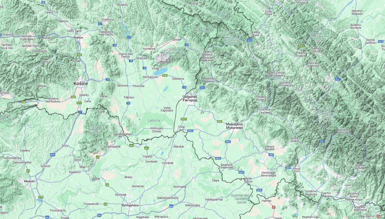
Not exactly, consider geographic depth. The Slovakian Mountains occupy a far larger and "deeper" area than Transcarpathia.

Outside of a few hills that raise a few hundred metres over the landscape, but have perfectly fine passages between them, there is a continuous plain from Košice to Vinohradiv:

1728689570453.png


The Union of Florence had a significant impact, the scale of later immigration and settling efforts also, while the effects of the Turkish wars and Tartar raids on Hungary's demographics can't be understated either.
The Union of Florence lasted about 15-20 years, and was over by the time of Mohacs.
Where did I write anything like that? I agreed that the Northern slopes of the Carpathians are generally more suitable for grazing in the Summer months. However, pastorialist population that keeps wandering back and forth between the two sides of the border cannot be claimed to be the population of a location.

Yeah, but they have to belong to a place. Why is it more fair that they are counted in the south rather than the north, if they would live in both areas?


Because that is concrete, quantifiable evidence.

Not of Orthodox populations, as Romhányi has elaborated in your own comment.

Again, your concrete quantifiable evidence leaves us with the idea that not even 7000 people would live in Constantinople in this era.


To attact settlers to areas that otherwise wouldn't be populated (in the foreseeable future).

Why not just get more Germans in that case? It's not like the Germans weren't available.


Because they likely came from there in the first place?
And then later on that actually happened?

As previously mentioned, why then go through the extra work of bringing them to Maramureș and then sending them back where they came from?


I mean, if you can provide any source that could serve as evidence to this, I would gladly receive it.

How come no literary evidence is needed for you to place Dragoș as a local noble from Moldavia, that's then brought over the mountains to become a Hungarian noble for a decade or two, and then sent back to Moldavia?

But to entertain a notion that the Vlachs might have lived as pastoralists in Maramureș, and then these existing chieftains were settling these pastoralist populations, we need literary sources?
 
  • 2
Reactions:
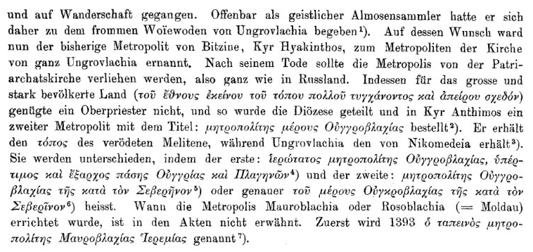
I feel like this pertains to the current discussion, though it is entirely in German and I don't feel like translating (original):
Untitled.png

Untitled2.png

Note that the book that this is from was written over 100 years ago.
 
Maybe Berat can be split into another province in its far east? or maybe Avlonas could be split too? I think Gijorakaster should possibly be represented too. however this is pretty good density i would say
I made a very amatuer rough map of giving Albania another 2 locations by splitting Berat and Avlona What do you think @ArVass ? Not sure what they should be named though

1728735315690.png


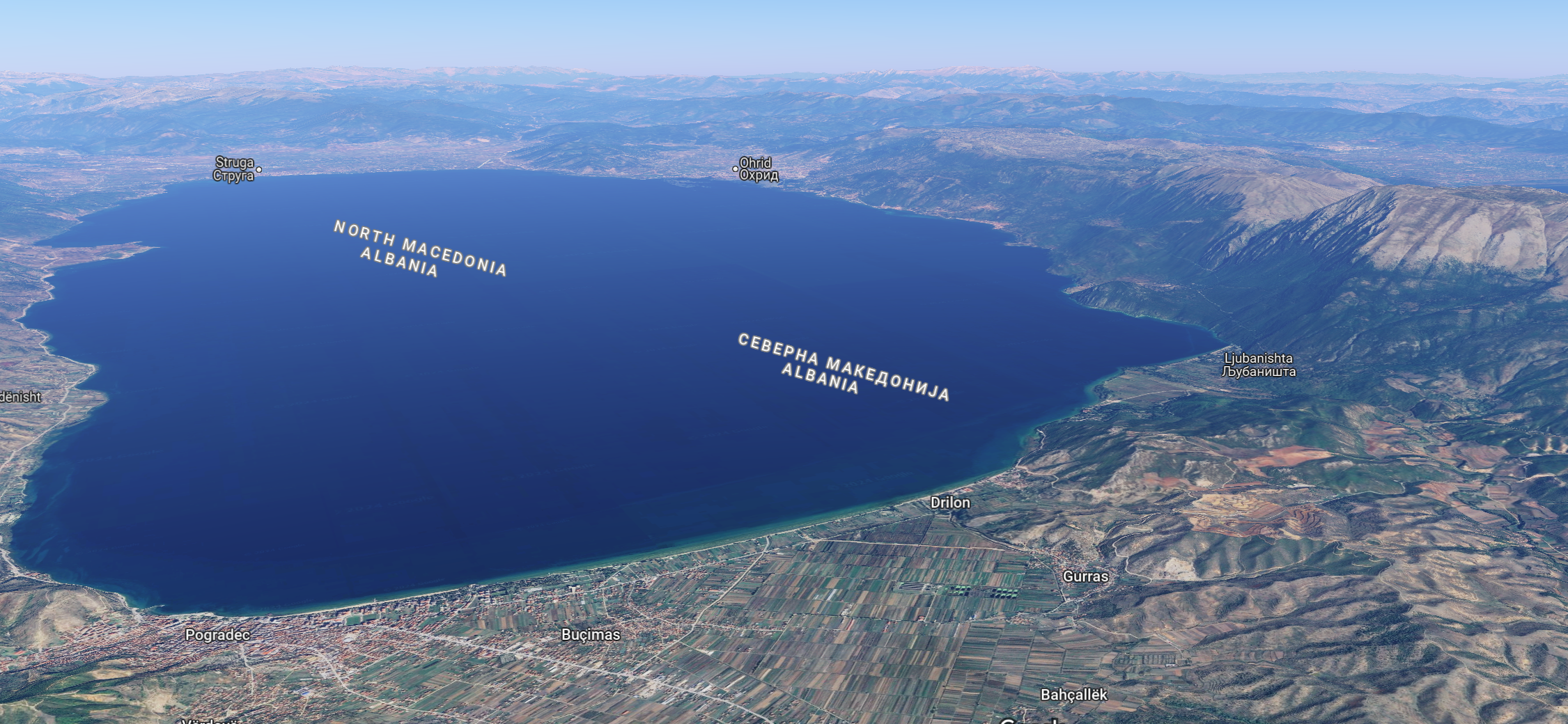
Also another question theres a massive mountain in between the strip of land between Lake Ohrid and Prespa? does that suffice enough to make it a wasteland? Although im not actually sure if there's historical or physical accuracy to that just a question What do you think? @ArVass
1728722216627.png
 
Last edited:
  • 1Like
Reactions:
@ZigTheNorweigan It's kind of imperative to know how to call split locations, though :p

Peshkopi in the north would be a very good addition, too. It could be split from parts of Debar and Dukagjini (which doesn't make sense as a location-name).

Keep in mind that 'urbanization' in Albania started in earnest during Ottoman times, so that's why a lot of towns in 1337 were either very small or not even in existence yet.
 
Last edited:
  • 1Like
Reactions:
Hello everyone,
Seeing the incredible work of other members in this forum, creating very detailed maps and summarising each country's position, I decided to do the same and put together a map for Bulgaria. I was mostly inspired by @Monix and his great posts regarding the subject, but I've also been taking note of all other efforts in this thread (@Antimonum , @buffon1313 , @vikinglord , @Nikicaga ). For my sources, well since this is mostly a visualisation of previous posts, I'll link to them and they'll have the associated research. For the locations I've added on my own, I'll of course give sources directly.
Now, before viewing the map let me explain how to interpret the colours:

Borders:
Blue - the borders of the location have not been altered with respect to the original
Yellow - the borders of the location have been altered, either to fit a newly added province or to better restructure surrounding locations
Green - borders of a newly added location

Names:
Orange - correction of the location's name, mostly to remove anachronisms
Yellow - the name has not been changed, serves to clear up which location is which
Green - the name of a newly added province

I. The Map and some notes

View attachment 1192241

I'd like to mention that this is the historically conservative version of the map, where each location has evidence for existing in the period under its respective name. I've also left out some smaller fortresses which I'll later include as additional locations if the devs want to increase the density further.
Now I'd like to note some things, which I find to be important or useful:

- The location of Razgrad has been removed and partitioned, due to the accounts for its existence being shaky. However I understand its benefits in regards to density so later on I'll propose an alternate scenario.

- Višesav should be Vishesav when in Bulgaria's domain, something more, I believe it should be in Bulgaria's hands to begin with as without this location a historical conflict in the very near future of the game between Bulgaria and Hungary would not be possible as they wouldn't share a border. And to that effect, the location should be altered to include some of the impassable terrain (Myhald on the Hungarian side respectively too) so that a connection exists between the two countries. - see the Hungarian occupation of Vidin on Wikipedia
Honestly I think there should be some more border changes in the political map, but this isn't the focus of this post.

- Pernik should exist as a separate location because it was still significant in the period and was part of Bulgaria as opposed to Serbia.

- Zibestova is an alleged old name of Svishtov, which existed in the time period and had some significance

- There should be more mountainous terrain and impassable regions around Stara Planina.

- Konstantsiya and Konstantsa, is not a mistake. The former is the name of a fortress that was present in the time period and corresponds to today's Simeonovgrad, the latter corresponds to the modern city of Consanța

- Dabilin should become Diampolis when in Byzantine hands. Perperek would be Perperikon.

- Preslav should actually have a slightly different southern border in my opinion, but I haven't reflected it because I can't precisely align a terrain map on top. It should follow the contour of Stara Planina, so the locations of Sliven, Lardeya and Aytos should expand a little more northward, like this:
View attachment 1192255 View attachment 1192257

- If Paradox chooses not to remove Razgrad (which should then at least be renamed to Hrazgrad) and instead favours to break up the region more to add additional strategic depth, then I propose locations be split in the following way:
View attachment 1192263

II. Additional locations
These are some bonus locations for increased density, since I can't be sure just how much Paradox would like to break up the region. All of them are historically attested and I'll even provide images of how I think the first few could look on the map, the rest I'll just write about.

- Petlyuka - a fairly notable fortress which could be used to split the Sredets (Sofia) and Pirot locations. Honestly I should've included this in the original map I personally think it's a great addition.
View attachment 1192294

- Rila - the monastery was granted villages by a royal charter of Tsar Ivan Shishman in 1371 and was economically significant. Currently it is entirely impassable terrain, but the location can be carved out the following way. Another issue however is that currently the borders between Serbia and Bulgaria would make it disconnected from Bulgaria, so either changes have to be made in the political map or the location redrawn from the north (less realistic)
View attachment 1192295

- Glozhen - a very obscure village today (Glozhene) but it did exist in the time period, and the monastery there (Glozhene monastery) was built all the way back in 1224, interesting history. Could be used to break up Bozhenitsa and Lovech and be a great mountain location to make the passage more difficult to conquer as it historically was.

- Madara - a fortress in the northeast of Bulgaria that was conquered by the Ottomans in 1388. It's notable, however it clusters closely to Shumen and Preslav, so I decided not to give it its own location. Depending on the level of granularity however it could prove to be useful.

III. Sources and links to posts
EDIT: Well I can't post links so instead I encourage you to check out the following things on your own:
@Monix
PROVINCES AND LOCATIONS (Part 1)
PROVINCES AND LOCATIONS (Part 2)
PROVINCES AND LOCATIONS (Part 3)
Post about Pernik's location

@Antimonum :
Rila Location and the Rila charter
Province structure and names

Sources for my own additions:
Hungarian occupation of Vidin Wikipedia page
Zibestova (Svistov's Wikipedia page in Bulgarian) - only in Bulgarian
Konstantsiya (Simeonovgrad's Wikipedia page in Bulgarian) - only in Bulgarian
Petlyuka (in Bulgarian) - sources outside of Wikipedia
Glozhene Monastery Wikipedia page
Madara (Wikipedia page in Bulgarian) - only in Bulgarian
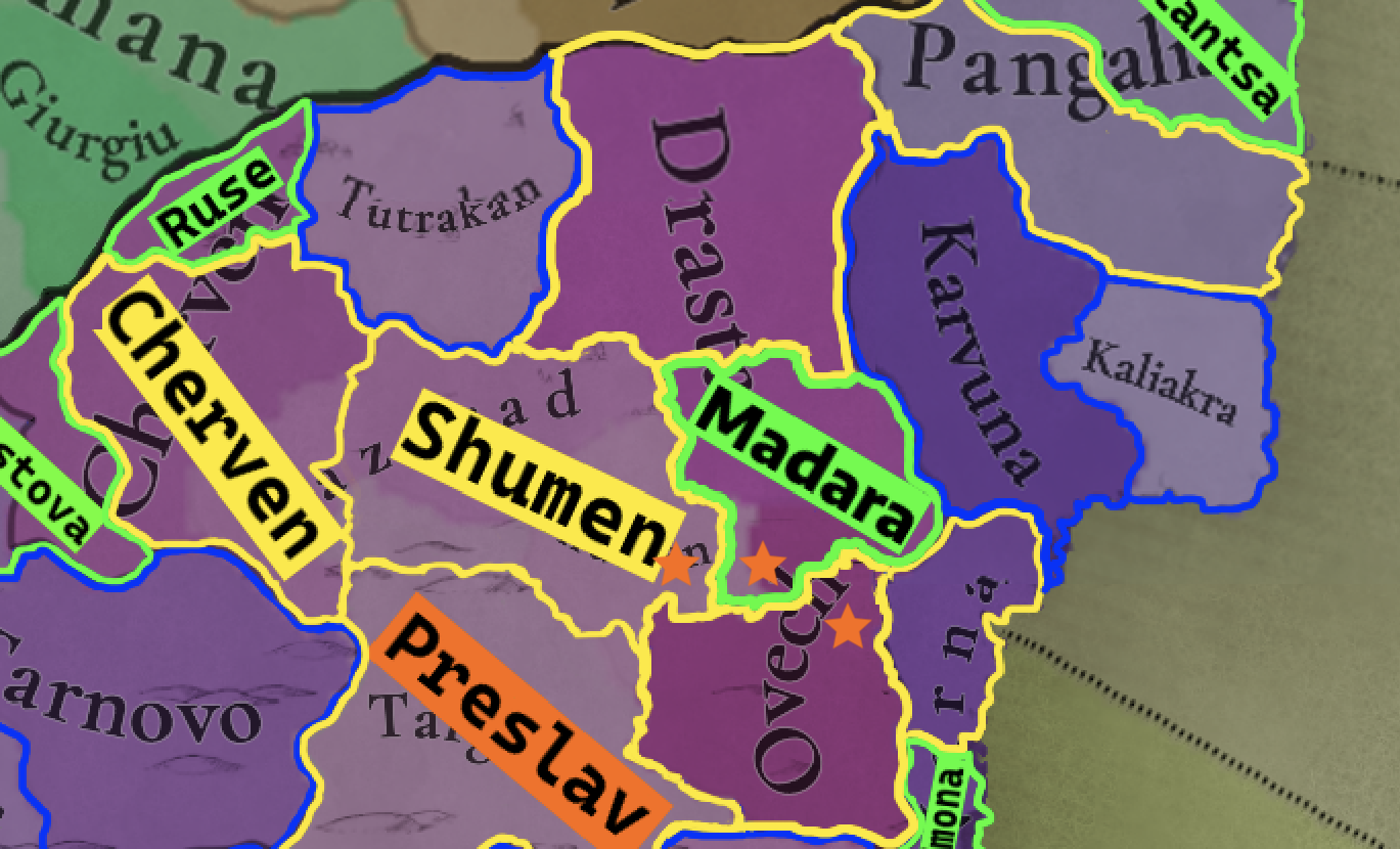
I decided to settle the Razgrad issue and find a more suitable substitute. In the main post I mentioned the fort of Madara which we know existed in the period and had relative importance. Although it is rather close to some of the other locations' main towns/forts, there is still enough wiggle room to fit it in a location of its own that makes sense. Here's my proposal on a map, note - the stars indicate the actual towns/forts of Madara, Shumen and Ovech respectively:
Madara.png
 
  • 4Like
  • 2
Reactions:
Some minor things:
Make Caracal location pointy, let the location borders follow the Olt all the way to the Danube.
A new location in the Danube Delta North of the St. George branch would be nice.

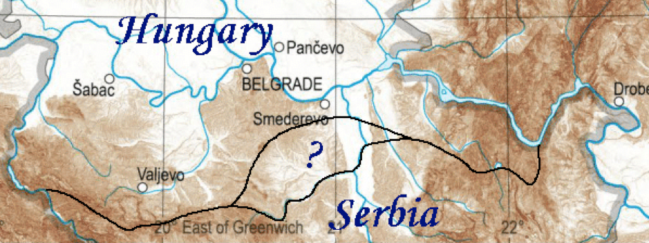
Also, referring back to a previous post of mine: Based on the what I could gather, this is what I believe the Hungarian-Serbian border could potentially have looked like in 1337:
1728847652560.png

Or something more or less along these lines. It must be noted however, that in 1339, Hungary lost everything East of the Drina and South of the Sava-Danube line, with the notable exceptions of Belgrade(probably) and Galambóc(Golubac)(certainly).
 
  • 3Like
  • 2
  • 1
Reactions:
Some minor things:
Make Caracal location pointy, let the location borders follow the Olt all the way to the Danube.
A new location in the Danube Delta North of the St. George branch would be nice.

Also, referring back to a previous post of mine: Based on the what I could gather, this is what I believe the Hungarian-Serbian border could potentially have looked like in 1337:
View attachment 1201808
Or something more or less along these lines. It must be noted however, that in 1339, Hungary lost everything East of the Drina and South of the Sava-Danube line, with the notable exceptions of Belgrade(probably) and Galambóc(Golubac)(certainly).
Branichevo and Kuchevo was part Serbia in 1337.

1728851841751.png
 
Last edited:
  • 3
  • 1Like
Reactions: