• We have updated our Community Code of Conduct. Please read through the new rules for the forum that are an integral part of Paradox Interactive’s User Agreement.

Tinto Maps #9 - 5th of July 2024 - Carpathia and the Balkans

Greetings, and welcome to another Tinto Maps! This week we will be taking a look at Carpathia and the Balkans! It will most likely be an interesting region to take a look at, with a lot of passion involved… So I’ll just make an initial friendly reminder to keep a civil discussion, as in the latest Tinto Maps, as that’s the easiest way for us to read and gather your feedback, and improve the region in a future iteration. And now, let’s start with the maps!

Countries:
Countries.png

Carpathia and the Balkans start in a very interesting situation. The Kingdom of Hungary probably stands as the most powerful country in 1337, but that only happened after the recovery of the royal power enforced by Charles I Robert of the House of Anjou, who reined in the powerful Hungarian nobility. To the south, the power that is on the rise is the Kingdom of Serbia, ruled by Stefan Uroš IV Dušan, who has set his eyes on his neighbors to expand his power. The Byzantine Empire, meanwhile, is in a difficult position, as internal struggles ended in Andronikos III being crowned sole emperor, at the cost of dividing the realm; both Serbia and Bulgaria have in the past pressed over the bordering lands, while the Ottomans have very recently conquered Nicomedia. The control over the Southern Balkans is also very fractioned, with a branch of the Anjou ruling over Albania, the Despotate of Epirus under the nominal rule of Byzantium as a vassal, Athens, Neopatria and Salona as vassals of the Aragonese Kings of Sicily, Anjou protectorates over Achaia and Naxos, and only nominal Byzantine control over Southern Morea. It’s also noticeable the presence of the Republics of Venice and Genoa, which control several outposts over the Adriatic and Aegean Seas. A final note: in previous maps, Moldavia was shown in the map, but we’ve removed it from it, and it will most likely spawn through a chain of events in the 1340s.

Dynasties:
Dynasties.png

The House of Anjou rules over Naples, Hungary, Albania, Achaia, and Cephalonia; they’re truly invested in their push for supremacy over the region. Apart from that, each country is ruled by different dynasties, except for Athens and Neopatria, ruled by the House of Aragón-Barcelona.

Locations:
Locations 1.png

Locations 2.png

Locations 3.png

Locations 4.png
This week we’re posting the general map of the region, along with some more detailed maps, that can be seen if you click on the spoiler button. A starting comment is that the location density of Hungary is noticeably not very high; the reason is that it was one of the first European maps that we made, and we based it upon the historical counties. Therefore, I’m already saying in advance that this will be an area that we want to give more density when we do the review of the region; any help regarding that is welcome. Apart from that, you may notice on the more detailed maps that Crete appears in one, while not being present in the previous one; because of the zooming, the island will appear next week along with Cyprus, but I wanted to make an early sneak peek of the locations, given that is possible with this closer zoom level. Apart from that, I’m also saying in advance that we will make an important review of the Aegean Islands, so do not take them as a reference for anything, please.

Provinces:
Provinces.png

Provinces! Nothing outstanding to be commented on here; as usual, we’re open to any feedback regarding them.

Terrain:
Climate.png

Topography.png

Vegetation.png

Terrain! The climate of the region is mostly divided between Continental and Mediterranean, with some warmer and some colder regions. Regarding the topography, the Carpathian mountains are famously important and strategic, while the Balkans are a quite hilly and mountainous region, which is also greatly covered by woods and forests.

Cultures:
Cultures.png

Here comes the fun part of the DD: The cultural division of the Balkans! A few comments:
  1. Hungary is full of different minorities. Transylvania, especially, is an interesting place: there we have a mix of ‘Hungarians’, ‘Transylvanians’ (which are the Romanian-speaking inhabitants of the region), ‘Transylvanian Germans’, and ‘Szekely’ people.
  2. We have divided the Southern Slavic-speaking region into their dialectal families of Slovene, Croatian, Bosnian, and Serbian.
  3. The Southern Balkans are mostly divided among Bulgarian, Albanian, and Greek cultures.
  4. We’re also portraying plenty of other cultures, such as Dalmatians, Aromanians, Sclavenes, Arvanites, Cumans, Jasz, or Ashkenazi and Romanyoti Jews.

Religions:
Religion.png

This one is also interesting. Apart from the divide between Western Catholicism and Eastern Orthodoxy, we have the Krstjani in Bosnia, Bogomils (the pink stripes both in Bosnia and Macedonia), and Paulicians in Thrace. The Jewish populations do not pass the threshold percentage to appear on the map, but there are plenty of communities across the region.

Raw Materials:
Raw Materials.png

The materials of the region. Something very noticeable is the richness of minerals, with plenty of Iron, Copper, Tin, Lead, Gold, and Silver. Specifically, Slovakia is very rich, and you definitely want more settlers to migrate to the region, and exploit its resources. The region is also very rich in agricultural resources, as you can see.

Markets:
Markets.png

The region is mostly divided among four markets: Venice, Pest, Ragusa and Constantinople.

Country and Location population:
Population 1.png

Population 2.png

Population 3.png

Population 4.png
Country and location population (which I’ve also sub-divided, and is under the Spoiler button).

And that’s all of today! I hope that you find the region interesting; we certainly think that it is. Next week we will go further south, and we will take a look at the Syrian Levant and Egypt. Cheers!
 
  • 193Like
  • 69Love
  • 7
  • 4
  • 3
  • 1Haha
Reactions:
I have some suggestions for improving the density and accuracy of the map, particularly in Hungary:

  • Add Tokaj Location: Please create a new Tokaj location out of south Zemplén and assign wine as its raw resource. Although the town is small, Tokaj wine's economic impact is significant.
  • Add Villány Location: Establish Villány as an independent location out of south Pécs, again with wine as a resource.
  • Wine Resources: Change Eger, Buda, and Veszprém's raw materials to wine to better reflect historical production. I am a bit too much into wine.
  • Add Žilina Location: Divide Trencin into East and West and name the eastern half Žilina.
  • Add Trnava/Nagyszombat Location: Create Trnava (Nagyszombat) out of the eastern part of Pressburg and some slices of surrounding locations.
  • Borsod Renaming: Rename Borsod to Diósgyőr or Miskolc if we are naming locations after towns.
  • Hlohovec Adjustment: Remove horses as a raw resource from Hlohovec. Hungary should have horses on the plains.
  • Rename Leibitz to Kežmarok: Kežmarok was a more important city historically.
  • Rename Beregovo to Berehovo/Beregszász: Split it into Southern Berehovo and Northern Mukacsevo/Munkács.
  • Change Yasine to Maramureș (Máramarossziget): This area was historically significant as a center for logging and salt mining.
  • Split Northwestern Nagyakálló: Create Szabolcs and assign fruit as a raw resource.
  • Split Bihar: Create an eastern Nagyvárad (one of the most important cities in Hungary) and Berettyóújfalu.
  • Rename Várda to Kisvárda.
  • Split Csanád: Create a southern Szeged with salt as a raw resource (it was a center of salt trade) and a northern Hódvásárhely (today's Hódmezővásárhely) with livestock.
  • Split Eastern Vasvár: Create Szombathely (one of the oldest towns in Hungary, also known as Savaria from the Romans).
  • Split the very eastern part of Baranya: Create Mohács with livestock.
  • Create a new location called Banská Štiavnica/Selmecbány: Located at the border of Óbars, Hont, and Banská Bystrica. This was one of the first royal free towns and a significant source of silver and gold.
  • Split Northern Prešov: Create Bardejov/Bártfa, an important commercial city on the trade route from Hungary to Poland.
  • Split Western Levoča: Create Poprad/Poprád with copper and a German population.
  • Split Northern Sopron: Create Kismarton/Eisenstadt.
  • Split Jakeb-Szállás: Create a southern Kecskemét and a northern Cegléd.
  • Rename Bodrog to Baja.
  • Split Zalavár: Create a northern Egerszeg (Zalaegerszeg today) and southern Kanizsa.
  • Split Segesd and Somogyvár: Create Kaposvár.
  • Split Eastern Eger: Create Gyöngyös.


    These changes would enhance the historical accuracy and economic representation of Hungary.
This basically adds all Hungarian locations I would like to see! Great list. Slovakia could maybe use even a bit more love.

Also, I think there's something wrong with the placement of Radna/Beszterce; Pretty sure Radna should be north-east of Beszterce and I don't think the current position allows this.
 
  • 3Like
  • 1
Reactions:
First two points have been suggested, but I think it should be underlined:

1. Preßburg should be divided into two parts: Trnava (Nagyszombat) should be created: it was the first city in the territory of Slovakia to become a royal free city, later in the 17th century it was an important place of anti-reformation and humanism in Hungary (there was a Jesuit university).

2. Trenčín should be divided into two parts: Žilina (Zsolna) should be created: its history is quite well documented, it was a privileged city, a bit important also for Slovak history, as it was granted Privilegium pro Slavis.

3. This may be rejected by some Hungarians, but... I believe that the Slovak minority line (shaded territory) should be moved at least + 1 or 2 provinces down to Pannonia, as there were minorities of Slavs/Slovaks in medieval Pannonia. There is an opus magnum of Slovak slavist Ján Stanislav: Slovenský juh v stredoveku I. – II. (1948; ²1999, 2004; fr. Les régions Slovaques méridionales au moyen âge, lit. transl. Slovak South in Medieval Age) which on the base of etymology of toponyms shows, there were Slovaks near Balaton in 14rd-15th century. The first volume is expert text on the topic, the second volume is a thorough dictionary analysis of various geographical names (toponyms) from the territory of Hungary. Stanislav wrote (Vol. I., p. 11-12)
"Our research has shown that the settlements of the Slovaks in Pannonia went past Lake Neusiedl to the west, then the Slovene-Slovak border curved through the Rabice area (Hungarian Répce, German Rafnitz) to the southeast, and then along the left side of the Ráby River to the south. In the Zalán county it followed the Krka (Hungarian: Kerka) basin in the west, better said, perhaps, rather, the watershed of the Krka and Zala, in the south it follows approximately the watershed of the Drava and Zala. In the Šomod county, the border between the Slovaks and the southern Slavs follows the watershed of the Drava and Lake Balaton, at the watershed of the right tributaries of the Kapoš and the eastern tributaries of the Drava. In the Baranya and Tolna county this direction is also maintained. On the Danube the Slovaks met the southern Slavs between Bogyiszló (*Buďislav), which still has a Slovak spelling, and Szeremle (*Srěmľani), which already has a South Slavic feature. This is, of course, just an ideal line between Slovaks and southern Slovenes. We follow it according to the spelling features of the various local names. We can see that this boundary has its justification also in geographical terms. We observe that the Slovak population kept to the tributaries of the Danube and Lake Balaton, but did not descend any further into the Drava area, which naturally belongs to the sphere of interest of the southern Slavs. This line may have deviated or diverged somewhat in places. It would be difficult to ascertain today. However, its general direction is more or less certain. Inside this territory we find several typically Slovak features. In some places Slovaks still live today. We have not ascertained whether they are a continuation of the old Slovaks, and whether they are perhaps a new colony. The continuation of the old Slovaks would certainly be the Slovak villages along the Danube around Esztergom, etc. In a word, the largest part of Pannonia was inhabited by Slovaks [...]
The development of the name Zobor shows us that the Hungarians in the 10th cent. did not stay in Nitra. The charter of the Zobor abbey from 1111 does not record 'not a single church dignitary with a Hungarian name. Apart from Christian and some German names, these dignitaries have Slovak names. These names, together with the development of the name Zobor, show that the Slovaks held their position in the cultural and ecclesiastical history of Nitra even after the great epoch of the 9th century. Only 25.7% of Hungarian settlements were found in the vicinity of Nitra in the XIIth century. The compact Slovak settlement reached as far as the Danube and from there it went, admittedly, further south. Along the Danube, from Vacov or so, a belt of Slovak villages stretches even today. In the past there were more of them. Below Pest, much to the south, around Kaloča, etc., there were also Slovaks, but there were not many of them. It seems to have been an infiltration from across the Danube, from Pannonia; Matra and Bakonyerdő were also quite densely populated by Slovaks before the arrival of the Hungarians. Their settlements extended as far as the Tisza. The Tokaj hills and the whole area between Tisza and Košice had a fairly regular Slovak settlement, i.e. as far as the terrain allowed it. Further to the east, the Slovaks reached far to the east along the Tisza. They also lived in today's Carpathian Ukraine, even from Uzhhorod eastwards, but mostly occupied important communication and strategic points. The guards on these borders of "old Slovakia" were the Central Slovak dialect. Russians were also encountered in eastern Slovakia before the arrival of the Hungarians. They settled on their present territory and also among the Slovaks. Some of the regions, today Rusyn, are originally Slovak. This is just an interesting finding.
(p. 16)

In the dictionary volume he shows how names from the old Slovak dialect were used in medieval manuscripts from Pannonia also in the 14th-15th century. There is also a map appendix to the books, which is difficult to reproduce here due to its size, division and the density of toponyms on it.
 
Last edited:
  • 7Like
  • 3
  • 2
  • 1
Reactions:
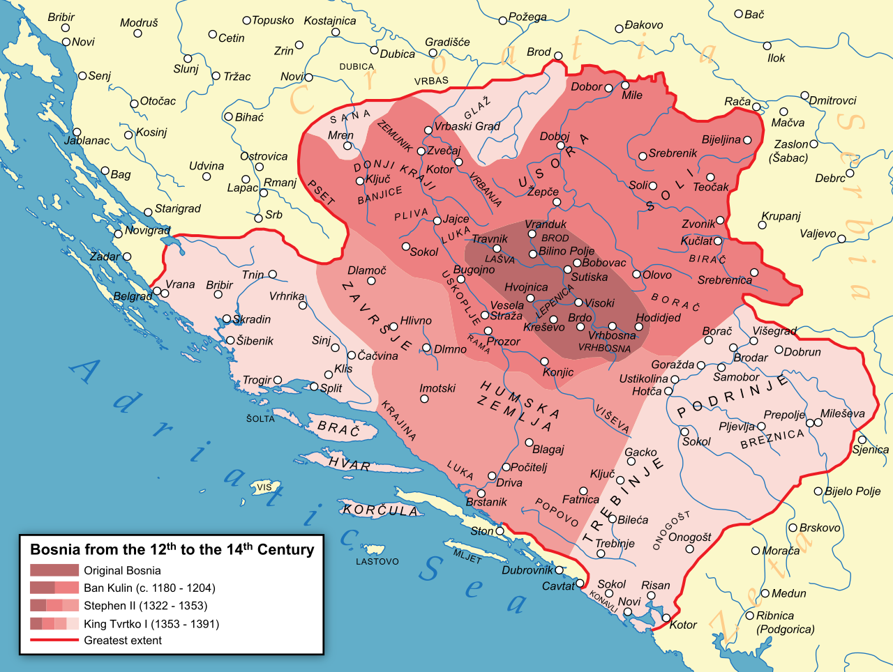
It's abosuletly non sensical to believe that Bosnia menaged to convert entire new region to Bogumilism in span of 11 years let alone for it to spread to Trebinje or Western Serbia. As stated John A. Fines work, Hum was a Orthodox province.
I didn't said anything about converting the whole province, we spoke about mebmers of Bosnian church, aka Krstjani, being present in those provinces, and they surelly were.
East part of Hum, known as Zahumlje, was majority Orthodox, that's true.
 
  • 1Like
Reactions:
It is such a delight to see my little hometown represented on the map. I suppose it's too early to provide feedback on Austria? Some towns need to get back to the right side of the Danube where they belong. I'm getting my notes ready for the Tinto Maps on the HRE!

In anticipation of that, I can make some suggestions for the Austro-Hungarian borderlands (modern Burgenland). If you want to increase the location density in this region, there are plenty of notable locations that can be added. Following the border south from modern Bratislava, I believe the locations along the border should be: Köpcsény (Kittsee in German), Kismarton (Eisenstadt), Sopron (Ödenburg), Kőszeg (Güns), and Németújvár (Güssing). If that's too much, Köpcsény is negligible, but I consider Kismarton and Németújvár (the seat of the Batthyány magnates) almost necessary additions.

All of these locations make sense as hills, except Köpcsény, which should be Flatland or perhaps Marshland. The entire area was quite heavily fortified as part of the Gyepű line, so placing castles or other medieval fortification-style buildings in these locations would be very appropriate. I'm not as firm on the area's settlement history as I'd like to be, but all of these locations would have a large Bavarian population and in some places perhaps even a Bavarian majority. I would guess maybe Köpcsény or Kismartin, but that's 100% speculation. Historically, those two became a home to major Jewish communities - the Siebengemeinden - in the 17th century, but I'm not sure how that could be represented in the game.

And some miscellaneous notes on the region:
- Szombathely (Steinamanger) is a shoo-in for a missing location and its absence is quite surprising. Following my other suggestions, it would be south of Kőszeg and east of Németújvár.
- The localisation for Bratislava seems to be inconsistent right now. As a location it is named in German (Preßburg) and as a province in Hungarian (Pozsony).
- I believe the Neusiedler See/Fertő would be large enough to represent on the map. Especially because it presents an interesting obstacle that makes the Western Hungarian border even more defensible.
- For most of the timeline of the game, the Neusiedler See was unregulated and extended into a much larger marsh region to the east and southeast, the Hanság. I don't have a specific location to suggest for this area, but the area should have at least a single Marsh location. Perhaps Kapuvár? Ideally someone who knows Hungary better than I do could weigh in.
 
Last edited:
  • 5Like
  • 1Love
Reactions:
FEEDBACK ON LOCATION NAMES

Please note: this post will not address any redrawing of the borders (of which there will be many necessary), I will do that later. This post exclusively concerns the names of locations as they are presented in the OP.

Before everything, I'll start with the current Romanian alphabet. It's made up of the standard 26 Latin letters + the letters Ă (A-breve), Â (A-circumflex), Î (I-circumflex), Ș (S-comma) and Ț (T-comma). My naming suggestions will be based on transliterations of names from the Romanian Cyrillic alphabet to the current one (see this table of correspondence). That also means that all instances of Ǎ (A with caron) and Ş (S-cedilla) present on the map are incorrect.

Some sources I've used for the identification of Cyrillic names include: geography manuals from 1835, 1838, 1840, 1841, 1847), various texts written in Romanian with Cyrillic letters, found on this website, and an index of all Wallachian towns and villages written in 1850.

WALLACHIA:
Lichirești
- all good
Oraşul de Floci - rename to just Floci
Brǎila - rename to Brăila (a-breve instead of a-caron)
Râmnicu Sǎrat - well, this one was called Râmnic for most of its existence (including the early 19th century), but I understand the need to differentiate the two towns named the same; as such, it should be renamed to Slam Râmnic, which is the name it had before being changed to Râmnicu Sărat (it also happens to be the name of the județ - jurisdiction, district, commonly but improperly translated to county - it was part of)
Buzǎu - rename to Buzău (a-breve instead of a-caron); this one was a bit complicated, because I've seen the form Buzeu as well, and sometimes the two spellings were even present on the same page; I have decided to be conservative about it however, as I have not managed to find a text from early enough to confirm either spelling
Sǎcuieni - that's the name of the județ, but not the name of any town or village in it; two options to replace it with: Văleni (attested in 1431, but quite up north and not on the road connecting the locations west and east of it), and Bucovu (modern spelling Bucov; attested later than Văleni, in 1473, however it links the neighbouring locations); of the two, I prefer the latter
Ploești - thank you for taking my earlier feedback about it, but now I'd like to revise my thoughts: the settlement was first mentioned in documents in 1503, and it only started gaining relevance in 1597, becoming the main settlement in its location sometimes during the 17th century; I recommend replacing it with Târșoru (modern spelling Târgșor); this was the important trade post before the rise of Ploești
Târgoviște - I would recommend renaming it to Târgoviștea (Тѫрговіщѣ)
Bucureşti - this one is very tricky, because the first mention of it in documents was in 1459, during Vlad the Impaler, when he only started building fortifications there; given that the city will later go on to become the capital of Wallachia, it's jarring to see it present on the 1337 map; as such, my strong recommendation is to replace it with Sneagovu (modern spelling: Snagov), after the monastery attested during Mircea's reign, and have the location change its name to București through event; either way, that s-cedilla needs to be replaced with s-comma
Comana - all good
Giurgiu - all good
Zimnicea - all good
Ruşii de Vede - rename to Rușii de Vede (with s-comma)
Câmpulung Muscel - rename to Câmpulungu (I know about the need to differentiate it from the other one; I'll bring a solution when I talk about it)
Argeş - rename to Argeș (s-comma)
Slatina - all good
Turnu Mǎgurele - rename to just Turnu; Turnu Măgurele is what it started getting called after the original settlement was moved to the nearby Măgurele in the 19th century
Râmnicu Vâlcea - rename to Râmnic, as it was known for most of its existence; doing this is safe as the other one will be Slam Râmnic
Caracal - all good
Craiova - all good
Calafat - rename to Calafatu
Strehaia
- all good
Severin - all good
Strimba - rename to Strâmba
Târgu Jiu
- this one is a pain in the neck, because I've seen it spelled Târgujiu, Târgujiului, Târgu-Jiului, Târgu-Jiiului (Тѫргꙋ-Жіюлꙋĭ); Cantacuzino's chronicle seems to call it Jiiului as well, so let's go with Târgu Jiiului
Târgu Bengǎi
- wow this one is incredibly tricky, undergoing a lot of name changes; I guess keeping it as Târgu Bengăi (with A-breve) could be fine, but I'm leaning towards Târgu Gilort, which was an earlier name (1484)

Moldova in another post, I'm taking a break for now.
@Pavía Thanks for the screenshot, but could you please also post one of the areas (as in the things made up of provinces in the game)?
Great list! I think some slightly anachronistic locations are fine, as replacements are sometimes hard to find/very obscure. That's why I'd be fine with Bucuresti and Ploesti and the likes (the devs could juggle with the amount of population/development before their historical growth and all that), but otherwise great feedback.
 
Could you change the colors of Bulgarian, Greek, and Turkish? They are currently way too similar. Maybe make Greek a light blue or purple, Bulgarian gray, and Turkish a red or green?
 
  • 5Like
Reactions:
As already said, spread of stećci are proof for that. Map of stećci almost 100% coincide with Bosnian medieval state, spreading to the surrounding area too.
So, to claim there were no Krstjani ever in western Serbia or Hum, you should have bulletproof evidence.
Insult me as much as you want, you say that the spread of stećci almost 100% coincide with the borders of the Bosnian medieval state and based on that you say that Bogumils existed in western Serbia and Hum. According to you, thus, the logical conclusion is that stećci coincide with the spread of Bogumils.
 
  • 2
Reactions:
This is awesome so far, but I cant help but have some issues with the demographics:
1. There should be more Albanians in Old Herzegovina/Montenegro, documents as early as the 13th century mention the presence of Albanian tribes in these regions, such as the Mataguzi, Mataruge, Shpani, Bukumiri, Hoti, Bytadosi, Macurri to name a few.
2. Thesprotia and Himara was inhabited by Albanians as early as 1210, to quote the Venetian document "The land facing the Corfu is inhabited by Albanians". Not saying they were the majority, but some of the most prominent tribes in the region were the Zenebishi (later a principality), Malakasioi, Mazreku, Ljosha, etc.
3. Northern Albania, the region in the game being Komani, should be staunchly Catholic (a document to support the claim http://www.albanianhistory.net/1332_Making-the-Passage/index.html) due to Latin influence.
Other than that, you have done a fantastic job so far, keep it up!
 
Last edited:
  • 3
  • 2Like
  • 2
Reactions:
If you are able te get better names for the Baltic and Silesian Germans, we might have a deal.
Germanic Silesian is sometimes called "Lower Silesian" in contrast with the Slavic "Upper Silesian" but I think this is a result of those languages being confined to these regions in modern times.
As for Baltic Germans I'd have no idea of any separate terms for them, maybe "Saks" which is an old-timey Estonian term for Germans in general.

I do like the current "Baltic/Silesian/Transylvanian/Carpathian German" arrangement (I think they especially work better as umbrella terms since Transylvanian and Carpathian Germans have many subgroups like Soxen, Zipsers, Satu Maru), if you decide to do the right thing and have "Prussian German" as a culture so you can finally get rid of the awkward "West Baltic" culture then I say just keep it.
 
Last edited:
  • 2Like
Reactions:
To be honest, we aren't completely happy with the concept either, as we have four different cultures for the 'Germans of the East': Baltic German, Silesian German, Carpathian German, and Transylvanian German. But we think that it's the 'less bad' solution to portray the cultural melting pot that these places were for the different German settlers.

Wikipedia calls them Soxen (from their endonym Såksesch); couldn't you just use it, similar to how you use endonyms for Jewish minorities? The other three probably have some one-word terminology for themselves too.
 
  • 4Like
Reactions:
This is awesome so far, but I cant help but have some issues with the demographics:
1. There should be more Albanians in Old Herzegovina/Montenegro, documents as early as the 13th century mention the presence of Albanian tribes in these regions, such as the Mataguzi, Mataruge, Shpani, Bukumiri, Hoti, Bytadosi, Macurri to name a few.
2. Thesprotia and Himara was inhabited by Albanians as early as 1210, to quote the Venetian document "The land facing the Corfu is inhabited by Albanians". Not saying they were the majority, but some of the most prominent tribes in the region were the Zenebishi (later a principality), Malakasioi, Mazreku, Ljosha, etc.
3. Northern Albania, the region in the game being Komani, should be staunchly Catholic (a document to support the claim http://www.albanianhistory.net/1308_Anonymous-Description/index.html) due to Latin influence.
Other than that, you have done a fantastic job so far, keep it up!
Can you provide the Venetian document for Thesprotia ? I knew the bulk of the Albanians started to migrate to Thesprotia during the time period of the game.Peter Losha became lord at 1350.
 
  • 3Like
Reactions:
First two points have been suggested, but I think it should be underlined:

1. Preßburg should be divided into two parts: Trnava (Nagyszombat) should be created: it was the first city in the territory of Slovakia to become a royal free city, later in the 17th century it was an important place of anti-reformation and humanism in Hungary (there was a Jesuit university).

2. Trenčín should be divided into two parts: Žilina (Zsolna) should be created: its history is quite well documented, it was a privileged city, a bit important also for Slovak history, as it was granted Privilegium pro Slavis.

3. This may be rejected by some Hungarians, but... I believe that the Slovak minority line (shaded territory) should be moved + 1 or 2 provinces down to Pannonia, as there were minorities of Slavs/Slovaks in medieval Pannonia. There is an opus magnum of Slovak slavist Ján Stanislav: Slovenský juh v stredoveku I. – II. (1948; ²1999, 2004; fr. Les régions Slovaques méridionales au moyen âge, lit. transl. Slovak South in Medieval Age) which on the base of etymology of toponyms shows, there were Slovaks near Balaton in 14rd-15th century. The first volume is expert text on the topic, the second volume is a thorough dictionary analysis of various geographical names (toponyms) from the territory of Hungary. Stanislav wrote (Vol. I., p. 11-12)
"Our research has shown that the settlements of the Slovaks in Pannonia went past Lake Neusiedl to the west, then the Slovene-Slovak border curved through the Rabice area (Hungarian Répce, German Rafnitz) to the southeast, and then along the left side of the Ráby River to the south. In the Zalán county it followed the Krka (Hungarian: Kerka) basin in the west, better said, perhaps, rather, the watershed of the Krka and Zala, in the south it follows approximately the watershed of the Drava and Zala. In the Šomod county, the border between the Slovaks and the southern Slavs follows the watershed of the Drava and Lake Blatná, at the watershed of the right tributaries of the Kapoš and the eastern tributaries of the Drava. In the Baranya and Tolna county this direction is also maintained. On the Danube the Slovaks met the southern Slavs between Bogyiszló (*Buďislav), which still has a Slovak spelling, and Szeremle (*Srěmľani), which already has a South Slavic feature. This is, of course, just an ideal line between Slovaks and southern Slovenes. We follow it according to the spelling features of the various local names. We can see that this boundary has its justification also in geographical terms. We observe that the Slovak population kept to the tributaries of the Danube and Lake Balaton, but did not descend any further into the Drava area, which naturally belongs to the sphere of interest of the southern Slavs. This line may have deviated or diverged somewhat in places. It would be difficult to ascertain today. However, its general direction is more or less certain. Inside this territory we find several typically Slovak features. In some places Slovaks still live today. We have not ascertained whether they are a continuation of the old Slovaks, and whether they are perhaps a new colony. The continuation of the old Slovaks would certainly be the Slovak villages along the Danube around Esztergom, etc. In a word, the largest part of Pannonia was inhabited by Slovaks [...]
The development of the name Zobor shows us that the Hungarians in the 10th cent. did not stay in Nitra. The charter of the Zobor abbey from 1111 does not record 'not a single church dignitary with a Hungarian name. Apart from Christian and some German names, these dignitaries have Slovak names. These names, together with the development of the name Zobor, show that the Slovaks held their position in the cultural and ecclesiastical history of Nitra even after the great epoch of the 9th century. Only 25.7% of Hungarian settlements were found in the vicinity of Nitra in the XIIth century. The compact Slovak settlement reached as far as the Danube and from there it went, admittedly, further south. Along the Danube, from Vacov or so, a belt of Slovak villages stretches even today. In the past there were more of them. Below Pest, much to the south, around Kaloča, etc., there were also Slovaks, but there were not many of them. It seems to have been an infiltration from across the Danube, from Pannonia; Matra and Bakonyerdő were also quite densely populated by Slovaks before the arrival of the Hungarians. Their settlements extended as far as the Tisza. The Tokaj hills and the whole area between Tisza and Košice had a fairly regular Slovak settlement, i.e. as far as the terrain allowed it. Further to the east, the Slovaks reached far to the east along the Tisza. They also lived in today's Carpathian Ukraine, even from Uzhhorod eastwards, but mostly occupied important communication and strategic points. The guards on these borders of "old Slovakia" were the Central Slovak dialect. Russians were also encountered in eastern Slovakia before the arrival of the Hungarians. They settled on their present territory and also among the Slovaks. Some of the regions, today Rusyn, are originally Slovak. This is just an interesting finding.
(p. 16)

In the dictionary volume he shows how names from the old Slovak dialect were used in medieval manuscripts from Pannonia also in the 14th-15th century. There is also a map appendix to the books, which is difficult to reproduce here due to its size, division and the density of toponyms on it.
is there a map of what the author claims was the Slovak linguistic area?
 
  • 1Like
Reactions:
It would be cool if in Project Caesar, unlike EU4, the Balkan Slavic countries had some flavor, like their own events and some monuments (if this mechanic is in the game)

Obviously I'm not suggesting that they have the same amount of flavor as the prominent nations at the time, but having something would be nice.

It's an interesting period for Serbia, Croatia, Bosnia. For example, in Croatia and Dalmatia we have some interesting figures in the renaissance, Serbia could have special events about its collapse, and also the Alemannic Guard. In the context of the Ottoman invasions, there are many things that could be explored, such as the Hajduks, the Uskoks, the military border, the election in Cetin, the conversion of part of Bosnia, the Serb militias, etc. However, even though EU4 took place precisely during this period, this was practically not represented.

I only mentioned the southern Slavs because I don't know much about the other countries in the region, but for example, Albania is also in a very interesting period shortly after the game's start date.
I don't know, I think that in EU4 the region gives the impression that nothing happened there during that period, which was not the case.
 
  • 8Like
  • 2
Reactions:
Bosnia as a culture or ethnic group did not exist in 1337. It was only after religious conversion and turkification of the locals that they appear that too after 1460. I am being impartial because I am neither from the Balkans nor follow any form of christianity or islam. So having bosnian appear so many years ago is like having Russian identity in 1300
how can you be so wrong in 2 lines only
Bosnia was the name of the region , it appeared on texts since 10th century this mean 900s and was known as Bosona . it became known as kingdom of Bosnia in 1377.
as for Russia of course the identity exist . the Term Russia exist in medieval texts since 900s aswell and even the various principalities were known as Russias in plural and the tsar from any principality doesnt matter if kyiv/kiev or novgorod or Ryazan or smolensk etc would be known as " Tsar of all of Russias" in plural again.
if you go to the historic document of the rulers of Kievan Rus you will find the name Russia written and easy to read . Rus we use here in eastern europe wasnt just Rus but was literally Rusija .

sorry but i think you are only following a hateful agenda here trying to deny existence of some entities just because of modern day reasons as so many try to achieve like those who call Russia as moscovy out of spite

1720202819489.png
 
  • 5Like
  • 1
Reactions:
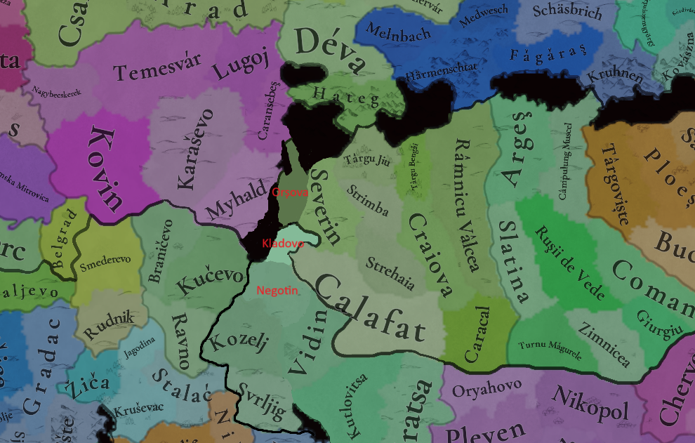
As a few people have pointed out so far, it doesn't make sense to not have Bulgaria border Hungary on the Danube near Orșova. Every map I've found seems to indicate this:

File:Second Bulgarian Empire under the rule of Ivan Alexander (1331-1371).png
File:Bulgaria-Theodore Svetoslav-es.svg

https://es.wikipedia.org/wiki/Teodoro_Svetoslav https://en.wikipedia.org/wiki/Second_Bulgarian_Empire

Map_of_the_Serbian_Empire%2C_University_of_Belgrade%2C_1922.jpg


The last time Serbia and Bulgaria were at war was in 1330, when Byzantium allied with Bulgaria to try and squash the rising Serbian power. In the battle of Velbazhd (modern-day Kyustendil), the Serbians scored a victory against the Bulgarian army, leading to the negotiation of a peace treaty in which Bulgaria did not lose any territory. One should therefore consider Bulgaria's 1337 border with Serbia to be the same as that of 7 years prior (above). After this, the two nations would remain on good terms until the Ottoman conquests, with there even being a marriage pact sealed between them.
https://en.wikipedia.org/wiki/Bulgarian–Serbian_wars_(medieval)

The locations of Višesav, Kozelj and Svrljg should belong to the Despot of Vidin (along with the remainder of the Vidin province) at the start of the game, which would either be a vassal of Bulgaria, or its own independent polity. There are sources which describe Svrljg as being Bulgarian as far back as 1278:
The Late Medieval Balkans A Critical Survey From The Late Twelfth Century To The Ottoman Conquest by John v. A. Fine Jr. (pgs 183-184).

In 1291, the deposed king of Serbia, Dragutin, allied with Hungary to wage war on the boyar princes, Darman and Kudelin, who controlled the principalities of Braničevo and Kučevo. After their annexation, Shishman of Vidin declared a retaliatory war against Dragutin, but was ultimately pushed back and his seat of power, the city of Vidin, was sacked, whilst he himself fled across the Danube into friendly Tartar lands. Ultimately, Dragutin and his Hungarian allies chose to reinstate Shishman rather than annex his lands, causing the Despotate of Vidin to become a Serbian client state until Shishman's death in ~1308 when his son was elected to the Bulgarian throne. This was the only war (besides Darman and Kudelin's failed incursion in 1284) between Serbia and Bulgaria from the year 1278 to 1330, which suggests, given the earlier sources regarding Bulgarian possession of Svrljg, that the territory never changed hands in that time. And nor was it exchanged after the battle of Velbazhd, as was already established. Thus Svrljg should be a Bulgarian territory in 1337, alongside the far minor territory of Kozelj, which can also be assumed to belong to the Despotate of Vidin. As for Višesav, it is stated that Shishman's domains extended as far west as the Iron Gates gorge.

Now, as for the locations themselves, I would argue that Višesav is an incredibly obscure name to use for the location. The only source I could find that cites this name is:
URBANIZATION AND TRADE AT THE TURBULENT BORDER: SERBIAN TOWNS ON THE DANUBE 1402-1459, Aleksandar KRSTIĆ, The Institute of History Belgrade (pg 368)
and even then, the paper highlights that the exact location of this fortified town is uncertain, not to mention its ultimate fate. The first time the name appears is in the 1400s, and it only seems to have lasted a couple of decades before being conquered and forgotten. I would argue that Negotin is a far better candidate, as it is at least a city that exists in the modern day with some historical significance (an alternative choice would be Rogljevo, which once was a Roman settlement called Selište).

The other thing missing from the map is the city of Orșova, which is also a location of historical significance (was once a Roman port city), and which controls the passage into Hungary. I would also argue that, by the same logic, Negotin should be split in two to allow for Kladovo to serve as the opposite side of Trajan's bridge at the Iron Gates (several different names can be chosen for Kladovo, see the source below).
https://en.wikipedia.org/wiki/Orșova

Here's what I propose:
Locations 2.png
 
  • 8Like
  • 2
  • 2
Reactions:
It would be cool if in Project Caesar, unlike EU4, the Balkan Slavic countries had some flavor, like their own events and some monuments (if this mechanic is in the game)

Obviously I'm not suggesting that they have the same amount of flavor as the prominent nations at the time, but having something would be nice.

It's an interesting period for Serbia, Croatia, Bosnia. For example, in Croatia and Dalmatia we have some interesting figures in the renaissance, Serbia could have special events about its collapse, and also the Alemannic Guard. In the context of the Ottoman invasions, there are many things that could be explored, such as the Hajduks, the Uskoks, the military border, the election in Cetin, the conversion of part of Bosnia, the Serb militias, etc. However, even though EU4 took place precisely during this period, this was practically not represented.

I only mentioned the southern Slavs because I don't know much about the other countries in the region, but for example, Albania is also in a very interesting period shortly after the game's start date.
I don't know, I think that in EU4 the region gives the impression that nothing happened there during that period, which was not the case.
The Hundred Years Croatian-Ottoman war for example needs to be a situation, it went on from 1493 to 1593 and had a major impact on the region and Europe in general. The establishment of the Military Frontier was one of the most important things that the Austrians did and it had a crazy impact on the 30 years war and on the Austrian war of succession.

The effects of this period are massive, I have already outlined the possible mechanics and the history behind it all when the situations diary came out.
 
  • 7
  • 1Like
Reactions: