• We have updated our Community Code of Conduct. Please read through the new rules for the forum that are an integral part of Paradox Interactive’s User Agreement.

Tinto Maps #9 - 5th of July 2024 - Carpathia and the Balkans

Greetings, and welcome to another Tinto Maps! This week we will be taking a look at Carpathia and the Balkans! It will most likely be an interesting region to take a look at, with a lot of passion involved… So I’ll just make an initial friendly reminder to keep a civil discussion, as in the latest Tinto Maps, as that’s the easiest way for us to read and gather your feedback, and improve the region in a future iteration. And now, let’s start with the maps!

Countries:
Countries.png

Carpathia and the Balkans start in a very interesting situation. The Kingdom of Hungary probably stands as the most powerful country in 1337, but that only happened after the recovery of the royal power enforced by Charles I Robert of the House of Anjou, who reined in the powerful Hungarian nobility. To the south, the power that is on the rise is the Kingdom of Serbia, ruled by Stefan Uroš IV Dušan, who has set his eyes on his neighbors to expand his power. The Byzantine Empire, meanwhile, is in a difficult position, as internal struggles ended in Andronikos III being crowned sole emperor, at the cost of dividing the realm; both Serbia and Bulgaria have in the past pressed over the bordering lands, while the Ottomans have very recently conquered Nicomedia. The control over the Southern Balkans is also very fractioned, with a branch of the Anjou ruling over Albania, the Despotate of Epirus under the nominal rule of Byzantium as a vassal, Athens, Neopatria and Salona as vassals of the Aragonese Kings of Sicily, Anjou protectorates over Achaia and Naxos, and only nominal Byzantine control over Southern Morea. It’s also noticeable the presence of the Republics of Venice and Genoa, which control several outposts over the Adriatic and Aegean Seas. A final note: in previous maps, Moldavia was shown in the map, but we’ve removed it from it, and it will most likely spawn through a chain of events in the 1340s.

Dynasties:
Dynasties.png

The House of Anjou rules over Naples, Hungary, Albania, Achaia, and Cephalonia; they’re truly invested in their push for supremacy over the region. Apart from that, each country is ruled by different dynasties, except for Athens and Neopatria, ruled by the House of Aragón-Barcelona.

Locations:
Locations 1.png

Locations 2.png

Locations 3.png

Locations 4.png
This week we’re posting the general map of the region, along with some more detailed maps, that can be seen if you click on the spoiler button. A starting comment is that the location density of Hungary is noticeably not very high; the reason is that it was one of the first European maps that we made, and we based it upon the historical counties. Therefore, I’m already saying in advance that this will be an area that we want to give more density when we do the review of the region; any help regarding that is welcome. Apart from that, you may notice on the more detailed maps that Crete appears in one, while not being present in the previous one; because of the zooming, the island will appear next week along with Cyprus, but I wanted to make an early sneak peek of the locations, given that is possible with this closer zoom level. Apart from that, I’m also saying in advance that we will make an important review of the Aegean Islands, so do not take them as a reference for anything, please.

Provinces:
Provinces.png

Provinces! Nothing outstanding to be commented on here; as usual, we’re open to any feedback regarding them.

Terrain:
Climate.png

Topography.png

Vegetation.png

Terrain! The climate of the region is mostly divided between Continental and Mediterranean, with some warmer and some colder regions. Regarding the topography, the Carpathian mountains are famously important and strategic, while the Balkans are a quite hilly and mountainous region, which is also greatly covered by woods and forests.

Cultures:
Cultures.png

Here comes the fun part of the DD: The cultural division of the Balkans! A few comments:
  1. Hungary is full of different minorities. Transylvania, especially, is an interesting place: there we have a mix of ‘Hungarians’, ‘Transylvanians’ (which are the Romanian-speaking inhabitants of the region), ‘Transylvanian Germans’, and ‘Szekely’ people.
  2. We have divided the Southern Slavic-speaking region into their dialectal families of Slovene, Croatian, Bosnian, and Serbian.
  3. The Southern Balkans are mostly divided among Bulgarian, Albanian, and Greek cultures.
  4. We’re also portraying plenty of other cultures, such as Dalmatians, Aromanians, Sclavenes, Arvanites, Cumans, Jasz, or Ashkenazi and Romanyoti Jews.

Religions:
Religion.png

This one is also interesting. Apart from the divide between Western Catholicism and Eastern Orthodoxy, we have the Krstjani in Bosnia, Bogomils (the pink stripes both in Bosnia and Macedonia), and Paulicians in Thrace. The Jewish populations do not pass the threshold percentage to appear on the map, but there are plenty of communities across the region.

Raw Materials:
Raw Materials.png

The materials of the region. Something very noticeable is the richness of minerals, with plenty of Iron, Copper, Tin, Lead, Gold, and Silver. Specifically, Slovakia is very rich, and you definitely want more settlers to migrate to the region, and exploit its resources. The region is also very rich in agricultural resources, as you can see.

Markets:
Markets.png

The region is mostly divided among four markets: Venice, Pest, Ragusa and Constantinople.

Country and Location population:
Population 1.png

Population 2.png

Population 3.png

Population 4.png
Country and location population (which I’ve also sub-divided, and is under the Spoiler button).

And that’s all of today! I hope that you find the region interesting; we certainly think that it is. Next week we will go further south, and we will take a look at the Syrian Levant and Egypt. Cheers!
 
  • 193Like
  • 69Love
  • 7
  • 4
  • 3
  • 1Haha
Reactions:
The location names are very bad. Nobody every called these locations in Slovakian or Romanian in Transylvania and todays Slovakia before 1920. Those names are transmitted from the Hungarian names. For example: Făgăraș is from the Hungarian name Fogaras or Trenčín is from Trencsén. So please change all of the Hungarian location names to Hungarian, instead of historical anachronism. -- If you need help with that, I can list you the locations with their actual name, feel free to contact me.
I respectfully disagree, these are dynamic names that change based on the majority culture of the given province. These names did exist in the middle ages. Trenčín even appears on the Tabula Hungariae from 1528. There of course are location names that are wrongly localized as Romanian even though the majority culture is Hungarian, like Zălau instead of Zilah or Dej instead of Dés, but these names did exist too. Otherwise it is not historical anachronism to name locations after the name the local majority culture had for it.
 
  • 6Like
  • 3
  • 1
Reactions:
Im honestly suprised it was the region of the Kingdom of Hungary wich seemed to be the most controversial in this thread.
- Churches, monasteries, fortresses, and other Serbian cultural monuments, while there is no trace of albanians, they do not have a single one cultural monument, church, grave or anything else in the provinces of Kosovo and Metohija in the 14th century. It's just another historical revisionism and continuity of ignorance, so we cannot expect anything else but Paradox to please the minority of the players - this forum's ignorant and toxic community, because a majority of the players enjoy Paradox games - do not waste time on this forum. I have played Paradox games for 15 years already but didn't check forum at all unless I got into some bugs or other issues and now when I got tired of watching this historical revisionism.

EU IV will be the last Paradox game ever that I bought, I am not going to support lies and historical revisionism. Before they used to say "It's about balance" but now it's clear that was nothing but an excuse
A post literally gave a link to the book Kosovo: a short history
 
  • 4Like
  • 4
Reactions:
The location names are very bad. Nobody every called these locations in Slovakian or Romanian in Transylvania and todays Slovakia before 1920. Those names are transmitted from the Hungarian names. For example: Făgăraș is from the Hungarian name Fogaras or Trenčín is from Trencsén. So please change all of the Hungarian location names to Hungarian, instead of historical anachronism. -- If you need help with that, I can list you the locations with their actual name, feel free to contact me.
It's literally the opposite when it comes to Slavic toponyms. They came first, that's why they actually have a meaning unlike the Balatons, Visegráds, Homonnas and Varannos in Hungarian.

That said, if they're gonna base the names' language on controller's language, they should be Hungarian while under Hungary (and conversely Slavic/Slovak under say Poland or Bohemia).
 
  • 7Like
  • 1
Reactions:
In regards to Maramures region:
What does the Yasine province name signify? I could not find anything about it on the internet.

Additionally, I am pretty unsure about the naming of the Baia Mare province as the capital of Maramaros and the absence of Sighet (Zygeth in that time). Sighet was one of the few cities of that region from the times (with others such as Campulung or Huszt) and even represented the capital of Maramureș for most of its history (up until the 20th century). I believe there's a need for a small rework of the borders between those regions, as Sighet would be north of Baia Mare and Cuhea and in the middle distance between them.

In fact, I believe this would be best solved by renaming Yasine to Zygeth/Maramarossziget/Sighet
and keeping in mind its role as the regional capital.

Romanians should have much bigger representation around Cuhea, as it was the center of Romanian life in the 14th century in Maramures.
 
  • 4Like
Reactions:
"you definitely want more settlers to migrate to the region,"

I may have missed this in other DDs, but does this mean there is no button press development/ population system like eu4, but its more akin to Meiou and Taxes?
I have a feeling that there will be multiple ways to develop regions, and they just mentioned migration as a reference to the history of the German mining towns tbf
 
  • 1Like
Reactions:
In regards to Maramures region:
What does the Yasine province name signify? I could not find anything about it on the internet.

Additionally, I am pretty unsure about the naming of the Baia Mare province as the capital of Maramaros and the absence of Sighet (Zygeth in that time). Sighet was one of the few cities of that region from the times (with others such as Campulung or Huszt) and even represented the capital of Maramureș for most of its history (up until the 20th century). I believe there's a need for a small rework of the borders between those regions, as Sighet would be north of Baia Mare and Cuhea and in the middle distance between them.

In fact, I believe this would be best solved by renaming Yasine to Zygeth/Maramarossziget/Sighet and keeping in mind its role as the regional capital.

Romanians should have much bigger representation around Cuhea, as it was the center of Romanian life in the 14th century in Maramures.
Yasinia is a small border village, probably representing the mountain-passes there, but otherwise quite insignificant.

I fully agree with the inclusion of Maramarossziget; It will probably get included and I'm glad there are more people advocating for this town.
 
  • 4Like
Reactions:
That said, if they're gonna base the names' language on controller's language, they should be Hungarian while under Hungary (and conversely Slavic/Slovak under say Poland or Bohemia).
The precedent from CK3 seems to be that locations are named in the language of the local majority culture, but there *is* argument to be made in favour of naming in the controller's culture, or the country's "official language"

Btw it would actually be a nice flavour if "minority" location names could be toggled on or off based on the policies a country has (eg. autonomy and minority rights vs forceful assimilation and enforcing the official language)
 
  • 5Like
  • 1
Reactions:
In regards to Maramures region:
What does the Yasine province name signify? I could not find anything about it on the internet.

Additionally, I am pretty unsure about the naming of the Baia Mare province as the capital of Maramaros and the absence of Sighet (Zygeth in that time). Sighet was one of the few cities of that region from the times (with others such as Campulung or Huszt) and even represented the capital of Maramureș for most of its history (up until the 20th century). I believe there's a need for a small rework of the borders between those regions, as Sighet would be north of Baia Mare and Cuhea and in the middle distance between them.

In fact, I believe this would be best solved by renaming Yasine to Zygeth/Maramarossziget/Sighet and keeping in mind its role as the regional capital.

Romanians should have much bigger representation around Cuhea, as it was the center of Romanian life in the 14th century in Maramures.
https://en.wikipedia.org/wiki/Yasinia

Sziget should be present, but it actually matches the Cuhea location on map, not Yasinia.
 
  • 2
  • 1
Reactions:
Yasinia is a small border village, probably representing the mountain-passes there, but otherwise quite insignificant.

I fully agree with the inclusion of Maramarossziget; It will probably get included and I'm glad there are more people advocating for this town.
Yes, I checked your history and thank you for taking the time to make quite tedious suggestions. Let's hope to finally get a better representation of Maramures, with correct namings, saltmining and all. :)

The devs also received a lot of thoughtful and helpful ideas on Transylvania in this thread (therefore I will not make any addition), let's hope for their timely inclusion and, hopefully, fewer reasons for future arguments on the topic.

https://en.wikipedia.org/wiki/Yasinia

Sziget should be present, but it actually matches the Cuhea location on map, not Yasinia.

Taking a second look at it I believe this is a good idea, as Zigeth should be at roughly an equal distance from Baia Mare (to the south) and Khust (to the northwest). However I see no reason for Baia Mare to neighbour Khust to the North, the whole way the area was created is pretty confusing to me.
 
Last edited:
  • 1Like
Reactions:
Turkish county names
1720698122274.png

I also started a location list but it will take so much time. Here is a part of it:
GallipoliGelibolu
RusionRusköy
RaedessosEreğli
SelymbriaSilivri
MetraeMetris OR Çatalca
ByzantionKostantiniyye
ChariopolisHayrabolu
AlexandrioupolisDedeağaç
ArcadiopolisBurgaz
AhtopolAhtabolu
MedeaMidye
Bisia/VisiaBizye/Vize
AdrianopleEdirne
DemoticaDimetoka
KomotiniGümülcine
Xanthiaİskeçe
KavalaKavala
PolygyrosÜç Parmak
ThessalonikiSelanik
SerresSerez
ThasosTaşoz
RentinaBüyük Beşik
KilkisKılkış
EdessaVodina
VeriaKaraferye
HateraKaterin
FlorinaFlorina
OstrovoKayılar
ServiaSerfiçe
KastoriaKesriye
GrevenaGrebene
LarissaYenifener
TrikalaTırhala
FarsalaÇatalca
KarzditsaKardiçe
DemetriusGolos
StomioÇayağzı
IgoumenitsaGümeniçe
MegaraMegara
Thibaiİstefe
ArgosArhoz
AstrosEstella
MystrusMistra
TripolitsaTripoliçe
PrevezaPreveze
PargaParga
KelisouraKaniçe
ArgyrokastraErgiri
AvlonasAvlonya
DevolKörçe
Elbasanİlbasan
KavajeKavalye
DurosDıraç
KrujeAkçahisar
DokagitniKökes
DebarDebre
OhridOhri
PrilepPirlepe
BitolaManastır
ProsekDemir Kapı
KitsabisKırçova
TetovoKalkandelen
VelesKöprülü
Shripİştip
SkopjeÜsküp
StrumicaUsturumca
KoumnovoKumanova
KočaniKoçana
MelnikMenlik
DospatDospat
SmolyanBaşmaklı
Shkoderİşkodra
KomanKumaneli
SozopolSüzebolu
AytosAydos
LardejaSungurlar
HiambouliYanbolu
BukelonBukelon
BorujEski Zağra
Slivenİslimye
PlovdivFilibe
StiponaPazarcık
SofiaSofya
KranKazanlık
BozhenitsaOrhaniye
PlevenPilevne
LovechLofça
NikopolNiğbolu
OryahovoKozluca
ÇervenRusçuk
RazgradDeliorman
TutrakanTurtukaya
DrastarSilistire
OvechPravadı
VarnaVarna
KarvunaKavarna
PangaliaMankalya
KaliakraKayraklı
HârșovaHırsova
TulceaDoluca
TaepinaÇepnikale
Starimakaİstanimaka
HotalichToprakkale
TarnovoTırnova
TryavnaTrevne
TargovisteEski Cuma
ShumenŞumnu
Vratsaİvraca
KutlovitsaKutlofça
VidinVidin
HaskovoHasköy
VelbazhdKöstendil
KratovoKaratova
Vranjeİvranye
GlubocicaLeskofça
ZemlyungradPernik
DupnitsaDupniçe
PirotPirot
NishNiş
Svrljigİsferlik
ProkupljeOkrup
Pechİpek
MitrovicaMitroviça
PristinaPriştine
Novo BrdoNobırda
PrizrenPürzerrin
YakovitsaYakova
BudimljaBerane
SjenicaSeniçe
TrgovisteTırgovişte
ZichaKaranofça
KrusevacAlacahisar
StalacZayeçar
JogodinaKöprü
KozeljGurgusofça
RavnoGüvercinlik
KuchevoMeydanipek
BranicevoPasarofça
Viscsav?Negotin
SmedrovoSemadirek
AtranosOrhaneli
MytileneMidilli
LesvosHerse
ChiosSakız
Smyrnaİzmirni
SamosSisam
ŞeyhliÇivril
NaxosNakşa
MoudrosLimni
Imbrosİmroz
TenedosBozcaada
 

Attachments

  • 1720698089222.png
    1720698089222.png
    916,3 KB · Views: 0
Last edited:
  • 3
  • 2Love
  • 1Like
Reactions:
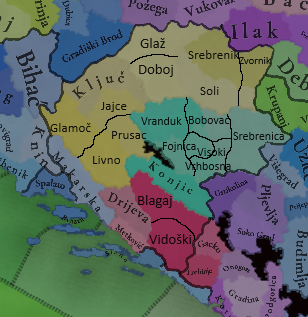
I found little time to make some map changes, like I already wrote, how should provinces and locations in Bosnia look like:


Balkan LocationsALT2.png
Balkan ProvincesALT1.png


I added some changes and propositions for the new provinces, mostly regarding raw goods, but also a few about terrain, religion and culture.

Vrhbosna - Horses (there's a Bosnian Mountain horse breed, and I think, it should be at least one horse producing location because of it. Besides, I'm not sure any other type of raw goods can be tied to this location)

Fojnica - Silver (second most important silver mine after Srebrenica during middle ages, with gold and copper deposits as well)

Bobovac - Lead (Iron is an alternative, but I'll stick with lead, as already said, there's a town with that name there, because of rich lead deposits), terrain should be mountains, not hills

Visoki - Coal (if there's no changing goods in game, like in EU4. If discovering deposits of different mineral will be part of the game, than it should be livestock, later on founding coal)

Vranduk - Furs

Srebrenica - Silver

Blagaj - Olives

Vidoški - Wine

Drijeva - Stone (could be salt)

Gacko - Stone

Trebinje - Wine

Jajce - Livestock

Prusac - Wild game (President of Yugoslavia, Tito, had his hunting villa there, because of rich fauna in this location)

Ključ - Stone

Glamoč - Lumber

Livno - Wheat

Doboj - Wheat

Glaž - Wheat

Soli - Salt (as already said, one of the biggest salt deposist in the region, active even today, town of Tuzla is derived from turkish word for salt-tuz)

Srebrenik - Fiber crops (since it's mostly agrarian part of Bosnia, even today, it fits better than stone), terrain flatlands, not hills.

Zvornik - Legumes

Ustikolina - Lumber (eventually Wild game), terrain Mountains, not Hills. And I think it would be wise to add non passable terrain on the northern half of border with Konjic location.

Bihać - Lumber, terrain should be Hills, not mountains

Gradiški Brod - Wheat (later on Iron deposits could be discovered)


Although Slano isn't part of Bosnia, salt should be raw good produced there, even the name Slano, means salty.


Religious map:

Bosnia and Donji Kraji should have Krstjani majority with catholic minority (exception Srebrenica, orthodox should be minority there, as already present). Usora and Soli should have Krstjani majority, both catholic and orthodox minority, with orthodox being slightly ahead. Una-Sana should be catholic majority, minority of Krstjani (since that part was basically never part of medieval Bosnia, there shouldn't be much of them there).

Hum is most complex, catholics should be majority in Drijeva and Metković, Gacko and Trebinje should be majority orthodox, all having Krstjani minority, Konjic majority Krstjani, catholic minority, Vidoški orthodox majority with catholic as second, and krstjani third minority, while Blagaj is best being split threeways, with no majority at the time.
 
Last edited:
  • 4Like
Reactions:
Dear TintoTalks,

As a Hungarian (and historian) I would like to share you some minor (but significant) erros. The province called "Budapest" is wrong, Budapest as a city was created in 1873 from the unification of Buda, Pest and Óbuda. It should be renamed, or split it at the Danube river to Pest and Buda provinces. Although the two cities were economically attached to eachother. Pest was more like on plains (significant livestock, crafts) and Buda is on hills (significant wine production).

The province called "Bácsa" is wrong, it is "Bács", instead of "Banat" it is "Bánság"

The location names are very bad. Nobody every called these locations in Slovakian or Romanian in Transylvania and todays Slovakia before 1920. Those names are transmitted from the Hungarian names. For example: Făgăraș is from the Hungarian name Fogaras or Trenčín is from Trencsén. So please change all of the Hungarian location names to Hungarian, instead of historical anachronism. -- If you need help with that, I can list you the locations with their actual name, feel free to contact me.

The name "Koloszvár" is wrong, it is "Kolozsvár", flip the "s" and "z" letters.
A historian shouldn't be motivated by nationalistic ideas in order to be taken seriously (by me at least, I'm sure many hungarians are happy with you saying this). Why don't you mention that the etymology of Fagaras/Fogaras is not completly known and there's, generally, 3 theories? 1.Romanian origin. Făgăraș = fag (birch tree) + ar (suffix for professions or crafts) + aș (diminutive). 2. Hungarian origin: fogros/fogoros - a word meaning "a place full of partridge. 3. Pecheneg origin: Fagar šu - meaning "the water of the ash tree".

And I don't think you could ever make the case for no one using the romanian and slovakian names before 1920. That's just plain stupid. Romanians and Slovakians had their own names for places, and yes, many times they adopted the hungarian names and they were adapted to the language. Those people didn't just switch to speaking hungarian every time they wanted to name a city. "Da, fratilor, trebuie sa ma duc pana la GYULAFEHÉRVÁR sa cumpar un pui". - it was just called Bălgrad and, later, a calque from hungarian was created, changing the name to Alba-Iulia.
 
Last edited:
  • 11Like
  • 4
Reactions:
A post literally gave a link to the book Kosovo: a short history
i have to respectfully disagree with that book,
it was published in 1998, same time the kosovo war was brewing (or rather started to boil), and washington was not a neutral party to the conflict, so i'm inclined to believe there was some incentive for the author to present kosovo as not serbian.

i think documents from the time (various charters from serbian kings and an ottoman defter from 1455) are a much better source and there we can find the region consistently had an overwhelming slavic majority
 
  • 3Like
  • 3
  • 2
Reactions:
View attachment 1161720
Here is just a SMALL part of the Serbian churches and monasteries in Kosovo. However, I hope this gives you a good insight into the fact that 95% of the inhabitants were Serbs. I would also like to emphasize that Prizren was the "capital city" of Stefan Uroš IV Dušan Nemanjić, while Skopje was the city where he proclaimed himself Emperor. Please take care of these details.
Weren't Albanians also Orthodox at that time, how do you know if the church was Albanian or Serbian? Even when there was no Albanian Orthodox Church yet, but Albania was under the Greek Orthodox Church and Kosovo was under the Serbian Orthodox Church in relation to the territory of the Principality of Serbia?
 
  • 8
  • 1Haha
  • 1
Reactions:
Yes, I checked your history and thank you for taking the time to make quite tedious suggestions. Let's hope to finally get a better representation of Maramures, with correct namings, saltmining and all. :)

The devs also received a lot of thoughtful and helpful ideas on Transylvania in this thread (therefore I will not make any addition), let's hope for their timely inclusion and, hopefully, fewer reasons for future arguments on the topic.


Taking a second look at it I believe this is a good idea, as Zigeth should be at roughly an equal distance from Baia Mare (to the south) and Khust (to the northwest). However I see no reason for Baia Mare to neighbour Khust to the North, the whole way the area was created is pretty confusing to me.
Yeah, Maramures should definitely get a Salt-tradegood! I remember suggesting this 4 years ago for Eu4, too.

A Maramarossziget location would be ideal for such a tradegood, as Aknaszlatina/Solotyvno and its rich salt mine was basically a stone's throw away.
https://hu.wikipedia.org/wiki/Aknaszlatina (a quick Google-search yields enough information, too).

Does someone know why there are copper-mines in Wallachia, though? I can't find anything about it. EDIT: Never mind, https://en.wikipedia.org/wiki/Baia_de_Aramă
 
Last edited:
  • 2Like
  • 1
Reactions:
Yeah, Maramures should definitely get a Salt-tradegood! I remember suggesting this 4 years ago for Eu4, too.

A Maramarossziget location would be ideal for such a tradegood, as Aknaszlatina/Solotyvno and its rich salt mine was basically a stone's throw away.
https://hu.wikipedia.org/wiki/Aknaszlatina (a quick Google-search yields enough information, too).

Does someone know why there are copper-mines in Wallachia, though? I can't find anything about it.
Rónaszék is also a super important salt mining town next to them: https://hu.wikipedia.org/wiki/Rónaszék
 
  • 2
  • 1
Reactions:
  • 1Like
Reactions:
Certainly! It should be Duchy of Durrazzo lead by the Angevins in Durrës, the rest of the territory they labeled "Albania" is Topia, and the part of the province of Albania that's inside the Despotate of Epirus is Muzaka (which was fully independent and who's representation I've been asking for for months.
I think a setup of 4 Albanian statelets Topia (in the north ),Muzaka (in the south),Gropaj (around Lake Ohrid under Serbian vassalship ) and mataringa on the coast with 1 more being the duchy of durrazo around durres. Although im not an expert on Albanian history so please tell me if i said anything wrong!
 
  • 8
Reactions:
A historian shouldn't be motivated by nationalistic ideas in order to be taken seriously (by me at least, I'm sure many hungarians are happy with you saying this). Why don't you mention that the etymology of Fagaras/Fogaras is not completly known and there's, generally, 3 theories? 1.Romanian origin. Făgăraș = fag (birch tree) + ar (suffix for professions or crafts) + aș (diminutive). 2. Hungarian origin: fogros/fogoros - a word meaning "a place full of partridge. 3. Pecheneg origin: Fagar šu - meaning "the water of the ash tree".

And I don't think you could ever make the case for no one using the romanian and slovakian names before 1920. That's just plain stupid. Romanians and Slovakians had their own names for places, and yes, many times they adopted the hungarian names and they were adapted to the language. Those people didn't just switch to speaking hungarian every time they wanted to name a city. "Da, fratilor, trebuie sa ma duc pana la GYULAFEHÉRVÁR sa cumpar un pui". - it was just called Bălgrad and, later, a calque from hungarian was created, changing the name

Before writing this, I want to note that I love how 28 people disagreed with me before even posting anything lol, great stuff guys.

I won't go on a massive rant because I don't have time, so here's the short version of what I think is wrong with the map:

Moldova shouldn't be integrated in the Golden Horde. We know that prior to the 1346 Moldovan march established by Dragos, who was a romanian noble from transylvania, there were still multiple Moldovan states there, basically various chieftains that would be semi independent, under influence of the horde for the eastern chieftains, influence of hungary for the chieftains next to the mountains in the west and influenced by galicia volhynia for the northern lords.

I have a ton of Romanian sources to back this up, such as Descriptio Moldavae, which was written by Dimitrie Camtemir in the early 1700s, a historian himself and prince of Moldova at the time, BUT I know that it can seem like oh ma ger it's just romanian propaganda, so will give foreign sources, namely the Polish chronicler Jan Dlugosz mentions that Romanians from the Moldovan parts fought alongside the Poles against the Margraviate of Brandenburg in 1342, he also mentions Romanians from Maramures doing the same in his Annals of Jan Dlugosz. He lived in teh early 1400s and is the most accurate and early source we have from the time period of that region.

As for Transylvania, again, if you ask Romanians we got hundreds of sources, if you ask Hungarians they have the same, so I won't quote Romanian sources since they will ofc say that it was majority romanians in Transylvania in 1300s, but will instead mention Byzantine sources and outside sources such as:

Nikephoros Gregoras (1295-1360) - "Roman History" he talks about the Hungarian and Romanian principalities in the 13th and 14th century. Recommend reading the whole thing, beautiful book and contemporary for the period, gives massive insights into why the Hungarian crown brought previously german saxons to settle in Transylvania, as a means of evening out the unbalance of population, since Romanians were the vast majority of people there, were orthodox and refused conversion to catholicism, which was one of the main problems.

Georgius Pachymeres (1242-1310) - "Historia"
Mentions Hungary and neighbours including various lords in the moldovan areas within the 13th and 14th centuries.

Another major thing is that Transylvanian Romanians in 1300s were identical to the Romanians in Moldova and Wallachia. The reality is that Hungary formed Wallachia and Moldova with Romanians from Transylvania LITERALLY in this century, there were no major differences in language or customs between the 3 at the time, this maybe came around as a result of separation between the 2 areas in the NEXT 400 years, but even so, it's more of an accent than any actual different words. By the logic you're using right now, you should have 10 different cultures in England cause of different accents...and that's not how it works.

Also Wallachian as a culture is weird, the people there called themselves Romanians in the 1300s, so you can either call them that, OR call them Vlachs, which is what they were called by Germans, Slavs and by extension Byzantines, which used the words vlach that the slavs used for various political reasons.

If you need more sources, let me know, I got a ton more, just remember to read the whole thing, not look for paragraphs, cause that's now how reading goes, especially when it comes to history.

Much love to all my Balkan brothers and sisters and remember, Rome is eternal.
I agree there is no reason for the existence of a Transylvanian culture but by the same logic there shouldn't be a székely culture either as there were no difference between them and hungarians besides accent but many more different hungarian regions had various accents. One important thing though is that the székely people were freeman, they weren't peasant, they were freeman thus they lived in their own communities, villages and cities, elected their own mayors and leaders in exchange for military service.

Additionally the Unio Trium Nationum should also be included later on in the game.

Transylvania was the first country to adopt freedom of religion so that should be also included via events or smth.

The etnich make-up of Transylvania is kinda good as it is on the map, we obviously do not know the real numbers, however important to note that there were not powerful nobels who were vlach or slovakian, there were only croatiand but as we can see later on in Zrínyi Miklós they considered themselves hungarian as at that time it was really the nobility who thought in terms of nations.

Hungary should have multiple gold and other kinds of mines as this was the period when Hungary produced the most gold in Europe.

The cities in Transylvania were Hungarian or German majority. Additionally the important cities should be independent of nobels as Caroberto strongly relied on them and supported their growth.
 
  • 6
  • 1
  • 1
Reactions: