• We have updated our Community Code of Conduct. Please read through the new rules for the forum that are an integral part of Paradox Interactive’s User Agreement.
Only noticed it just now:
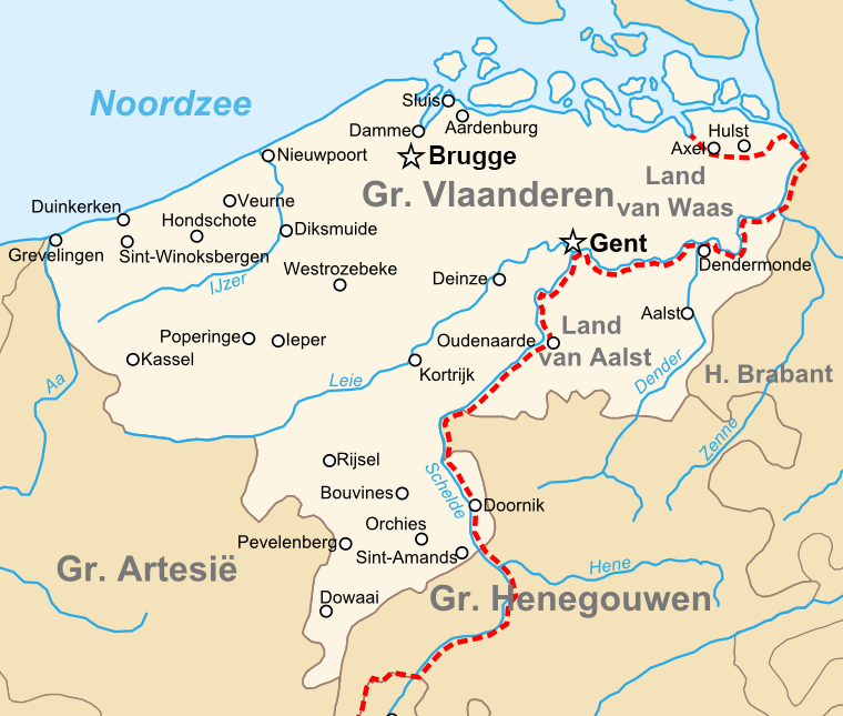
- Sint-Niklaas should not be part of the HRE (although Dendermonde seems to be included in the location, which wás in the HRE).
- Hulst was part of the 'Four labours' (Vier Ambachten), which isn't as big as the entire indicated Hulst Location. Nonetheless, the cities within the 'Four Labors' were definitely the most developed parts so are representative (keep it HRE).
- Tournai was part of the HRE, so if following the same logic for Hulst, could also be included in the HRE

1744206762015.png
1744208146163.png
County_of_Flanders_%28topogaphy%29.png

(note: map on the right: dot of Oudenaarde is on the wrong side of the river, not part of the HRE)
 
Last edited:
  • 12Like
  • 1
Reactions:
I'm quite late in asking this but why was the dynasty name for the duchy of Brabant changed from "van Reginar", like we can see in the original Germany Tinto Maps, to "Rheinhardszoon"?

I can't seem to find any sources, in any languages, using that name for the dynasty. Not even sure who is that "Reinhard" being referenced here. Is it supposed to be an alternative way to write "Reginar"? Because I can't seem to find it written like that.

I think it would be more logical to simply call the dynasty "van Brabant", the same way the dynasty of Hesse is called "von Hesse" by that point even though they also are descendants of the "Reginars". It would also seem more consistent with the naming of most of the other European dynasties. But going back to the use of "Reginar" seems already more logical than using "Reinhardszoon".
 
Last edited:
So we haven't seen the fixed population yet, and this post is probably not going to have any influence whatsoever, but after I did the population map in the original thread, I decided to do some research and make an actual population suggestion map based on estimated population densities for the time period, if only to compare it with what the population numbers in the game end up looking like.

A lot of this is conjecture, I've also used actual estimates as references when possible, for example Brandenburg has been estimated to have had ~200k population and (modern borders of) Saxony ~300k population.
We can assume that population density dropped of a lot the further north and east you went, as those were regions that had been depopulated and settled fairly recently.
On the other hand, the heartlands of Medieval Germany were overpopulated (which contributed a lot to the Ostsiedlung), so this is where I concentrated most of the population.

germanpopsuggestion4.png


Here's the list, with urban population (in cities of 5000 or more) listed as well. I've sorted it by population density
km²people/km²PopulationUrban PopUrbanization
ANorthern RheinlandVery fertile, includes Germany's biggest city, densely populated and urbanized7,29760437,81967,00015%
LRhein-MainVery urbanized, fertile land along the rivers, important for trade6,81860409,05152,00013%
CFertile RuhrFertile, urbanzied, on important trade route3,55555195,51519,00010%
MKraichgau, NeckarFertile and urbanized, used to be even more developed under the Staufer7,82855430,53325,0006%
NUpper Rhine ValleyFertile, not super urbanized6,13840245,52015,0006%
OAlsaceIncludes the Vosges, but fertile along the Rhine8,91138338,63420,0006%
JMagdeburg, Anhalt, Erfurt BasinFertile, urbanized, rich mining21,00036756,00056,0007%
VNorthern AustriaSome fertile land along the Danube, includes Vienna and much of Austria's population33,490361,205,64126,0002%
WFertile Switzerland, VorarlbergFertile Swiss Plateau, includes much of Switzerland's population16,59236597,31619,0003%
DMünsterland, Ostwestfalen, OsnabrückUrbanized, but average fertility12,75734433,75332,0007%
FAngria from Celle to KasselUrbanized, but average fertility, rich from Harz mining16,31634554,74142,0008%
QBavaria, FranconiaIncludes important cities like Nuremberg or Augsburg, average fertility47,469331,566,47794,0006%
BSouthern RheinlandHilly, forested, includes Koblenz and Trier, but rural character in general17,41028487,47111,0002%
SNorthern BohemiaFertile, with rich mining and Prague25,08228702,29223,0003%
PSouthern Swabia, Bavaria, SchwarzwaldLow fertility, agriculture focused on livestock30,25725756,43400%
UMoraviaFertile20,74125518,53521,0004%
KMittelgebirgeHilly woodland, with a few smaller towns, not the most inviting land to settle32,91524789,9726,0001%
TSouthern BohemiaLess fertile, less populated30,74022676,2899,0001%
RBavarian Forest, Upper PalatinateHilly and forested, but important mining16,79320335,86000%
ELower SaxonyLow fertility, low development on the coast, only trade cities are notable32,72018588,95421,0004%
GSchleswig-Holstein, HamburgNot very developed or fertile, but some important trade cities17,65116282,41632,00011%
YSaxonyHad a mining boom and some fertile land, most of the population were recent immigrants30,50016488,00016,0003%
XAlpsMountainous, not a lot of land to settle, sparsely populated71,86513934,24010,0001%
HMecklenburg, PomeraniaOnly the coastal cities are notable (and there are some sizeable ones), the hinterland is mostly undeveloped and not fertile30,1009270,90026,00010%
IBrandenburgRelatively recently settled region, forested, not densely populated36,5007255,5005,0002%

The totals are ~9.3 million for Germany, ~1.9 million for Czechia, ~1.9 million for Austria and ~800k for Switzerland.
 
Last edited:
  • 8Love
  • 5
  • 2Like
Reactions:
So we haven't seen the fixed population yet, and this post is probably not going to have any influence whatsoever, but after I did the population map in the original thread, I decided to do some research and make an actual population suggestion map based on estimated population densities (most sources tend to give the same ranges which I've used) for the time period.

Here's the map (this time it's green to red, densest to least dense!):

View attachment 1280028

And here's the list:

RegionCommentkm²people/km²Population
ANorthern RheinlandVery fertile, includes Germany's biggest city, densely populated and urbanized729728204,315
BSouthern RheinlandHilly, forested, includes Koblenz and Trier, but rural character in general1741013226,326
CFertile RuhrFertile, urbanzied, on important trade route35552588,871
DMünsterland, Ostwestfalen, OsnabrückUrbanized, but average fertility1275715191,362
ELower SaxonyLow fertility, low development on the coast, only trade cities are notable327209294,477
FAngria from Celle to KasselUrbanized, but average fertility, rich from Harz mining1631615244,739
GSchleswig-Holstein, HamburgNot very developed or fertile, but some important trade cities176519158,859
HMecklenburg, Pomerania, NeumarkOnly the coastal cities are notable, the hinterland is mostly undeveloped and not fertile606177424,322
IBrandenburg, Altmark, LusatiaForested, not highly developed yet, nor urbanized404758323,797
JSaxony, Anhalt, Erfurt BasinHighly fertile, very urbanized, rich mining3775220755,048
KMittelgebirgeHilly woodland, with a few smaller towns, not the most inviting land to settle3291511362,070
LRhein-MainVery urbanized, fertile land along the rivers, important for trade681827184,073
MKraichgau, NeckarFertile and urbanized, used to be even more developed under the Staufer782824187,869
NUpper Rhine ValleyFertile, but not very urbanized613820122,760
OAlsaceIncludes the Vosges, but fertile along the Rhine891119169,317
PSouthern Swabia, Bavaria, SchwarzwaldLow fertility, agriculture focused on livestock3025712363,088
QBavaria, FranconiaIncludes important cities like Nuremberg or Augsburg, average fertility4746916759,504
RBavarian Forest, Upper PalatinateHilly and forested, but important mining1679311184,723
SNorthern BohemiaFertile, with rich mining and Prague2508222551,801
TSouthern BohemiaLess fertile, less populated3074016491,847
UMoraviaFertile and relatively urbanized2074119394,086
VNorthern AustriaSome fertile land along the Danube, includes Vienna and much of Austria's population3349020669,801
WFertile Switzerland, VorarlbergFertile Swiss Plateau, includes much of Switzerland's population1659216265,474
XAlpsMountainous, not a lot of land to settle, sparsely populated718656431,188

The totals end up at around 5 million for Germany, 1.4 million for Czechia, 1 million for Austria and 360k for Switzerland which lines up with most estimates that I've seen.


I don't now where did you get the numbers but on this thread, you can see that the numbers are different. The territory of modern Austria should have at least 2 million population in 1337.
 
  • 1
Reactions:
I don't now where did you get the numbers but on this thread, you can see that the numbers are different. The territory of modern Austria should have at least 2 million population in 1337.
I know that McEvedy and Rogers is the main source that Project Caesar uses, but their estimate for pre-Black Death Germany at 10 million is very high, and 25 people per km² for all of Austria in 1337 including the Alps sounds high - the estimated population density of Java that I posted in the Indonesia thread was 20 people per km².
It's basically double of the estimates I've used - which total to around 12 million population in the entire HRE.
That shows how there's very little actual data to base these estimates on, when they can have such a large range - 12 to 25 million for the HRE.

If McEvedy and Rogers are used everywhere to be consistent, then I guess the numbers in my map and table up there can just be doubled!
(I just edited my post to include a map with doubled values, so we can see the whole range)
 
Last edited:
  • 5Like
Reactions:
We have detected that, not only Germany, but a few areas in Europe do have more people than they should, due to some malfunction of our tools that is now solved (the famous issues with the pop editor). These numbers will be corrected soon.
 
  • 13Like
  • 2Love
  • 2
  • 1
Reactions:
We have detected that, not only Germany, but a few areas in Europe do have more people than they should, due to some malfunction of our tools that is now solved (the famous issues with the pop editor). These numbers will be corrected soon.
Is this is why you've delayed posting the pop maps for the recent feedback posts?
 
  • 2Like
Reactions:
As @Pavía has already explained several times, yes.
 
  • 6Like
  • 4Haha
Reactions:
So we haven't seen the fixed population yet, and this post is probably not going to have any influence whatsoever, but after I did the population map in the original thread, I decided to do some research and make an actual population suggestion map based on estimated population densities for the time period.
Edit: Since the population estimates for this time vary so much, and Project Caesar seems to want to stick to a certain estimate to be consistent, I made another map and table where the values are doubled! The actual population in the game should probably be somewhere in this range, and whenever we get the numbers I'll compare them to my map.
Edit2: I also included an estimation of urban population for each region, based on the table in my previous post in this thread.

Here's the map (this time it's green to red, densest to least dense!):


Here's the list:

RegionCommentAreaLower EndUpper EndUrbanization
km²people/km²Populationpeople/km²PopulationUrban PopLowerUpper
ANorthern RheinlandVery fertile, includes Germany's biggest city, densely populated and urbanized7,29728204,31556408,631100,00049%24%
BSouthern RheinlandHilly, forested, includes Koblenz and Trier, but rural character in general17,41013226,32626452,65128,00012%6%
CFertile RuhrFertile, urbanzied, on important trade route3,5552588,87150177,74136,00041%20%
DMünsterland, Ostwestfalen, OsnabrückUrbanized, but average fertility12,75715191,36230382,72450,00026%13%
ELower SaxonyLow fertility, low development on the coast, only trade cities are notable32,7209294,47718588,95435,00012%6%
FAngria from Celle to KasselUrbanized, but average fertility, rich from Harz mining16,31615244,73930489,47855,00022%11%
GSchleswig-Holstein, HamburgNot very developed or fertile, but some important trade cities17,6519158,85918317,71845,00028%14%
HMecklenburg, Pomerania, NeumarkOnly the coastal cities are notable (and there are some sizeable ones), the hinterland is mostly undeveloped and not fertile60,6177424,32214848,64343,00010%5%
IBrandenburg, Altmark, LusatiaRelatively recently settled region, forested, not highly developed, nor urbanized40,4758323,79716647,59437,00011%6%
JSaxony, Anhalt, Erfurt BasinHighly fertile, urbanized, rich mining37,75220755,048401,510,096134,00018%9%
KMittelgebirgeHilly woodland, with a few smaller towns, not the most inviting land to settle32,91511362,07022724,14137,00010%5%
LRhein-MainUrbanized, fertile land along the rivers, important for trade6,81827184,07354368,14668,00037%18%
MKraichgau, NeckarFertile and urbanized, used to be even more developed under the Staufer7,82824187,86948375,73840,00021%11%
NUpper Rhine ValleyFertile, but not very urbanized6,13820122,76040245,52016,00013%7%
OAlsaceIncludes the Vosges, but fertile along the Rhine8,91119169,31738338,634no data
PSouthern Swabia, Bavaria, SchwarzwaldLow fertility, agriculture focused on livestock30,25712363,08824726,17617,0005%2%
QBavaria, FranconiaIncludes important cities like Nuremberg or Augsburg, average fertility47,46916759,504321,519,008119,00016%8%
RBavarian Forest, Upper PalatinateHilly and forested, but important mining16,79311184,72322369,4469,0005%2%
SNorthern BohemiaFertile, with rich mining and Prague25,08222551,801441,103,60239,0007%4%
TSouthern BohemiaLess fertile, less urbanized30,74016491,84732983,6939,0002%1%
UMoraviaFertile and relatively urbanized20,74119394,08638788,17331,0008%4%
VNorthern AustriaSome fertile land along the Danube, includes Vienna and much of Austria's population33,49020669,801401,339,60241,0006%3%
WFertile Switzerland, VorarlbergFertile Swiss Plateau, includes much of Switzerland's population16,59216265,47432530,94857,00021%11%
XAlpsMountainous, not a lot of land to settle, sparsely populated71,8656431,18812862,37519,0004%2%

The totals are around 5-10 million for Germany, 1.4-2.8 million for Czechia, 1-2 million for Austria and 360k-720k for Switzerland.
For Switzerland, this seems quite low as well. It is estimated that in 1300 there were between 700k and 850k living in modern day Switzerland's borders, with an ongoing growth til the middle of that century. According to the Historical Dictionary of Switzerland.
 
  • 1Like
Reactions:
For Switzerland, this seems quite low as well. It is estimated that in 1300 there were between 700k and 850k living in modern day Switzerland's borders, with an ongoing growth til the middle of that century. According to the Historical Dictionary of Switzerland.
That's interesting, the estimate does mostly align with the upper end of my numbers, but what I'm particularly interested in are the urbanization percentages given. We do have a dataset of cities with at least 5000 population in 1300, so that allows us to calculate the total population estimates they used.

For Switzerland, they say that the population in cities >= 5000, which would be Basel (7000), Lausanne (6000) and Zürich (6000), is less than 3%, which suggests the total population was at least 655k.
For Germany, it gives a surprisingly exact number of 7.9%, so the 519 000 people that lived in cities of 5000 or more would translate to a total German population of 6.57 million which is on the low end.
In France, the city population was 853 000 which, at 8%, translates to a total population of 10.66 million, which is also lower than most estimates I've seen.
In Italy, the city population of 1 466 000 and a percentage of 20.8% translates to a total population of 7 million which is also well below the usual estimates.

Obviously rounding errors and smaller inaccuracies make the final numbers quite imprecise here (on top of the general "nobody has any actual data"), which is why I'm surprised that they give such precise numbers for urbanization in the first place. I'd be interested in where these come from. Switzerland also seems to be the only country with its estimate at the upper end.

In any case, I did update my post above since I settled on a single estimate now that should be pretty good I think, it's actually very similar by country to the original population (except for Germany which was bugged), just distributed more according to what you'd expect, not placing most of Austria's population inside the Alps.
 
Last edited:
  • 2Love
  • 1Like
Reactions:
Maybe I'm wrong but shouldn't Bar be both a french vassal and HRE member in 1337? It doesn't seem like the county's status changed except for being elevated to a duchy and as such should be an more like (as far as the HRE map is conserned) Valentinois is, an HRE member which holds land outside the HRE.
 
Maybe I'm wrong but shouldn't Bar be both a french vassal and HRE member in 1337? It doesn't seem like the county's status changed except for being elevated to a duchy and as such should be an more like (as far as the HRE map is conserned) Valentinois is, an HRE member which holds land outside the HRE.
So Bar is split between two parts: Barrios mouvant in the south around the town of Bar, which in 1301 became subject to France, and Barrois immouvant in the north, which remained a fief of the HRE, and was not a subject of France. So while it's a French vassal and an HRE member, it's never both at the same time!
 
  • 2Like
Reactions:
So Bar is split between two parts: Barrios mouvant in the south around the town of Bar, which in 1301 became subject to France, and Barrois immouvant in the north, which remained a fief of the HRE, and was not a subject of France. So while it's a French vassal and an HRE member, it's never both at the same time!
Right but that's not really represented here, instead Bar is a french vassal occupying HRE land. Given that the only way to represent the historical reality would be with two somehow interlinked tags (PU between the two Bars?) and I can't see that working, Bar as an HRE member which is also a french vassal seems like the best arrangement.
 
  • 2
Reactions:
Is there any particular reason why you decided to go with the "Danube Bavarian" culture? Wouldn't it be easier to just divide Bavarian and Austrian?
 
First of all awesome that you added Oppenheim as a location.
However I am unsure why it's owned by the Palatinate at the start date. Around this time period Oppenheim was property of the imperial crown which was mortgaged (verpfändet) multiple times and to multiple people. At the time of 1337 it was mortgaged to the Archbishop of Mainz. In 1353 the Emperor actually paid the outstanding money and regained "ownership" of the town (would be a cool event to spawn Oppenheim as an independent imperial city by paying some ducats). It was only pledged/mortgaged/verpfändet to the Palatinate a few years later on and then eventually became a proper part of the Palatinate.

So in my opinion it makes no sense to have the location be owned by the Palatinate. It should rather be owned by Mainz or be an independent imperial city.

Oppenheim's German Wikipedia page cites Versuch einer vollständigen Geographisch-Historischen Beschreibung der Kurfürstl. Pfalz am Rheine from Johann Goswin Widder (1787) as a source, which is available on Google Books where the entire situation is described. (Wikipedia Source 11 links you the right part of the book)
 
  • 3Like
  • 3
  • 1
Reactions: