• We have updated our Community Code of Conduct. Please read through the new rules for the forum that are an integral part of Paradox Interactive’s User Agreement.
Pskov has a weird shape
View attachment 1237734View attachment 1237736
Although hese two maps are respectively from 1422 and 1444 we can see that the location of Gdov doesn't extend that far east and instead it should follow the more natural border of the Plyussa river since it makes more sense, while the location of Pietālava(today's Pytalovo) in Livonia should be reshaped to reflect the area of contested terrirtory during this period, in the Poland feedback I said that it should also be moved in the province of South Pskov but after doing some more research I take that back

I agree. Pskov borders are better what they were before, but it still could be better.

View attachment 1237738View attachment 1237739
Unfortunately I wansn't able to find any anything regarding the southern and eastern borders of the republic but in these maps it's clearly different than the one in the game but I have no idea if it's because it changed after 1337 or it's just made up due to the scarcity if information, also can you rename the two provinces to Pskov and Ostrov please?
Contested border and current border of Pietlava is the same. That is one of the most correctly drawn locations in that region. There are many maps that show that this border was where it is in the game currently. When I made my feedback for this region, I compared many maps and the only one that differed is the map you have as you first picture.

Source of the pic below: In depth and well researched book about Dorbat bishopric. Name: "Tartu piiskopkond, 1224–1558. Kõige võimsam territoorium". Map shows the borders of Livonia in 1340.

43138f1e-e666-4c9a-a562-a44a0efae858.jpg
 

Attachments

  • d8fb5317-34e6-46fa-a335-b276ce1713c4.jpg
    d8fb5317-34e6-46fa-a335-b276ce1713c4.jpg
    159,8 KB · Views: 0
Last edited:
  • 3Like
  • 1
Reactions:
Pskov has a weird shape
View attachment 1237734View attachment 1237736
Although hese two maps are respectively from 1422 and 1444 we can see that the location of Gdov doesn't extend that far east and instead it should follow the more natural border of the Plyussa river since it makes more sense, while the location of Pietālava(today's Pytalovo) in Livonia should be reshaped to reflect the area of contested terrirtory during this period, in the Poland feedback I said that it should also be moved in the province of South Pskov but after doing some more research I take that back
View attachment 1237738View attachment 1237739
Unfortunately I wansn't able to find any anything regarding the southern and eastern borders of the republic but in these maps it's clearly different than the one in the game but I have no idea if it's because it changed after 1337 or it's just made up due to the scarcity if information, also can you rename the two provinces to Pskov and Ostrov please?
Not sure about this. Searching in Russian, I found several maps with borders that match the in-game ones.

Borders in 1462. From the Russian Wikipedia page for the Pskov Republic.
1735659127852.png


This map showed up when googling Псковская республика. Couldn't access the page though.
1735659283117.png


Novgorod's Shelonskaya Pyatina, which bordered Pskov. From Wikipedia too.
1735659208116.png
 
  • 4Like
  • 1
Reactions:
Not sure about this. Searching in Russian, I found several maps with borders that match the in-game ones.

Borders in 1462. From the Russian Wikipedia page for the Pskov Republic.
View attachment 1237898

This map showed up when googling Псковская республика. Couldn't access the page though.
View attachment 1237902

Novgorod's Shelonskaya Pyatina, which bordered Pskov. From Wikipedia too.
View attachment 1237900
Interesting, although in the case of the first one Pskov has control up to the coast and as you pointed out the map is from 1462 so maybe that wasn't the case in 1337? The Pyatinas were made in the late 15th century too so that's also much later on, that said my maps are from a century later...can you find the date of your second map?
 
Contested border and current border of Pietlava is the same. That is one of the most correctly drawn locations in that region. There are many maps that show that this border was where it is in the game currently. When I made my feedback for this region, I compared many maps and the only one that differed is the map you have as you first picture.
Ah I noticed it now, for some reason my dumbass thought it looked different! Thanks!
 
  • 1Like
Reactions:
Interesting, although in the case of the first one Pskov has control up to the coast and as you pointed out the map is from 1462 so maybe that wasn't the case in 1337? The Pyatinas were made in the late 15th century too so that's also much later on, that said my maps are from a century later...can you find the date of your second map?
Unfortunately I couldn't find the date. Using the Wayback Machine I was able to see the page, but it didn't give a date for the map (https://web.archive.org/web/20240228083105/https://bigenc.ru/c/pskovskaia-respublika-379440). I also found another page which uses the map but it has no date either (https://dzen.ru/a/ZUYypOebbVqoh0PN). It could simply be that some maps don't show the border in as much detail as the others. It's certainly the case for a lot of Nordic history. If it is a border change its probably some really obscure one that might not even have anything about it on the internet.
 
  • 1Like
Reactions:
Actually Sergiyev Posad is inside the borders of the location of Pushkino, just in the upper triangle next to the northern tip of Rogozh and very close to crossing the border to Bogorodskoye.

I removed it because of the size of the locations, the historical borders between the states and because in 1337 Pushkino was more relevant that Sergiyev Posad. I am going to be honest, I was not specially thrilled with removing Sergiyev Posad as I am aware of its importance, but this is one of those situation where two important settlements share a location and you have to sacrifice one in order to not ruin the whole setup due to a cascade of consequences for adding it.

That being said, Sergiyev Posad, while not having a location named after it, is in the game in other ways. More for that likely when flavor for the region is shown. :D
Thanks for responding! That makes sense.

I was under the impression that Pushkino was also just a small village if it exsited at the time, and that it wasn't mentioned in sources until the late 15th century, but I assume you have better sources.
 
I don't now if it fits better here or for the Steppes feedback, but several notes on the Severian lands:

COUNTRIES

  • Novgorod-Seversky should be Novhorod-Siversky to correspond with the respective location and Ukrainian dialect in the game. Also even though there are no exact data about its ruler, but it should be probably also a random Rurikovych Dynasty guy
  • Kyiv, Halych, Volhynia, Chernihiv, Novhorod-Siversky (maybe some others too, I don't know about all those Russian principalities that much) should pay tribute to the Golden Horde directly, not via Ivan Kalita. I don't know if it is implemented in the Tatar Yoke IO

LOCATIONS
  • Znobov should be Znob - one of the oldest settlements, it was visited in 1457 by Kazimierz IV Andrzej Jagiellończyk
  • Please, rename Ripky to Lubech or better make it a separate location. Lubech is an ancient town known since the X century, which hosted Council of Lubech (in 1097). Ripky is just a random village founded centuries later:
  • You mentioned renaming Kharkiv into Donetsk, it just looks funny :D , but I understand that it's due to the Donets river? Is't it in the Steppes?
  • I have noticed that Belarusian locations have different transliteration rules:

PPROVINCES
The provinces in the region are not perfect:
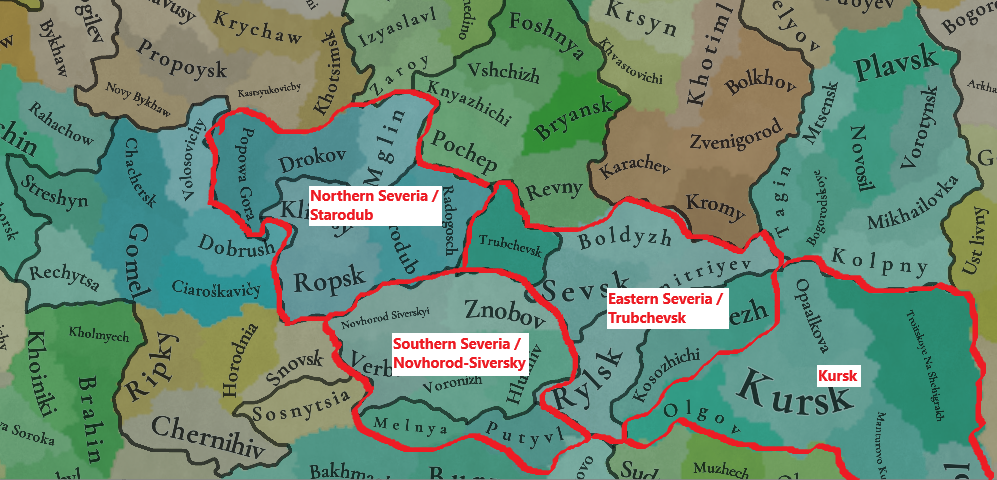
  • Trubchevsk has a really weird form, while the nearby Kursk is much bigger that the others
  • Putyvl belonging to the Trubchevsk province is not natural at all
  • Novgorod-Seversky is a Russian transliteration, while everything else is Ukrainian (including the respective location)

I suggest:
  • Correct the name of Novgorod-Seversky to Novhorod-Siversky or better to Southern Severia to avoid transliteration bias, together with Starodub to Northern Severia, Trubchevsk to Eastern Severia
  • Transfer Putyvl to Southern Severia, where it naturally and historically belongs to (e.g., the prince Igor Svyatoslavovych in 'The Tale of Igor's Campaign' was the prince of Novhorod-Siversky. His wife was waiting for the prince in Putyvl)
  • Transfer Kosozhichi and Fatezh from Kursk to Eastern Severia/Trubchevsk
  • This way all the provinces will have 6-7 locations and the borders look nice and natural:


AREAS

Areas need an important rework too:
  • Firstly, Gomel province should belong to Severia. The Dnipro river makes a perfect natural border between the Black Ruthenia and Severia here. Gomel had been a core holding of Chernihiv for senturies and was considered as Severia too. You portraied it perfectly in the cultures map
  • Secondly, Sloboda Ukraine goes way too far to the north and include the lands that has never been Sloboda-Ukraine. This area should be renamed to the Kursk Area.
  • Concerning the Sloboda-Ukraine I made a suggestion in the Steppes TM, this is where it belongs:
Lastly, I liked that Kyiv area was called Ukraine, I don't know why you changed it. East/West Dnipro are probably the worst possible options just because there are more historical or flavourful alternatives:
  • The lands around the Dnipro were never referred to as West/East in chronicles or the people.
  • Those were either the Right/Left Bank or just Kyiv Land/Pereyaslav Land (Київська Земля, Переяславська Земля).
  • It was definitely referred to as Ukraine already by the 1500s because the name Ucrania firsty appeared in the European (French) travel map, in the mid-XVI century. That means the locals started to call this land Ukraine much earlier, quite early within the game time frame.
  • The word Ukraine itself firstly appeared in cronicles of 1189, then 1214 and later on, so there is no problem with calling the area Ukraine, and on the other side Pereyaslav (see the map above)
  • That is why I also think that White Ruthenia area can be also called Belarus, as long as this is literally what it means

VEGETATION
Much better now, just a couple of corrections needed:
View attachment 1228212
  • no grasslands so far to the north in Polesia
  • no sparse in Hlukhiv, I come from this area exactly and that's how it looks like here :):
View attachment 1228214

DEVELOPMENT & POPULATION
  • It was probably adjusted just by the climate/vegetation, probably development and population should be higher around the duchies' capital locations (Chernihiv, Novhorod-Siversky, they have the lowes development in their duchies).
  • Also Putyvl and Ovruch vere quite important centres of the Kyivan land according to 'Ukraine under the Tatars and Lithuania' (Rusyna O.V.,1998), (pages 32, 33 and 35) and should have higher development and population compared to others:
View attachment 1239843
View attachment 1239867


View attachment 1239842


So I think that these things should be taken into account, Putyvl and Ovruch should have higher development, population and attention within the Kyiv land.
And Chernihiv, Novhorod-Siversky as the capital towns of their duchies:
View attachment 1239936

CULTURES & LANGUAGES
Very good change with the Ruthenian/Russian languages!
But Ukrainian and Belarusian dialects probably should not go too far to the east to Ryazan.
This can be either changed by expanding the Muscovite culture to that lands or by creating a separate culture under Russian language and dialect in that area (it can be called Ryazanian or Verkhovian due to the Verkhovian Duchies, see Upper Oka Principalities article):
View attachment 1228219View attachment 1228218

This way the dialect/language map would feel more natural:
View attachment 1228220

RAW GOODS
Look great! much more diverse now :)


Thanks @Pavia and the whole team for your dedication and work!
As long as I had some time for a deeper research, I made an update to my feedback on Severia.
Also as long as this region always appears divided on the edges of the three TMs (Ruthenian, The Steppes, Russian), I will post this update in all three threads, sorry.
I will post here only the updated parts from the post.

____________________

DEVELOPMENT & POPULATION
  • It was probably adjusted just by the climate/vegetation, but development and population should be higher around the duchies' capital locations (Chernihiv, Novhorod-Siversky, they have the lowest development in their duchies for some reason).
  • Also Putyvl and Ovruch vere quite important centres of the Kyivan land in the first half of the XIV century according to 'Ukraine under the Tatars and Lithuania' (Rusyna O.V.,1998), (pages 32, 33 and 35) and should have higher development and population compared to others:
Putyvl.png

Putyvl1.png

Though, concerning the fate of the princes of Putyvl [after the Mongol invasion], there are at least some sources on them in the Novohorod-Siversky church notes (or 'synodyk', that was called 'a bright ray in the dark times of Kyiv after the Batu invasion'). Synodyk mentiones [Kyivan princes] Ivan (Ioann) of Putyvl, his son Ivan-Volodymyr Ivanovych of Kyiv, Andriy of Ovruch (could be the brother of the latter) and his son Vasyl (that was killed in Putyvl) [those are the princes of the first quarter of the XIV century, around 1290 – 1325, as mentioned in the second screenshot].
Probably after having secured the Kyiv throne, Putyvl princes established a strong connection between Kyiv and their 'fatherland', its traces are then observed for the next 200 years. In the acts of the second half of the XV century it was mentioned that Putyvl taxes went to Kyiv and that all Putyvl governors were Kyivan nobles only.
Then (after the Lithuanian-Moscow peace of 1503) Kyivan elites send petitions to the Polish/Lithuanian king Sigismund I the Old that they were very disappointed with the loss of Putyvl that was 'Kyivan holding with 14 volosti around it...'

Ovruch.png

The fact that Ovruch had its own prince meant that it had become quite an important (maybe the second after Kyiv) administrative centre of the Kyiv land in the XIV century. Probably due to the fact that Kyiv lost control of the South, where the Tatars had direct rule.

So I think that these things should be taken into account, Putyvl and Ovruch should have higher development, population and attention within the Kyiv land.
And Chernihiv, Novhorod-Siversky as the capital towns of their duchies:
Development.png


I also think that Chernihiv and Bryansk should be towns due to their historic and regional importance (instead of Kursk that was completely burnt by the Horde twice during 50 years before the game start date).
If Norway has 6 towns, including Hamar with ~6 thousand population, then I think Chernihiv and Bryansk can be towns too.

COUNTRIES
  • Novgorod-Seversky should be Novhorod-Siversky to correspond with the respective location and Ukrainian dialect in the game. Also even though there are no exact data about its ruler, but it should be probably also a random Rurikovych Dynasty guy (probably from the Chernihiv branch), not just a random guy
NS.png
Countries.png
  • Kyiv, Halych, Volhynia, Chernihiv, Novhorod-Siversky (at least these, maybe some other too) should pay tribute to the Golden Horde directly, not via Ivan Kalita. I don't know if it is implemented in the Tatar Yoke IO. but Chernihiv, Kyiv, Kursk other Severian duchies had their ows baskaks from the Horde who collected the tribute to the Horde.

LOCATIONS
  • Please, add Lubech location, or at least rename Ripky to Lubech. Lubech is an ancient town known since the X century, that hosted Council of Lubech (in 1097). Ripky is just a random village first mentioned in 1607:
Lubech.png
Ripky.png
  • I have noticed that Belarusian locations have different transliteration rules, probably should be unified:
Locations_BelTranslit.png

PPROVINCES
The provinces in the region are not perfect:
  • Trubchevsk has a really weird form, while the nearby Kursk is much bigger that the others
  • Putyvl belonging to the Trubchevsk province looks strange
  • Novgorod-Seversky is a Russian transliteration, while everything else is Ukrainian (including the respective location)
Provinces_Bad.png

I suggest:
  • Correct the name of Novgorod-Seversky to Novhorod-Siversky or better to Southern Severia to avoid transliteration bias, together with Starodub to Northern Severia, Trubchevsk to Eastern Severia
  • Transfer Putyvl to Southern Severia, where it naturally belongs to (e.g., the prince Igor Svyatoslavovych in 'The Tale of Igor's Campaign' was the prince of Novhorod-Siversky. His wife was waiting for the prince in Putyvl)
  • Transfer Kosozhichi and Fatezh from Kursk to Eastern Severia/Trubchevsk
  • This way all the provinces will have 6-7 locations and the borders look nice and natural:
Locations_Provinces.png
Provinces_Proposed.png


AREAS
Areas need an important rework too:
Areas_Better.png
  • Firstly, Gomel province should belong to Severia. The Dnipro river makes a perfect natural border between the Black Ruthenia and Severia here. Gomel had been a core holding of Chernihiv for centuries and was considered as Severia. You portraied it perfectly in the cultures map btw.
Areas_SeveriaPerfect.png
  • Secondly, Sloboda Ukraine goes way too far to the north and include the lands that has never been Sloboda-Ukraine. This area should be renamed to the Kursk Area. And Sloboda(-Ukraine) must be created on its historical lands to the south of this Kursk Area
  • Concerning the Sloboda-Ukraine I made a suggestion in the Steppes TM, this is where it belongs (trust me, I come from Sloboda-Ukraine :) ):
Areas.png
Lastly, I liked that Kyiv area was called Ukraine, I don't know why you changed it. East/West Dnipro are probably the worst possible options just because there are more historical or flavourful alternatives:
  • The lands around the Dnipro were never referred to as West/East in chronicles or the people.
  • Those were either the Right/Left Bank or just Kyiv Land/Pereyaslav Land (Київська Земля, Переяславська Земля).
  • It was definitely referred to as Ukraine already by the 1500s because the name Ucrania firsty appeared in the European (French) travel map, in the mid-XVI century. That means the locals started to call this land Ukraine much earlier, quite early within the game time frame.
  • The word Ukraine itself firstly appeared in cronicles of 1189, then 1214 and later on, so there is no problem with calling the area Ukraine, and on the other side Pereyaslav (see the map above)
Ukraine.png
  • That is why I also think that White Ruthenia area can be also called Belarus, as long as this is literally what it means
 
Last edited:
  • 6Like
  • 4Love
  • 1
  • 1
Reactions:
After looking through available info on Russian wikipedia and some additional sources, I got additional comments on the area around Rylsk and Kursk.
1. I was probably wrong about the extent of Severians - the area around Sevsk and Kursk should be Severian culture, rather than Okan. It was inhabited by the Severian tribe before their assimilation into Kyivan Rus and it was part of Chernihiv.

2. Olgov, Kosozhichi, Dmitriyev, and probably Fatezh locations should be part of Rylsk. Dmitriyev's clergy is known to have been dependent on the monastery of Rylsk, and the Knyaz of Rylsk was at one point allied with the Knyaz of "Lipovichsk/Lipovichesk", which is mentioned twice in the late 1200s before disappearing, and is believed to have been near Dmitriyev.
Kursk was plundered as punishment for a rebellion by the Knyaz of Rylsk against the hordes in the 1280s; it changed hands every now and then, but overall Kursk and the two locations north and east of it are fine to stay as part of Golden Horde.

3. In the early 1300s, the area between Rylsk and Kursk (Posemye) was part of Kyiv, ruled from Putyvl. I'm not sure how to represent this; perhaps as Rylsk being a vassal of Kyiv and owning Putyvl? Rylsk also seems to have been under some influence from Lithuania as early as 1300, but full control doesn't seem to have been established until about 1360, when Lithuania took control over most of Eastern Ukraine and adjacent areas from the Golden Horde.

4. Radogoshch is speculated to have been part of Novhorod-Siverskyi; however, I can't find any solid evidence.

I've updated my map from an earlier post accordingly:
View attachment 1236414
And the suggested border map:
View attachment 1236185
1736125456028.png

I would make these changes on top of this.
1736125173104.png

 
  • 3Like
Reactions:
  • 2Like
Reactions:
That might make sense as minorities, but almost certainly not as a majority (which is what my map was an estimate of). For example, Kharkiv had Slavic settlements pre-1240, but they seem to vanish after the Mongol invasion.
Apparently the settlement was not abandoned.
After the devastation, Donets gradually revived [ 64 ] . According to V. I. Kadeev , this is indicated by the fragments of red clay glazed dishes found by B. A. Shramko , now kept in the archaeological museum of Kharkov University , which may date back to the 13th-14th centuries [ 65 ] . Nevertheless, the city clearly decreased in size, and the deserted part of the settlement was turned into a cemetery [ 66 ] . The final desolation of Donets occurred in the 15th century [ 67 ] .

At the same time, a few kilometers from the old city, on today's University Hill , a new settlement emerged. Its remains were discovered by A. S. Fedorovsky in 1928 [ 68 ] [ 69 ] [ 70 ] . Excavations on Kvitki-Osnovyanenko and Rymarskaya Streets in Kharkov allowed dating this settlement to the 13th-14th centuries [ 71 ] . In 1986, archaeologist Yu. V. Buinov encountered ancient Russian ceramics while digging a test pit on Constitution Square [ 72 ] . Nearby, on Pavlovskaya Square , archaeologists discovered traces of a burial ground from the time of the Golden Horde [ 73 ] . In the 17th century, construction of the Kharkov Fortress began on this very site, on the Kharkov settlement [ 74 ] .
 
  • 2
Reactions:
Not sure if it's better to write this in the Steppe Tinto Maps or here, but Krasnoslobodsk was only called like that since 1780 when it became a town, before that it was called Krasnaya Sloboda (Красная Слобода).
 
  • 1Like
Reactions:
  • 2Like
Reactions:
Apparently the settlement was not abandoned.
That might make sense as minorities, but almost certainly not as a majority (which is what my map was an estimate of). For example, Kharkiv had Slavic settlements pre-1240, but they seem to vanish after the Mongol invasion.

The devs actually renamed Kharkiv to Donetsk (but showed it here instead of the Steppe TM), if you open the spoiler with location changes:
Kharkiv to Donetsk
So probably Slavic population is expected there.
 
  • 1
Reactions:
The thread on the Old/Modern Greek language made me think if the Church Slavonic should be the court language of Novgorod, Tver, Muscovy, ... and all those who use Russian?
It was definitely an official writing language for a very long time in Muscovy, but can it be considered as court language like Latin in Catholic bishopries?
I do not know if it has already been discussed.
What do you think?
 
  • 4
  • 1
Reactions: